During the spring, high water from melting snow makes it possible to explore the whole length of the canyon from the river. The rapids are Class II, so one does not need prior white water experience to navigate them. At the end of the summer, when the water is lower, the full length of the canyon is not navigable, but there are various walks with opportunities for swimming in various pools and streams.
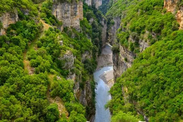
The edges of the canyon have an unusual ecosystem that preserves the greenery on both sides of the canyon year-round. Mediterranean bushes like heath and briar flourish along with rich flora and fauna. On the slopes of the canyon, erosion has created pockmarked cavern walls with small caves. Some of the rock formations in the canyon have fanciful names such as the Cathedral, the Eye, and the Demon’s Door. The canyons are 26 km (16 miles) long, at an altitude of 450 m. They are thought to have been formed 2-3 million years ago by water erosion.
It is generally thought that many years ago the river flowed underground, but over time the rock above the river disappeared, creating the current form of the canyon. In the gulf of this canyon that passes Osum River in both its sides, water flows come from different villages which pass in a rock chain. The local inhabitants tell many interesting legends, such as those of Saint Abaz Ali. The canyon includes six narrow sections ranging from 1.5 m wide in the riverbed up to 35 m wide further up the sides of the canyon.
Gradeci Canyon, the most beautiful and spectacular canyon of the valley of Osumi, stands close to the cave. It is 4 km long, 40 m high, and in different spots, only 1.5 m wide. Its slopes descend rapidly into the river. To reach the other canyons of Osumi, you must journey southward. These other canyons are located 3 km south from the town of Çorovoda. They are magnificent natural objects with a total length of 15 km. In this area, you can practice water sports like canoeing, rafting and kayaking. There are also several spots that serve as small beaches, such...
Read more