Minyon Falls Lookout: A Thrilling View Worth the Treacherous Drive
Minyon Falls, nestled within the magnificent Nightcap National Park in the Northern Rivers region of NSW, is undoubtedly one of the most spectacular natural attractions in the area.
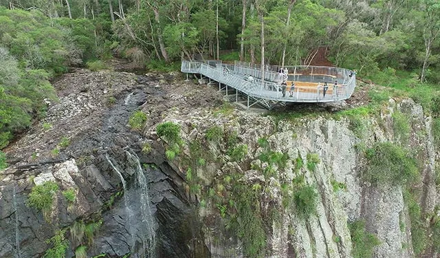
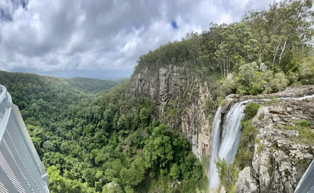
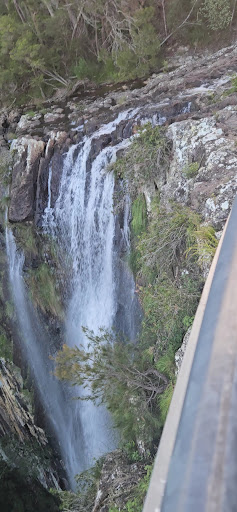
The view from the lookout, where the 100m cascade plunges over the rhyolite cliffs into a deep, palm-shaded gorge below, is breathtaking.
On a clear day, you can often see all the way out to the coastline.
The lookout platform is easily accessible via a short, gentle walk from the main car park, making it perfect for all fitness levels. However, reaching this slice of paradise is an adventure in itself, and requires serious preparation—and a careful choice of vehicle.
A Warning About Road Conditions
Visitors must be fully aware that the journey to Minyon Falls is challenging and should not be undertaken lightly, especially after heavy rain.
Access to Minyon Falls is only via Minyon Falls Road.
The roads leading into the National Park are often single-lane in stretches, narrow, and winding, requiring extreme caution and low speeds. Visibility around corners can be poor.
The final section of the approach, particularly along Minyon Falls Road, is unsealed (dirt/gravel) and notoriously rough. Deep potholes, large rocks, and deep run-off ditches are common, posing a significant risk to the underside and tires of low-clearance vehicles.
While some sedans can make it if driven slowly and with great care, a 4WD or high-clearance vehicle is strongly recommended, especially if wet weather is forecast or has recently occurred. The dirt tracks become extremely muddy and slippery when wet.
The drive itself demands full concentration, but the reward at the end makes the bumpy, slow journey worthwhile.
Exploring the Tracks!!
From Easy Viewpoints to Hard Climbs
Once you arrive, Minyon Falls offers several walking tracks to suit different energy levels.
Minyon Falls Lookout (Easy)
• Distance: Very short, 50\text{m} to 100\text{m} return walk from the car park.
• Grade: Easy.
• Highlights: Panoramic views over the gorge, waterfall, and the distant coast. Picnic tables are available here.
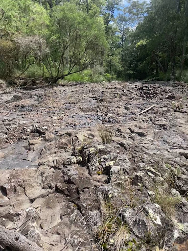
Minyon Grass to Base of Minyon Falls (Hard)
• Distance: Approximately 4\text{km} return.
• Time: Around 2 hours.
• Grade: Hard/Strenuous.
• Highlights: This is the most direct route to the base of the falls and the beautiful natural swimming hole. However, the final 100\text{m} involves a challenging rock scramble over large, often wet and slippery boulders to reach the pool at the base of the 100\text{m} drop.
Minyon Loop Walking Track (Moderate/Hard)
• Distance: 7.5\text{km} to 13\text{km} circuit (depending on start point).
• Time: 3.5 to 5 hours.
• Grade: Moderate to Hard.
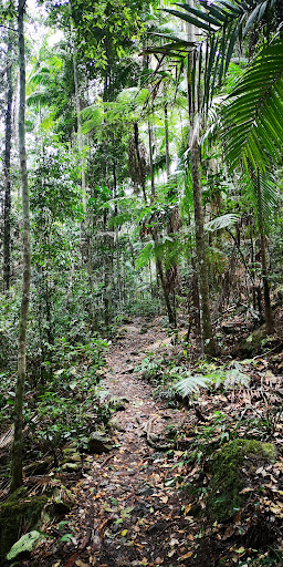
• Highlights: This full circuit allows you to experience the diverse landscape, passing through ancient subtropical rainforest, alongside fern-lined creeks, and showcasing towering old-growth brushbox trees before descending to the base of the falls.
Be prepared for steep sections on the return climb.
Essential Preparation for Visitors
Due to the remote location and potential challenges of the drive and the trails, you must come prepared:
Sturdy hiking shoes with excellent grip are essential, particularly for the rock scrambling near the base of the falls and the steep, potentially slippery loop track.
• Water: Carry plenty of drinking water (at least per person for the longer walks).
• Leech Protection: After rain, leeches are common in the rainforest sections. Wear long socks and consider insect repellent.
• Weather: Check the forecast and wear appropriate clothing (layers, rain gear). If the falls are the main attraction, visit after recent rainfall to ensure a strong flow; they can be reduced to a trickle in dry spells.
• Safety: Always advise a friend or family member of your travel plans and expected return time, as phone reception can be...
Read more