HTML SitemapExplore

Grossglockner — Attraction in Heiligenblut am Großglockner

Name
Grossglockner
Description
Nearby attractions
Nearby restaurants
Nearby local services
Nearby hotels
Related posts
Keywords
Grossglockner tourism.Grossglockner hotels.Grossglockner bed and breakfast. flights to Grossglockner.Grossglockner attractions.Grossglockner restaurants.Grossglockner local services.Grossglockner travel.Grossglockner travel guide.Grossglockner travel blog.Grossglockner pictures.Grossglockner photos.Grossglockner travel tips.Grossglockner maps.Grossglockner things to do.
Grossglockner things to do, attractions, restaurants, events info and trip planning
Grossglockner
AustriaCarinthiaHeiligenblut am GroßglocknerGrossglockner

Basic Info

Grossglockner

9844, Austria
4.8(2.1K)
Open 24 hours
Save
spot

Ratings & Description

Info

Outdoor
Adventure
Family friendly
attractions: , restaurants: , local businesses:
logoLearn more insights from Wanderboat AI.

Plan your stay

hotel
Pet-friendly Hotels in Heiligenblut am Großglockner
Find a cozy hotel nearby and make it a full experience.
hotel
Affordable Hotels in Heiligenblut am Großglockner
Find a cozy hotel nearby and make it a full experience.
hotel
The Coolest Hotels You Haven't Heard Of (Yet)
Find a cozy hotel nearby and make it a full experience.
hotel
Trending Stays Worth the Hype in Heiligenblut am Großglockner
Find a cozy hotel nearby and make it a full experience.

Reviews

Get the Appoverlay
Get the AppOne tap to find yournext favorite spots!
Wanderboat LogoWanderboat

Your everyday Al companion for getaway ideas

CompanyAbout Us
InformationAI Trip PlannerSitemap
SocialXInstagramTiktokLinkedin
LegalTerms of ServicePrivacy Policy

Get the app

© 2025 Wanderboat. All rights reserved.

Reviews of Grossglockner

4.8
(2,051)
avatar
3.0
29w

To make it clear right away, the three stars are not for the mountain itself which is incredibly beautiful. They are for the overall experience which was tainted by the congestion, peoples' behavior, and trail safety which is inadequate in view of the mass traffic. Most other reviews won't prepare you for what to really expect, so let me give you a glimpse. We did this hike with a friend at the end of June 2025. From the Adlersruhe hut, the trail crosses a moderately steep snow field. The introductory via ferrata ends in a steep rock section where the trail is poorly marked. We were not the only ones pondering which way to go up. Apparently, we scrambled a bit too much to the right, because we ended up climbing through bare rock and pristine snow and ice. Being experienced climbers, this was not a big deal, and we even enjoyed it. But adding a few trail markers at the end of the first via ferrata would certainly help. More importantly, the trail is mostly steep, narrow, and exposed, and there are numerous bottlenecks that cause congestion on a regular basis. We witnessed people being rude, reckless, and even outright dangerous. Be ready for a constant stream of hikers coming at you from the opposite direction, unwilling to slow down. If you want to take a picture, people behind you will try to pass you instantly. We were yelled at (in Polish) for taking some 10 seconds to snap a photo. The trail itself is rather poorly secured. This would not be a problem if there were fewer people, as the whole stress is caused by the heavy traffic. With a few exceptions, there are no fixed ropes. Instead, there are steel poles, perhaps 1 - 1.5 meters tall, located some 10-20 meters apart. At one moment, I was anchored with a sling to one of them with eight (8) other people. Some going up, some going down, everybody anxious to go. One lady disconnected herself from the safety pole and started climbing up away from the official route with no protection. I witnessed several guided groups where the customers went down steep exposed sections, followed by a guide who was at the end of their rope, unprotected. He would not be able to arrest anybody if they slipped and fell. Safety is overrated. I seriously wonder how the reported number of deaths on the Grossglockner is only 2 per year, as this is a disaster in waiting. On the way down, we sometimes chose to lower ourselves on the miscellaneous bolts to circumvent the heavy traffic and for...

   Read more
avatar
5.0
6y

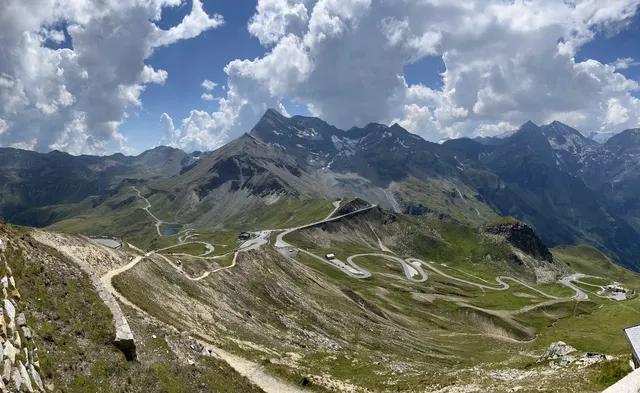
This road, which is one of the most beautiful in Europe, will have to reach road number 107, which partly includes the road. Exit Milstadt to the west toward Highway 100 and turn left onto Route 106. Continue on this road until Winklern City and take Route 107 north. The entrance to the Grossglockner road is paid, so you will have to go through a payment station before you leave. The Grossglockner road passes through the magnificent Austrian Alps and spreads over 48 kilometers. The opening hours of the road vary according to the season, around 6:00 to 18:00. It is recommended to refuel before starting, although it is not long, so that the situation will not happen in the middle of the road with an empty container. It is also recommended to have warm clothes, as you are about to pass through the Austrian Alps and the cold is great.

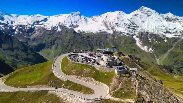
On the way, it is recommended to stop at the Kaiser-Franz-Josefs-Höhe visitor center, located at the highest point of the road, at a height of about 2570 meters, and enjoy the stunning view, which includes the mountain named after the road - Grossglockner, 3,800 meters. At the visitors' center you can stop for a rest and a snack. The journey from Milstadt to the end of Route 107 is about two hours.

The Grossglockner road is only open from May to October and during bad weather, so if you come to the area when it's closed or if you just do not feel like going through this scenic road, there's another option to go north. Travel from Milstadt to Mallnitz-Obervellach, about half an hour's drive, and from there take a train to Bad Gastein. The train operates about 9 times a day and the journey takes about 15 minutes. When you arrive at Bad Gastein, you can pick up a new rental car and continue on...

   Read more
avatar
5.0
4y

Traveled here almost two decades ago now on one of my European vacations. Still this location stands out as a highlight of those travels. Enjoy views of a glacier even in the summer months! The views are spectacular. Enjoy the summer sun, mountain views, and perhaps a reminder of Christmas all in one stop. I recall well marked roads and a conveniently located parking garage. The walk to an observation area was close by. The highlight is taking in the view. In addition to taking in the majestic mountain view, there was the possibility to get refreshments and souvenirs. Some tourists were hiking into the valley and enjoying sports on the glacier so this could also be a potential vacation destination. We stopped by for maybe an hour or two while traveling between cities. The detour was well worth it and certainly a stop I would recommend adding to your itinerary. I recall the road collecting tolls just be prepared. In the summer all was in excellent condition but I can imagine these passages, as with all mountainous terrain, is likely to be hazardous during inclement weather especially in winter. Overall terrific spot! I highly recommend it for a 1-2 hour stop on your trip for family friendly sights seeing and a great opportunity for picnicking with a view, with the possibility of spending more time for the athletically inclined to hike onto and around...

   Read more
Page 1 of 7
Previous
Next

Posts

Pavel SolinPavel Solin
To make it clear right away, the three stars are not for the mountain itself which is incredibly beautiful. They are for the overall experience which was tainted by the congestion, peoples' behavior, and trail safety which is inadequate in view of the mass traffic. Most other reviews won't prepare you for what to really expect, so let me give you a glimpse. We did this hike with a friend at the end of June 2025. From the Adlersruhe hut, the trail crosses a moderately steep snow field. The introductory via ferrata ends in a steep rock section where the trail is poorly marked. We were not the only ones pondering which way to go up. Apparently, we scrambled a bit too much to the right, because we ended up climbing through bare rock and pristine snow and ice. Being experienced climbers, this was not a big deal, and we even enjoyed it. But adding a few trail markers at the end of the first via ferrata would certainly help. More importantly, the trail is mostly steep, narrow, and exposed, and there are numerous bottlenecks that cause congestion on a regular basis. We witnessed people being rude, reckless, and even outright dangerous. Be ready for a constant stream of hikers coming at you from the opposite direction, unwilling to slow down. If you want to take a picture, people behind you will try to pass you instantly. We were yelled at (in Polish) for taking some 10 seconds to snap a photo. The trail itself is rather poorly secured. This would not be a problem if there were fewer people, as the whole stress is caused by the heavy traffic. With a few exceptions, there are no fixed ropes. Instead, there are steel poles, perhaps 1 - 1.5 meters tall, located some 10-20 meters apart. At one moment, I was anchored with a sling to one of them with eight (8) other people. Some going up, some going down, everybody anxious to go. One lady disconnected herself from the safety pole and started climbing up away from the official route with no protection. I witnessed several guided groups where the customers went down steep exposed sections, followed by a guide who was at the end of their rope, unprotected. He would not be able to arrest anybody if they slipped and fell. Safety is overrated. I seriously wonder how the reported number of deaths on the Grossglockner is only 2 per year, as this is a disaster in waiting. On the way down, we sometimes chose to lower ourselves on the miscellaneous bolts to circumvent the heavy traffic and for our own safety.
Vanja ZvonarVanja Zvonar
Grossglockner, the one and only. Top of Austria. Center of The Hohe Tauern National Park. A widely known name and symbol in alpinism. The second most prominent alpine peak and home to Austria's biggest glacier, Pasterze. The first documented ascent was made in 1802. Since then thousands of mountaineers have climbed it but many never made it back. Numerous trails lead to the mountain huts below the summit and just few dangerous trails lead to the summit. The ascent requires a high level of fitness, endurance, persistence and concentration as well as advanced alpine equipment. Starting from the usual points (e.g. Kals parking lot at Lucknerhaus - Studlhutte - Adlersruhe - Gg = 9.0 km) the ascent and descent usually take 2 days but they can be done in 1 day. An iron cross is installed on the summit with engravings denoting important moments in Austria's newer history. From the altitude of 3798 m.a.s.l. one can only enjoy the rugged beauty and purity of The Alps.
Thus Wurstbursch Kögl de Waldinutzy, Attaknabe (De x-träjm Soup man)Thus Wurstbursch Kögl de Waldinutzy, Attaknabe (De x-träjm Soup man)
Anfang Juni ist eine prima Zeit, den GG zu besteigen. Es liegt noch ordentlich Schnee, so dass man über die Gletscherspalten einfach per Schneeschuh herüberläuft. Und auf dem Gipfel ist wenig los: An unserem Tag waren außer uns sieben Leute oben. Wer die Schreckensbilder aus der Stoßzeit kennt, darf jetzt ruhig neidisch werden. Wir haben die Besteigung als Tagestour gemacht: 2000 Meter rauf und runter in knapp 12 Stunden. Morgens früh um vier ging es los. Schnell waren wir an der Lucknerhütte, und bald danach schnallten wir in die Schneeschuhe ein. Unterhalb der Adlersruhe wird es dann steil. Hier am Grat konnten wir die Schneeschuhe weglegen. Wir tauschten sie gegen die Eisen ein, und rauf ging's zur höchsten Hütte der Ostalpen: Zur Erzherzog-Johann-Hütte auf 3454 Metern. Es folgt das steile Glocknerleitl, der schmale Grat des Kleinglockners, und schließlich die gefürchtete Glocknerscharte zwischen Klein- und Großglockner. Das Glocknerleitl hinauf war kein Problem. Es heißt ja auch "Eisleitl", aber von Eis war keine Spur. Der Schnee war bestens, und wir kamen gut voran. Das gelbe Schild oben am Ausstieg steckte noch tief im Schnee. Der Grat war dann ziemlich schmal. Der für diese Jahreszeit ordentliche Schnee war zu einer richtigen Schneide zusammengeweht, und so war die Überschreitung des Kleinglockners ein Balanceakt. Wenn auch kein Vergleich zur Glocknerscharte. Hier war der Schneegrat so schmal, dass wir beim Querstehen sowohl Spitze wie auch Absatz in der Luft hatten. Vorsichtig ging's die die letzten Meter hinauf zum Gipfel. Was man von hier oben aus sehen kann? Na, alles - bis auf den Großglockner. Ist eben der höchste. Im Nordwesten Wilder Kaiser mit Scheffauer, Ellmauer Halt und Ackerlspitze, weit weg der Große Arber (!) dann Hochkalter, Watzmann, Großes Wiesbachhorn, Ankogel. Dann die Schobergruppe, ganz hinten der 116 Kilometer entfernte Triglav, näher die Dolos mit der Sextener Sonnenuhr mit Zehner, Elfer, Zwölfer und Einser, Antelao und Sorapiss, Paternkofel, den drei Zinnen, Monte Cristallo, den Tofanen, der Fanesgruppe mit dem Heiligkreuzkofel, Piz Boe, Rosengarten und Latemar. Noch näher die Villgratener Berge im Süden, mit Regenstein, Hochgrabe, Kugelwand, noch näher der Lasörling und die Gipfel des wunderbaren langen Kamms östlich des Lasörlings. Weiter weg die Brenta, und natürlich Königspitze, Zebru und Ortler. Im Westen prominent: Wildspitze, Säulkopf, der Großvenediger, (der geht übrigens auch als Tagestour), Olperer und Hoher Riffler, und weniger promenent der Hochvogel, der Thaneller und natürlich die Zugspitze. Tja, und dann ging's wieder hinunter.
See more posts
See more posts
hotel
Find your stay

Pet-friendly Hotels in Heiligenblut am Großglockner

Find a cozy hotel nearby and make it a full experience.

To make it clear right away, the three stars are not for the mountain itself which is incredibly beautiful. They are for the overall experience which was tainted by the congestion, peoples' behavior, and trail safety which is inadequate in view of the mass traffic. Most other reviews won't prepare you for what to really expect, so let me give you a glimpse. We did this hike with a friend at the end of June 2025. From the Adlersruhe hut, the trail crosses a moderately steep snow field. The introductory via ferrata ends in a steep rock section where the trail is poorly marked. We were not the only ones pondering which way to go up. Apparently, we scrambled a bit too much to the right, because we ended up climbing through bare rock and pristine snow and ice. Being experienced climbers, this was not a big deal, and we even enjoyed it. But adding a few trail markers at the end of the first via ferrata would certainly help. More importantly, the trail is mostly steep, narrow, and exposed, and there are numerous bottlenecks that cause congestion on a regular basis. We witnessed people being rude, reckless, and even outright dangerous. Be ready for a constant stream of hikers coming at you from the opposite direction, unwilling to slow down. If you want to take a picture, people behind you will try to pass you instantly. We were yelled at (in Polish) for taking some 10 seconds to snap a photo. The trail itself is rather poorly secured. This would not be a problem if there were fewer people, as the whole stress is caused by the heavy traffic. With a few exceptions, there are no fixed ropes. Instead, there are steel poles, perhaps 1 - 1.5 meters tall, located some 10-20 meters apart. At one moment, I was anchored with a sling to one of them with eight (8) other people. Some going up, some going down, everybody anxious to go. One lady disconnected herself from the safety pole and started climbing up away from the official route with no protection. I witnessed several guided groups where the customers went down steep exposed sections, followed by a guide who was at the end of their rope, unprotected. He would not be able to arrest anybody if they slipped and fell. Safety is overrated. I seriously wonder how the reported number of deaths on the Grossglockner is only 2 per year, as this is a disaster in waiting. On the way down, we sometimes chose to lower ourselves on the miscellaneous bolts to circumvent the heavy traffic and for our own safety.
Pavel Solin

Pavel Solin

hotel
Find your stay

Affordable Hotels in Heiligenblut am Großglockner

Find a cozy hotel nearby and make it a full experience.

Get the Appoverlay
Get the AppOne tap to find yournext favorite spots!
Grossglockner, the one and only. Top of Austria. Center of The Hohe Tauern National Park. A widely known name and symbol in alpinism. The second most prominent alpine peak and home to Austria's biggest glacier, Pasterze. The first documented ascent was made in 1802. Since then thousands of mountaineers have climbed it but many never made it back. Numerous trails lead to the mountain huts below the summit and just few dangerous trails lead to the summit. The ascent requires a high level of fitness, endurance, persistence and concentration as well as advanced alpine equipment. Starting from the usual points (e.g. Kals parking lot at Lucknerhaus - Studlhutte - Adlersruhe - Gg = 9.0 km) the ascent and descent usually take 2 days but they can be done in 1 day. An iron cross is installed on the summit with engravings denoting important moments in Austria's newer history. From the altitude of 3798 m.a.s.l. one can only enjoy the rugged beauty and purity of The Alps.
Vanja Zvonar

Vanja Zvonar

hotel
Find your stay

The Coolest Hotels You Haven't Heard Of (Yet)

Find a cozy hotel nearby and make it a full experience.

hotel
Find your stay

Trending Stays Worth the Hype in Heiligenblut am Großglockner

Find a cozy hotel nearby and make it a full experience.

Anfang Juni ist eine prima Zeit, den GG zu besteigen. Es liegt noch ordentlich Schnee, so dass man über die Gletscherspalten einfach per Schneeschuh herüberläuft. Und auf dem Gipfel ist wenig los: An unserem Tag waren außer uns sieben Leute oben. Wer die Schreckensbilder aus der Stoßzeit kennt, darf jetzt ruhig neidisch werden. Wir haben die Besteigung als Tagestour gemacht: 2000 Meter rauf und runter in knapp 12 Stunden. Morgens früh um vier ging es los. Schnell waren wir an der Lucknerhütte, und bald danach schnallten wir in die Schneeschuhe ein. Unterhalb der Adlersruhe wird es dann steil. Hier am Grat konnten wir die Schneeschuhe weglegen. Wir tauschten sie gegen die Eisen ein, und rauf ging's zur höchsten Hütte der Ostalpen: Zur Erzherzog-Johann-Hütte auf 3454 Metern. Es folgt das steile Glocknerleitl, der schmale Grat des Kleinglockners, und schließlich die gefürchtete Glocknerscharte zwischen Klein- und Großglockner. Das Glocknerleitl hinauf war kein Problem. Es heißt ja auch "Eisleitl", aber von Eis war keine Spur. Der Schnee war bestens, und wir kamen gut voran. Das gelbe Schild oben am Ausstieg steckte noch tief im Schnee. Der Grat war dann ziemlich schmal. Der für diese Jahreszeit ordentliche Schnee war zu einer richtigen Schneide zusammengeweht, und so war die Überschreitung des Kleinglockners ein Balanceakt. Wenn auch kein Vergleich zur Glocknerscharte. Hier war der Schneegrat so schmal, dass wir beim Querstehen sowohl Spitze wie auch Absatz in der Luft hatten. Vorsichtig ging's die die letzten Meter hinauf zum Gipfel. Was man von hier oben aus sehen kann? Na, alles - bis auf den Großglockner. Ist eben der höchste. Im Nordwesten Wilder Kaiser mit Scheffauer, Ellmauer Halt und Ackerlspitze, weit weg der Große Arber (!) dann Hochkalter, Watzmann, Großes Wiesbachhorn, Ankogel. Dann die Schobergruppe, ganz hinten der 116 Kilometer entfernte Triglav, näher die Dolos mit der Sextener Sonnenuhr mit Zehner, Elfer, Zwölfer und Einser, Antelao und Sorapiss, Paternkofel, den drei Zinnen, Monte Cristallo, den Tofanen, der Fanesgruppe mit dem Heiligkreuzkofel, Piz Boe, Rosengarten und Latemar. Noch näher die Villgratener Berge im Süden, mit Regenstein, Hochgrabe, Kugelwand, noch näher der Lasörling und die Gipfel des wunderbaren langen Kamms östlich des Lasörlings. Weiter weg die Brenta, und natürlich Königspitze, Zebru und Ortler. Im Westen prominent: Wildspitze, Säulkopf, der Großvenediger, (der geht übrigens auch als Tagestour), Olperer und Hoher Riffler, und weniger promenent der Hochvogel, der Thaneller und natürlich die Zugspitze. Tja, und dann ging's wieder hinunter.
Thus Wurstbursch Kögl de Waldinutzy, Attaknabe (De x-träjm Soup man)

Thus Wurstbursch Kögl de Waldinutzy, Attaknabe (De x-träjm Soup man)

See more posts
See more posts