Makgadikgadi Pans National Park presents one of the most visually and ecologically fascinating landscapes in Africa, and its map captures this uniqueness in bold strokes of emptiness punctuated by surprising lifelines. Located in northeastern Botswana, the park encompasses a portion of the greater Makgadikgadi salt pans—among the largest in the world. While the wider Makgadikgadi region includes both protected and unprotected areas, the National Park section specifically lies to the west of the pans, bordered in part by the Boteti River.
At first glance, the map reveals vast open spaces—much of it appearing as a blank canvas. This isn’t an error but a reflection of reality: these are ancient salt pans, remnants of a vast prehistoric lake. The pans dominate the eastern portion of the region, and within the National Park boundary, the map shows the Western edge of the Sua Pan and parts of the Ntwetwe Pan, with their flat, white expanses often resembling a moonscape on satellite imagery.
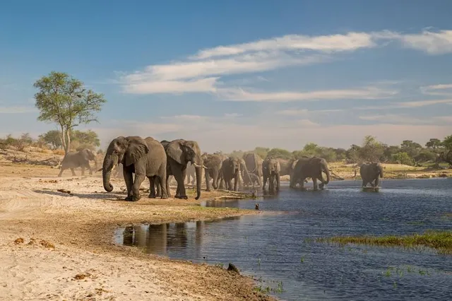
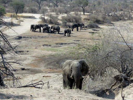
One of the most important geographical features on the map is the Boteti River, flowing along the park’s western boundary. This river is seasonal, but when in flow, it becomes the heartbeat of the park. The map marks its winding course, with associated lagoons and pools attracting herds of zebra, wildebeest, and antelope, especially in the dry season when animals migrate here from the salt flats. Points like Meno a Kwena, Khumaga Camp, and Tiaan’s Camp (just outside the official park boundary) are often highlighted as viewing bases along the river.
Roads on the map are sparse and rough, emphasizing the park’s wild nature. A few 4x4 tracks run from the Khumaga Gate in the west to other entry points like Phuduhudu Gate to the south. These are typically sand or salt-crusted tracks, with the main internal loop near the Boteti often being the only passable route during the rainy season. The dry pans, although seemingly empty, can become traps for the unwary driver after rain—and the map often includes advisory notations about seasonal access and vehicle requirements.
The map also marks designated wildlife-viewing areas near the river and some fossilized islands in the pans, such as Njuca Hills and Kubu Island (although the latter technically lies outside the park in a community-managed zone, it’s often included in broader Makgadikgadi maps due to its cultural and scenic significance).
Key features included on a quality map of the park would be:
Camping areas (e.g., Khumaga Camp inside the park and community camps just outside)
Vehicle routes and 4x4 trails
Seasonal waterholes
Wildlife migration corridors
Gates and park boundaries
Fauna is not specifically marked on the map, but informed travelers know that the Makgadikgadi zebra migration, one of Africa’s largest and least-known, travels seasonally between the pans and the river—driven by rainfall and grass growth. During the rainy season (November–April), the pans become shallow lakes, attracting thousands of flamingos and other migratory birds. The map’s elevation and water flow indicators can help pinpoint these transformation zones.
In conclusion, the map of Makgadikgadi Pans National Park is a guide to extremes—dry vs. wet, silence vs. seasonal abundance, and desolation vs. sudden, explosive life. It’s a map not of dense infrastructure or tourist stops, but of time, space, and nature’s slow drama, unfolding across an ancient salt-encrusted desert. It’s a place where the journey is as significant as the destination—and the map...
Read moreMakgadikgadi Pans National Park comprises nutritious grasslands, attracting thousands of animals. It is, however, an area of low rainfall and the Boteti River rarely flows to capacity - but often has everlasting pools that attracts waterbuck, bushbuck and hippos.
Journeying into this magical land and across the desolate pans, you will somehow feel its ancient glamour. If you’re planning a Botswana safari - a traveler's guide to the Makgadikgadi Pans National Park is definitely what you need. The best time to visit the Makgadikgadi Pans National Park, depends on the kind of experience you’re looking for. The pans itself is only accessible during the dry season - from March to October. When the glaring white surface spreads so far that you can see the curvature of the earth. This season includes peak winter days with sunny and warm daylight hours, but the nights are extremely cold. However, from August to November - windy weather sets in, with October being the hottest month - the wildebeest and herd of zebra migrates slowly towards the Boteti River in anticipation of the rains.
Meanwhile, the wet summer season of November to March. Road become impossible - but the Pans usually retain water into April or May. Which is great for birding and game watching. Games such as springbok, gemsbok, wildebeest and zebras move slowly from the pans in the South East of the park, to the Boteti River on the Western side of the park. Animals accumulate in their thousands during this migration - one can also see shy antelope such as duiker and bushbuck in heavily wooded areas beside the river.
The main objective in visiting the Makgadikgadi National Park is not to view games only, but to experience true remoteness and absolute isolation. However, the best way to view the pans during this season is to fly over the pans. You will then also see the spectacular flamingo flocks.
The sheets of water that cover the northeastern section of the Makgadikgadi during the first few months of wetter years attract a phenomenal marvel of water birds. The arrival of this water stimulates the birth of millions of tiny shrimps and other crustaceans otherwise lying dormant below the white salt crust. Greater and Lesser flamingos arrive, even journeying from as far off as the Great Rift Valley in East Africa to partake in one of Africa’s largest avian feasts. From a helicopter, the flamingos appear as enormous pink clouds in a shimmering silver sky. Helicopter flights over the flamingos are run by Helicopter Horizons and can be organized through San Camp, Jacks Camp and other accommodation options in the area. This is a...
Read moreAfter a few long days of game viewing driving in the Khwai/Moremi areas we decided on some quiet days here, we’ll pass on heading to the salt pans. We didn't expect particularly good game viewing along the Bo-teti river but we'd just do that. We entered one afternoon around 2pm, after dropping some tables and chairs at our SKL Khumaga campsite we set off along the river bank. And what an afternoon. A long drought for Botswana left the Boteti dry apart from a few remaining waterholes along the river. Everything was either heading to or from water. Thousands of zebra, as many wildebeest, impala, kudu and giraffe. And elephants. Down on the river bed more than 200 spread over a 15km drive. And when on the banks curving in the sand track there seemed an elephant behind every bush either coming or going to the river. The following morning, same animals but only 10% of the volume of the previous afternoon and few ele-phant. But again by 2.30 pm literally a few thousand animals covering the dry riverbed,...
Read more