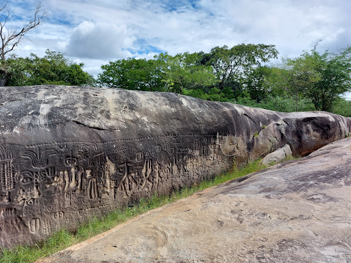
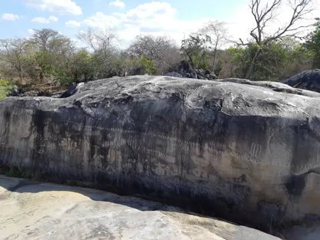
The Ingá Stone is located in the middle of the Ingá River in the small Brazilian city of Ingá (know you know how it got its name). What is it? It’s a rock formation that is covered with petroglyphs (or stone picture carvings). The prehistoric carvings were done over time and the most recent additions may have been added as recently as the 18th Century—all done by local native tribes. The meaning and/or purpose of these carvings is unknown and undeciphered. Some of the carvings resemble animals, fruits, the Orion Constellation and other less-easily distinguishable figures. The carvings are also known as the Itacoatiara do Ingá (pronounced: “EEta- cwa – tiara”), which is the name in the Tupi language of the original natives. “Ita” means stone and “coatiara” means picture. This is not the only such site with carvings in this part of Brazil, but it is one of the biggest. Still, when we visited, there was nobody here. The northeast of Brazil is less-visited by tourists than the south; this site sits 100 kilometers (60 miles) from the capital of the state, so that also contributes to the lack of tourism, but that’s good for you if you do go! To get there, the roads aren’t bad and you can find it on your Waze or Google Maps. I was really impressed with this site and I was very glad I visited. If you’re anywhere near here, you really...
Read moreBeautiful stone with well preserved petrogplyphs from the indiginous people. The stone is a bit in the middle of no where and when we visited we were the only people. There is a total of four places were you can clearly see petroglyphs. The main stone carving resembles a flood with a wave, followed by plants, palms and people. Some stone carvings also seem to represent stars. The site also has an information panel and many trees/plants have an information sign explaining what the plant is. There is also a small museum with an entrance of 5 real. Overall, really worth visiting this archeoligical site. The entrance is surprisingly free and the access road is in good conditions. The walking path to and around the Ingá stone are in good condition but some places might be difficult to walk for...
Read moreA Pedra do Ingá é um monumento arqueológico, identificado como "itacoatiara", constituído por um terreno rochoso que possui inscrições rupestres entalhadas na rocha, localizado no município brasileiro de Ingá no estado da Paraíba.[1] O termo "itacoatiara" vem da língua tupi: itá ("pedra") e kûatiara ("riscada" ou "pintada"). De acordo com a tradição, quando os indígenas potiguaras, que habitavam a região, foram indagados pelos colonizadores europeus sobre o que significavam os sinais inscritos na rocha, usaram esse termo para se referir aos mesmos. A formação rochosa em gnaisse cobre uma área de cerca de 250 m². No seu conjunto principal, um paredão vertical de 50 metros de comprimento por 3 metros de altura, e nas áreas adjacentes, há inúmeras inscrições cujos significados ainda são desconhecidos. Neste conjunto estão entalhadas figuras diversas, que sugerem a representação de animais, frutas, humanos e constelações como a de Órion. O sítio arqueológico fica a 109 km de João Pessoa e a 38 km de Campina Grande. O acesso ao local se dá pela BR 230, onde há uma entrada para a PB 90, na qual após percorrer 4,5 km chega-se ao núcleo urbano de Ingá. Atravessando a avenida principal da cidade, percorrem-se mais 5 km por estrada asfaltada até se chegar ao Sítio Arqueológico da Pedra do Ingá. No local há um prédio de apoio aos visitantes e as instalações de um museu de História Natural, com vários fósseis e utensílios líticos encontrados na região onde hoje fica a cidade. O sítio arqueológico está numa área, outrora privada, que foi doada ao Governo Federal brasileiro e posteriormente tombada como Monumento Nacional pelo extinto Serviço do Patrimônio Histórico e Artístico Nacional (atual IPHAN), a 30 de novembro de...
Read more