My Honest Review of the Teva I Uta Jungle Hike
Total Distance: 18 km round-trip (11.2 miles)
Total Time: ~6-6.5 hours (with stops, kids in tow and detours)
Trail Type: Out-and-back
Start Point: School soccer field at Plus Code 7J3V+9QG, Teva I Uta
TL;DR: We thought we were hiking to Lake Vaihiria. We weren’t. But what we found was still wild, beautiful, and worth it — if you’re prepared to get a little lost, muddy, and sore.
Starting Off
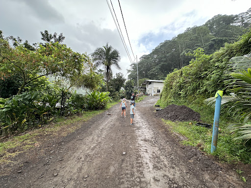
We parked at a school soccer field in Teva I Uta (Plus Code 7J3V+9QG) with almost zero real info about where we were headed. The reviews online were vague and inconsistent — some mentioned Lake Vaihiria, others mentioned waterfalls. So we just went for it.
As you head up the road from the parking area:
• You’ll pass a quarry, then hit a locked gate — walk around it.
• Soon after, there’s a pig farm down on the left (fun surprise, but a very real landmark).
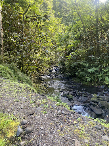
• A little further in, you hit a river crossing that’s part of the main trail — shallow and fun for kids. Honestly, if you’ve got very young children, this is probably the place to stop and play. After that, the trail changes vibe.
Getting Deep Into It
Beyond the first river crossing, the trail gets a lot more rugged — swampy puddles, mosquitoes, and some parts where you’re walking through stagnant water. There are also a couple beautiful spots where fresh waterfall water runs across the trail, and we stopped to cool off — that felt amazing.
Eventually, you’ll come to a fork in the trail. This part was confusing:
• We stayed left on the main trail, which stays on the left side of the river.
• There’s a path to the right that requires a second river crossing, and from what we saw, this might lead to more waterfalls. I say might because we didn’t take it — but two local guys who left the reservoir 45 minutes before us popped out of that right-hand trail just ahead of us on the way down. So I’m guessing that loop is longer, scenic, and possibly passes some falls.
The Final Push
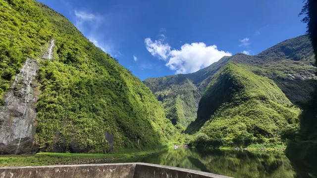
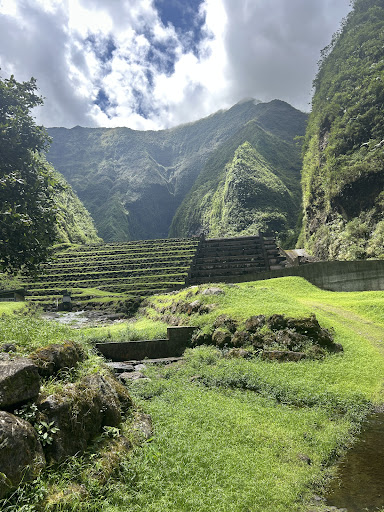
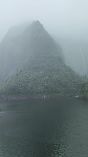
If you stay left like we did, you’ll eventually reach a buzzing hydroelectric shed with loud electrical humming and a ton of “DANGER” and “ACCESS INTERDIT” signs. We kept going — and about 45 minutes to an hour later, we arrived at a dammed reservoir tucked into the mountains.
It was stunning — sheer cliffs, green water, and waterfalls in every direction. But this is definitely not Lake Vaihiria.
Important Stuff I Wish I Knew
• This trail does not go to Lake Vaihiria. The place we reached is a lower-elevation reservoir, likely part of the same watershed.
• You cannot swim in the reservoir — it’s clearly part of an active water system.
• The alternate trail (across the river at the fork) probably leads to more scenic spots and waterfalls — but I’m not promising that, since we didn’t confirm it ourselves.
• Trail is not marked at all — no signs, no reassurance. If you don’t know what to expect, it can feel like you’re lost.
• It gets rough: lots of bugs, slippery footing, and overgrowth. Bring good shoes, bug spray, and plenty of water.
• There are no bathrooms, no trash bins, no water stations — just nature and whatever you bring with you.
Final Thoughts
This hike surprised me. We started not knowing where we were going, and even though we didn’t end up at Lake Vaihiria like we thought, the journey was honestly still worth it.
You’ll pass farms, cross rivers, wonder if you’re on the right path, and eventually land at a beautiful, remote reservoir surrounded by waterfalls and jungle cliffs.
Would I do it again? Yes — but next time I’m taking that right-hand fork at the river and seeing where it really goes.
If you’re looking for a polished trail with signage, this isn’t it. But if you’re craving a real, wild, unpredictable jungle hike — this...
Read more