HTML SitemapExplore
Find Things to DoFind The Best Restaurants

Kalipso waterfall — Attraction in Agia Municipality

Name
Kalipso waterfall
Description
Nearby attractions
Nearby restaurants
Nearby hotels
Related posts
Keywords
Kalipso waterfall tourism.Kalipso waterfall hotels.Kalipso waterfall bed and breakfast. flights to Kalipso waterfall.Kalipso waterfall attractions.Kalipso waterfall restaurants.Kalipso waterfall travel.Kalipso waterfall travel guide.Kalipso waterfall travel blog.Kalipso waterfall pictures.Kalipso waterfall photos.Kalipso waterfall travel tips.Kalipso waterfall maps.Kalipso waterfall things to do.
Kalipso waterfall things to do, attractions, restaurants, events info and trip planning
Kalipso waterfall
GreeceThessaly and Central GreeceAgia MunicipalityKalipso waterfall

Basic Info

Kalipso waterfall

Melivoia 400 03, Greece
4.5(222)
Open 24 hours
Save
spot

Ratings & Description

Info

Outdoor
Adventure
Scenic
Off the beaten path
attractions: , restaurants:
logoLearn more insights from Wanderboat AI.

Plan your stay

hotel
Pet-friendly Hotels in Agia Municipality
Find a cozy hotel nearby and make it a full experience.
hotel
Affordable Hotels in Agia Municipality
Find a cozy hotel nearby and make it a full experience.
hotel
The Coolest Hotels You Haven't Heard Of (Yet)
Find a cozy hotel nearby and make it a full experience.
hotel
Trending Stays Worth the Hype in Agia Municipality
Find a cozy hotel nearby and make it a full experience.

Reviews

Get the Appoverlay
Get the AppOne tap to find yournext favorite spots!
Wanderboat LogoWanderboat

Your everyday Al companion for getaway ideas

CompanyAbout Us
InformationAI Trip PlannerSitemap
SocialXInstagramTiktokLinkedin
LegalTerms of ServicePrivacy Policy

Get the app

© 2025 Wanderboat. All rights reserved.

Reviews of Kalipso waterfall

4.5
(222)
avatar
4.0
15w

Started the trek at the fork in the road - the point where if facing to the sea, you go left to Kokkolino Nero and right to the beach. From there, you leave your car at a dirt parking and make your way towards the red and yellow markings. The trail is a very steep climb 85-90 percent of time, a total elevation of around 450 meters form the said starting point. GOOD: the trail is marked very well with a red sqaure and a yellow square inside it 🟥🟨 on tree trunks and boulders. In the last section of the climb, blue arrows show you were to step - excellent and thoughtful. The views of the see and the vertical gorge walls are dramatic, with lots of cyclamen flowers all around. The water in the pool near the waterfall itself is crystal clear and freezing - exactly what you need after you finish climbing.

BAD: at this time of the year, the waterfall is reduced to a mere trickle. To make the things even worse, someone (I guess local farmers) draws water from the top of the waterfall in many black rubber hoses. It also spoils the view along the hike, as you constantly see ugly hoses and water fittings while you climb up. All in all, I guess the trail deserves a perfect five stars mark in the beginning of the summer, June-July. While not extreme, the hike does need more than...

   Read more
avatar
5.0
2y

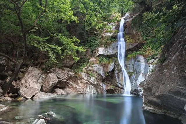
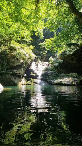
Absolutnie najpiękniejsze miejsce wokół Kokkino Nero dostępne dla podróżujących na piechotę. Krystalicznie czysta woda, widoki na całe wybrzeże, urokliwe skałki, jeziorko, w którym można się schłodzić. Bardzo polecam wejść jak najwyżej się da z pomocą lin i uchwytów!

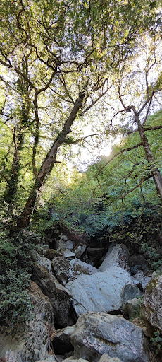
Na wodospad wybraliśmy się grupą 16 studentów i 4 opiekunów. W większości amatorzy górskiej wspinaczki bez większych problemów poradzili sobie z trasą w zwykłych adidasach, krótkich spodenkach i t-shirtach. Mieliśmy kilku weteranów, którzy pomagali w trudniejszych miejscach gdzie można było się poślizgnąć, zjechać na kamienistym zboczu czy zeskoczyć z wysokości około 0,5-1 metr. Trasę oceniam na średnio trudną. Biorę poprawkę na to, że udział w wyprawie brały osoby w sile wieku- 18 lat.

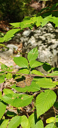
Czerwony szlak turystyczny bierze swój początek za atrakcją zwaną "Oko Zeusa". Jest dość dobrze oznaczony ale nie ma standardowych dla Polski lub innych krajów tabliczek z odległością i celem podróży. Znaleźć można tylko czerwone tabliczki wskazujące na kolor szlaku. Sami musimy się domyślić gdzie prowadzi 😛 Trasa od centrum Kokkino Nero zabrała Nam poniżej 3 godzin. Mimo tego co pisałem wcześniej polecam dobre buty i koniecznie długie spodnie! Grecka flora na każdym kroku próbuje Cię zatrzymać, podrapać, pokłuć lub poparzyć. Szlak jest rzadko uczęszczany więc rośliny cały czas krzyżują drogę. Jeśli nie jesteś pewny trasy polecam odszukać mapę na aplikacji AllTrails. Są na niej zaznaczone wszystkie leśne ścieżki i łatwiej można się rozeznać w terenie. Polecam także rzut satelitarny z Google Maps. Pokazuje więcej niż standardowy widok.

Trasę powrotną od wodospadu przeszliśmy w innym miejscu. Kierując się drogą na północ zeszliśmy na ścieżkę pomiędzy polami. Jest bardziej stroma i jest wysypana małymi kamyczkami, które powodują, że większość z Nas cały czas się na nich ślizgała. Musieliśmy wzajemnie się asekurować żeby nie zjechać niebezpiecznie w dół. Ścieżka kończy się na trasie przy samym wejściu na Oko Zeusa. Stojąc na asfalcie i patrząc na znak nie należy schodzić w lewo tylko w górę w prawo. To informacja dla tych, którzy nie lubią iść tą samą ścieżką w obie strony 😉 Po wycieczce zdecydowałbym się tę drogę pokonać w górę a zejść czerwonym szlakiem. Byłoby dużo łatwiej. Jak nie interesuje Cię wyzwanie, wolisz zacienioną ścieżkę wśród drzew to polecam w obie strony iść tą samą drogą.

Pozdrawiam uczniów i nauczycieli Szkół Technicznych ze Szczucina i Rawy...

   Read more
avatar
5.0
1y

Ci siamo stati la seconda settimana di agosto e la cascata aveva una portata minima ma il luogo è davvero incantato, quasi magico e puoi fare un bellissimo bagno e nuotare nelle fresche acque attorniato da una vegetazione stupenda. Poiché era pomeriggio tardo e tutti erano già andati via abbiamo trascorso quasi tutto il tempo senza nessun altro, con il sole che filtrava tra i rami degli alberi. Ci siamo arrivati con qualche difficoltà nel trovare la strada giusta ma poi, viste alcune recensioni che parlavano del percorso in modo contrastante, abbiamo capito che le cascate potevano essere raggiunte in 2 modi, uno dall'alto, seguendo Google Map con l'impostazione delle cascate stesse e uno dal basso, seguendo per la Kalipso gorge. Pensando che l' accesso fosse più facile da sotto abbiamo scelto di deviare sullo sterrato con l' indicazione per la gola ma una volta arrivati dove la gola inizia, data l'assenza di cartelli che confermavano l'esattezza del percorso, abbiamo parcheggiato l' auto e continuato a piedi, sempre lungo la strada, cercando un sentiero che risalisse il pendio. In realtà bastava continuare per poco e passata la curva, dopo il tornante, la strada si allargava nuovamente. Lì vi era un motorino (e si può tranquillamente parcheggiare anche più di un'auto) e finalmente abbiamo trovato le indicazioni. Il sentiero che inizialmente sale poi si biforca e proseguendo verso destra ritorna verso la gola e poi scende per un breve tratto in mezzo a dei grossi massi verso la bellissima pozza con le cascate. L' accesso da sopra, come ci hanno confermato dei ragazzi che abbiamo incontrato, è molto più difficile e la discesa verso la cascata avviene con una corda e può...

   Read more
Page 1 of 7
Previous
Next

Posts

Asaf SchneiderAsaf Schneider
Started the trek at the fork in the road - the point where if facing to the sea, you go left to Kokkolino Nero and right to the beach. From there, you leave your car at a dirt parking and make your way towards the red and yellow markings. The trail is a very steep climb 85-90 percent of time, a total elevation of around 450 meters form the said starting point. GOOD: the trail is marked very well with a red sqaure and a yellow square inside it 🟥🟨 on tree trunks and boulders. In the last section of the climb, blue arrows show you were to step - excellent and thoughtful. The views of the see and the vertical gorge walls are dramatic, with lots of cyclamen flowers all around. The water in the pool near the waterfall itself is crystal clear and freezing - exactly what you need after you finish climbing. BAD: at this time of the year, the waterfall is reduced to a mere trickle. To make the things even worse, someone (I guess local farmers) draws water from the top of the waterfall in many black rubber hoses. It also spoils the view along the hike, as you constantly see ugly hoses and water fittings while you climb up. All in all, I guess the trail deserves a perfect five stars mark in the beginning of the summer, June-July. While not extreme, the hike does need more than basic fitness.
Luciana VendittiLuciana Venditti
Ci siamo stati la seconda settimana di agosto e la cascata aveva una portata minima ma il luogo è davvero incantato, quasi magico e puoi fare un bellissimo bagno e nuotare nelle fresche acque attorniato da una vegetazione stupenda. Poiché era pomeriggio tardo e tutti erano già andati via abbiamo trascorso quasi tutto il tempo senza nessun altro, con il sole che filtrava tra i rami degli alberi. Ci siamo arrivati con qualche difficoltà nel trovare la strada giusta ma poi, viste alcune recensioni che parlavano del percorso in modo contrastante, abbiamo capito che le cascate potevano essere raggiunte in 2 modi, uno dall'alto, seguendo Google Map con l'impostazione delle cascate stesse e uno dal basso, seguendo per la Kalipso gorge. Pensando che l' accesso fosse più facile da sotto abbiamo scelto di deviare sullo sterrato con l' indicazione per la gola ma una volta arrivati dove la gola inizia, data l'assenza di cartelli che confermavano l'esattezza del percorso, abbiamo parcheggiato l' auto e continuato a piedi, sempre lungo la strada, cercando un sentiero che risalisse il pendio. In realtà bastava continuare per poco e passata la curva, dopo il tornante, la strada si allargava nuovamente. Lì vi era un motorino (e si può tranquillamente parcheggiare anche più di un'auto) e finalmente abbiamo trovato le indicazioni. Il sentiero che inizialmente sale poi si biforca e proseguendo verso destra ritorna verso la gola e poi scende per un breve tratto in mezzo a dei grossi massi verso la bellissima pozza con le cascate. L' accesso da sopra, come ci hanno confermato dei ragazzi che abbiamo incontrato, è molto più difficile e la discesa verso la cascata avviene con una corda e può essere pericoloso.
Χριστοφορος ΔασκαλακηςΧριστοφορος Δασκαλακης
Ενα πραγματικά εντυπωσιακό σκηνικό στην ανατολική πλευρά του Κισσάβου προς τη θάλασσα. Μετά το χωριό Καρυτσα, στην κατεύθυνση προς Κόκκινο Νερό, στα δεξιά του δρόμου υπάρχει διασταύρωση με χωματόδρομο που οδηγεί προς το μονοπάτι για το φαράγγι της Καλυψούς και τον ομώνυμο καταρράκτη. Την εποχή που πήγα εγώ (μέσα Ιουνίου 25) ο χωματόδρομος είναι αρκετά βατός ακόμη καί για συμβατικό αυτοκίνητο, με λίγη προσεκτική οδήγηση. Στις διασταυρώσεις που θά συναντήσετε, ακολουθείτε τις μικρές μεταλλικές πινακίδες "Calypso canyon". Μετά από οδήγηση 2 περίπου χιλιομέτρων θα φτάσετε στο σημείο που ξεκινά τό μονοπάτι. Υπάρχει αρκετός χώρος νά αφήσετε το αυτοκίνητο σας. Το μονοπάτι έχει εξαιρετική σήμανση, ξεκινά σχετικά ομαλά, μέσα από καστανιές και στη συνέχεια αυξάνει αρκετά τον βαθμό δυσκολίας, ειδικά όσο προσεγγίζει τον καταρράκτη. Η απόσταση δεν είναι πάνω από χιλιόμετρο, ωστόσο υπολογίστε ότι θά χρειαστεί τουλάχιστον μισή ώρα για έναν μέσο περιπατητη και βέβαια αρκετό ιδρώτα. Ο τελικός προορισμός αποζημιώνει σίγουρα καθώς το μέρος μοιάζει μαγικό πραγματικά! Μέχρι και τέλος Ιουνίου η ποσότητα του νερού είναι ικανοποιητική, από εκεί καί ύστερα λιγοστεύει αρκετά. Σε κάθε περίπτωση είναι μια διαδρομή που αξίζει να την κάνετε,αν βρεθείτε στήν περιοχή!
See more posts
See more posts
hotel
Find your stay

Pet-friendly Hotels in Agia Municipality

Find a cozy hotel nearby and make it a full experience.

Started the trek at the fork in the road - the point where if facing to the sea, you go left to Kokkolino Nero and right to the beach. From there, you leave your car at a dirt parking and make your way towards the red and yellow markings. The trail is a very steep climb 85-90 percent of time, a total elevation of around 450 meters form the said starting point. GOOD: the trail is marked very well with a red sqaure and a yellow square inside it 🟥🟨 on tree trunks and boulders. In the last section of the climb, blue arrows show you were to step - excellent and thoughtful. The views of the see and the vertical gorge walls are dramatic, with lots of cyclamen flowers all around. The water in the pool near the waterfall itself is crystal clear and freezing - exactly what you need after you finish climbing. BAD: at this time of the year, the waterfall is reduced to a mere trickle. To make the things even worse, someone (I guess local farmers) draws water from the top of the waterfall in many black rubber hoses. It also spoils the view along the hike, as you constantly see ugly hoses and water fittings while you climb up. All in all, I guess the trail deserves a perfect five stars mark in the beginning of the summer, June-July. While not extreme, the hike does need more than basic fitness.
Asaf Schneider

Asaf Schneider

hotel
Find your stay

Affordable Hotels in Agia Municipality

Find a cozy hotel nearby and make it a full experience.

Get the Appoverlay
Get the AppOne tap to find yournext favorite spots!
Ci siamo stati la seconda settimana di agosto e la cascata aveva una portata minima ma il luogo è davvero incantato, quasi magico e puoi fare un bellissimo bagno e nuotare nelle fresche acque attorniato da una vegetazione stupenda. Poiché era pomeriggio tardo e tutti erano già andati via abbiamo trascorso quasi tutto il tempo senza nessun altro, con il sole che filtrava tra i rami degli alberi. Ci siamo arrivati con qualche difficoltà nel trovare la strada giusta ma poi, viste alcune recensioni che parlavano del percorso in modo contrastante, abbiamo capito che le cascate potevano essere raggiunte in 2 modi, uno dall'alto, seguendo Google Map con l'impostazione delle cascate stesse e uno dal basso, seguendo per la Kalipso gorge. Pensando che l' accesso fosse più facile da sotto abbiamo scelto di deviare sullo sterrato con l' indicazione per la gola ma una volta arrivati dove la gola inizia, data l'assenza di cartelli che confermavano l'esattezza del percorso, abbiamo parcheggiato l' auto e continuato a piedi, sempre lungo la strada, cercando un sentiero che risalisse il pendio. In realtà bastava continuare per poco e passata la curva, dopo il tornante, la strada si allargava nuovamente. Lì vi era un motorino (e si può tranquillamente parcheggiare anche più di un'auto) e finalmente abbiamo trovato le indicazioni. Il sentiero che inizialmente sale poi si biforca e proseguendo verso destra ritorna verso la gola e poi scende per un breve tratto in mezzo a dei grossi massi verso la bellissima pozza con le cascate. L' accesso da sopra, come ci hanno confermato dei ragazzi che abbiamo incontrato, è molto più difficile e la discesa verso la cascata avviene con una corda e può essere pericoloso.
Luciana Venditti

Luciana Venditti

hotel
Find your stay

The Coolest Hotels You Haven't Heard Of (Yet)

Find a cozy hotel nearby and make it a full experience.

hotel
Find your stay

Trending Stays Worth the Hype in Agia Municipality

Find a cozy hotel nearby and make it a full experience.

Ενα πραγματικά εντυπωσιακό σκηνικό στην ανατολική πλευρά του Κισσάβου προς τη θάλασσα. Μετά το χωριό Καρυτσα, στην κατεύθυνση προς Κόκκινο Νερό, στα δεξιά του δρόμου υπάρχει διασταύρωση με χωματόδρομο που οδηγεί προς το μονοπάτι για το φαράγγι της Καλυψούς και τον ομώνυμο καταρράκτη. Την εποχή που πήγα εγώ (μέσα Ιουνίου 25) ο χωματόδρομος είναι αρκετά βατός ακόμη καί για συμβατικό αυτοκίνητο, με λίγη προσεκτική οδήγηση. Στις διασταυρώσεις που θά συναντήσετε, ακολουθείτε τις μικρές μεταλλικές πινακίδες "Calypso canyon". Μετά από οδήγηση 2 περίπου χιλιομέτρων θα φτάσετε στο σημείο που ξεκινά τό μονοπάτι. Υπάρχει αρκετός χώρος νά αφήσετε το αυτοκίνητο σας. Το μονοπάτι έχει εξαιρετική σήμανση, ξεκινά σχετικά ομαλά, μέσα από καστανιές και στη συνέχεια αυξάνει αρκετά τον βαθμό δυσκολίας, ειδικά όσο προσεγγίζει τον καταρράκτη. Η απόσταση δεν είναι πάνω από χιλιόμετρο, ωστόσο υπολογίστε ότι θά χρειαστεί τουλάχιστον μισή ώρα για έναν μέσο περιπατητη και βέβαια αρκετό ιδρώτα. Ο τελικός προορισμός αποζημιώνει σίγουρα καθώς το μέρος μοιάζει μαγικό πραγματικά! Μέχρι και τέλος Ιουνίου η ποσότητα του νερού είναι ικανοποιητική, από εκεί καί ύστερα λιγοστεύει αρκετά. Σε κάθε περίπτωση είναι μια διαδρομή που αξίζει να την κάνετε,αν βρεθείτε στήν περιοχή!
Χριστοφορος Δασκαλακης

Χριστοφορος Δασκαλακης

See more posts
See more posts