Namdapha National Park - a global biodiversity hot spot in a threshold of
desolation??
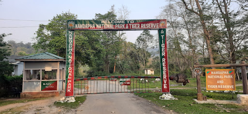
The Namdapha National Park in the Changlang district of Arunachal Pradesh is one of the relatively unexplored protected areas (PAs) harbouring rich plant diversity apart from its unique character as a Tiger Reserve (TR).
Namdapha National Park (27°23'30" - 27°39'40" N to 96°15'2" - 96°58'33" E) is located in the Changlang district of Arunachal Pradesh state in the easternmost corner of India. The total park area is 1985 sq km, of which 177 sq km is buffer zone and remaining 1808 sq km is the core zone. The park lies within the IndoMyanmar global biodiversity hotspot at the junction of the Palaearctic and Malayan bio-geographic realms resulting in a highly diverse species assemblage.
The area was originally ‘Reserved Forest’ and was declared as Wildlife Sanctuary in 1972 under Assam Forest Regulation. It was declared a ‘National Park’ in 1983. In the same year, it was declared a ‘Tiger Reserve’ under the Project Tiger scheme of Government of India. An area of 177 sq km of Reserved forest was added to the Tiger Reserve in 1986
*It’s Flora
The altitudinal variations along with the heavy rainfall it receives has made Namdapha congenial for 1000 plant species. The National Park harbours extensive dipterocarp forests, the northernmost lowland tropical rainforests in the world. With increasing elevation, there is a transition in habitat from subtropical broad-leaved forests to subtropical pine forests, temperate broadleaved forests, alpine meadows and perennial snow.
Though primary forests cover most of the park, there are extensive bamboo and secondary forests. The floral and faunal composition is highly similar to the adjoining forests in Myanmar and other parts of south-east Asia.
*The Wild Fauna
Ninety mammal species are reported from the park, including nine species of felids, two bear species, fifteen viverrid and mustelid species and seven primate species. Four species of mountain ungulates: red goral (Nemorhaedus baileyi), serow (Nemorhaedus sumatraensis), takin (Budorcas taxicolor) and musk deer (Moschus sp.) occur at higher elevations, while the hog deer (Axis porcinus) is restricted to the grassland habitat in the river valleys. The main species targeted by hunting are the Indian munjtjac (Muntiacus muntjak), sambar (Cervus unicolori), wild pig (Susscrofa) and gaur (Bos frontalis). These four species are among the important prey of the tiger, leopard (Panthera pardus) and the wild dog (Cuon alpines), while primates and smaller mammals constitute important prey for the clouded leopard.
Nearly 60 percent of Namdapha remains unexplored. The park continues to record new species: even tigers, though extremely rare, could possibly bounce back, given the large area.
However, although Namdapha is in a remote corner of the country, it could not escape from human interference.
*THREATS TO NAMDAPHA NATIONAL PARK
The existing threats to the National Park can be briefly summarised as follows:
(i) Human influx – In recent years, human migration caused by population increase has posed increasing threats to the biodiversity of forest zones all over the world. As has been mentioned earlier several ethnic human communities have been living in and around the park and are fully dependant on the resources of the national park for their day to day life. Besides the side-line settlements mentioned above, initially there were only two unauthorized settlements in the core zone with 43 households and a population of 280 as recorded in 2004, but now it has increased to twelve villages with around twothousands and growing population.
Prior to the declaration of Namdapha as a national park and tiger reserve, the Chakmas were living in Haldibari, Zero camp and Farmbase (present buffer zone). After declaration as a national park in 1983, they were resettled outside the park boundary in the adjacent Anchal reserve forests. However...
Read moreWe drove to Miao, Changlang District & reached Miao at 07:30pm. It's a small village of 17k population. We stayed at government circuit house. It's reasonably maintained.
In the morning at 09:00am, we started from Miao for Deban, one of spots, where there is only government settlement & establishments. It is situated far from even sparsely populated areas. We drove along with Noa-Dehing river for about 25 kms and reached Deban. It has trekking hostel and some guest-houses. We stayed in forest log-hut. Deban is situated on banks and at rendezvous of three rivers, viz. 1. Nao-Dehing(Nao-Dihing), 2. Namdapha, 3. Deban. It's a very wide width of meeting point. (Nao-Dehing ultimately merges with river Brahmputra.) It's a wonderful view. On other two sides, there are dense & virgin forests. On one of the sides, there is a trek for adventurists. Of course, this time it's not ready for trekking, because trek isn't made clear even for trekking. It's about 36 kms long trek. There are so many trekking points on the way.
I must say that I have visited so many forests since my childhood across the country & world I have not visited such virgin forest like Namdapha. Namdapha forest is very large forest on common border of Hindustan and Myanmar. It is such dense forest that no physical marking of border between the two countries, but there is imaginary line on the maps of both countries.
I am surprised to learn that elephant ride is available on payment to visit this forest. It took two hours. Two persons can be accommodated. I and my wife are here. We were taken to dense and virgin part of Namdapha forest crossing Nao-Dehing river. It was really very exciting experience. Our elephant-Vanraj is very young of 20 years old. Our Mahavat Hemant is also very young.
We started from Deban base camp at 12.15 pm and reached the forest within half an hour in the forest crossing all three rivers. We entered the forest from small slit opening. I felt my dream of visit such forest came true. It was time around 0100 pm we moved in the forest, but at some places darkness made us to believe that it was 0600 pm. We also came across various small and big springs, which were egger to meet river Nao-Dehing. I found tranquility in the forest, which is beyond my capacity of explaining it in words.
I am very much indebted to Justice AK Goel who inspired me to visit this forest and also RFOs Mr. H Tungkhang and Mr. Likha Obi, who made all the arrangement for my visit to Namdapha...
Read moreNamdapha National Park is the largest protected area in the Eastern Himalaya biodiversity hotspot and is located in Arunachal Pradesh in Northeast India. It is also the third largest national park in India in terms of area. It is located in the Eastern Himalayan sub-region and is recognized as one of the richest areas in biodiversity in India.1] The park harbours the northernmost lowland evergreen rainforests in the world at 27°N latitude.[2] The area is also known for extensive dipterocarp forests, comprising the northwestern parts of the ecoregion of Mizoram-Manipur-Kachin rain forests.Namdapha was originally declared a Wildlife Sanctuary in 1972, then a National Park in 1983 and became a Tiger Reserve under the Project Tiger scheme in the same year.[4] Its name was combination of two Singpho words "nam" means forest and "dapha" means keeping. When Singpho people were clearing the forest a man said that the jungle was very beautiful and it should not be cut down. So in this way it gets its name.The national park is located in Changlang district of the northeastern state of Arunachal Pradesh, near the international border with Myanmar. It spans an area of 1,985 km2 (766 sq mi) including a buffer zone of 177 km2 (68 sq mi) and a core area of 1,808 km2 (698 sq mi). It is located between the Dapha bum range of the Mishmi Hills and the Patkai range with a wide elevation range between 200 and 4,571 m (656 and 14,997 ft). It is crossed from east to west by the Noa Dihing River that originates at the Chaukan Pass, located on the Indo-Myanmar border. The land cover changes with increasing elevation from tropical evergreen forest to temperate broadleaf and mixed forest. Secondary forests cover 345.47 km2 (133.39 sq mi); seasonal snow occurs at above 2,700 m (8,900 ft) between December and March.[1 Additionally, the park has extensive bamboo forests.[citation needed] The area falls under both the Palearctic and Indo Malayan biogeographic areas resulting in a diverse...
Read more