Recently visited this place post 2nd lockdown. Vaccination reports are being checked. One dose atleast is compulsory. About the place.. there are two ways to reach the peak.. you can either take a jeep or trek. In jeep it's a 9km drive which will roughly take an hour or so to reach the peak due to the condition of the road which will take you till a temple, and then from there it's a 1.5 km hike to the peak, also called "sarvagna peeta". If you are trekking then there are two ways to reach the peak.. 1. Via Hindlumane falls ( I recommend ) 2. You trek in the jeep route. Via Hindlumane falls- so if you are trekking in this route the trek distance will be around 14km ( till sarvagna peeta ). Here you will be passing through a different checkpost and not the regular one on the jeep route. So why I recommend this is, once you start the trek you will be getting Hindlumane falls at around 4km where you can relax, take some rest spend some time in water infact freshen up then resume your trek. And the trails also is scenic after Hindlumane falls as it opens up from forest. Also it gets a little challenging if you are a beginner .. it's a mixed trail steep , less steep.. somewhere flat (little). As you climb you will reach a place called shooting spot ( one of the film was shot here - "Gaalipata" ). From here you join to the same jeep route and walk along the road till you reach the temple. Jeep route- you just climb the hill on the regular jeep road. Road condition is as apt for the 4x4 jeeps. It's not as that easy also as the road condition is bad. On the peak weather is very unpredictable most of the times covered with fog, light drizzles or rain anything is possible. View from the peak also depends on these weather conditions but you won't be disappointed. Supposedly if the day is clear on your trek day you will be able to see the Arabian sea from the peak ( I heard this not sure how far it's true ). Unfortunately the day I trekked it was completely covered in mist. Tips - Trekking & Jeep option is very flexible here. You can trek one side and come back in jeep. Or you can go up in jeep and trek back by foot. But if you are choosing to descend by foot be careful it gets little slippery if it's raining and also if you are descending via Hindlumane falls, it's risky since the places around the falls are rocks and very slippery and steep and might be little difficulty in getting down. Otherwise fine. And when you are climbing via Hindlumane falls and planning to give up .. just try to reach shooting spot because that's where you meet the road and you can arrange a jeep for yourself. Now cost- Trekking cost is 400rs per person. If you are taking jeep then I heard it is less. Not sure, apologies. They charge you for plastic bottles and covers, which is refundable. That is.. they enter the number of plastics you are carrying along with you charge for it and give you a receipt. On return if you show all the plastic you carried along, they refund the amount...
Read moreWith a light breakfast of yummy dosa, we kick started our trek towards the hill. We come across the fields with coastal crops like paddy, banana, coconut and betel nut that enchanted the forest. We start to climb the sloppy forest & I pick up my supporting character “the stick”. As we climb, at times we turned out to be a 4-limbed animal with high breathing rate. 
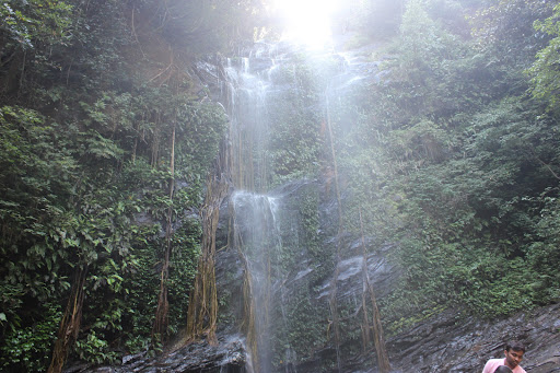
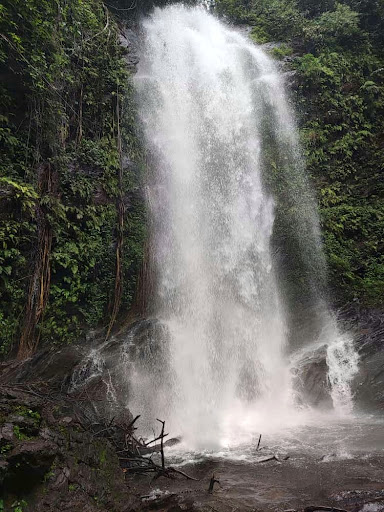
As we progress to our astonishment, we come across a streamlined water flow wondering its origin. As we proceed further, we see an alluring water flow with minimal noise. It was entitled as “Hidlumane” falls meaning, a waterfall behind home, which really looked like one with it’s a calm appearance. After few photo clicks, we climb fast to chase our guide (Local Guide is a must when we trek through a forest).
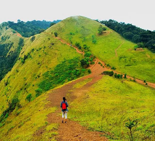
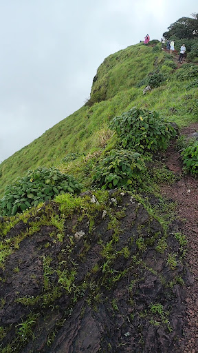
As we reached the 2nd hill, the sunlight started hitting us. By the end of it we were exhausted. I wondered if we could really be completing this!? The scenery kept us motivated. We didn’t lose for sun; we turned out lucky as we found a smaller stream of water that saved us. With little energy gain, we made it to the 3rd hill, which joined the muddy roads. People who took jeeps to reach the top cheered us on the way and we persisted to trek, to finally ascent the mountain! We look back to see the enormous peak, feeling great! felt the absolute silence after a long time. We had covered almost about 15-16 kms. Peace! As the saying goes “After climbing a great hill, one realizes that he/she has many more to climb.” parallel thoughts echoed in our heads too.
Lunch was served at the top of the hill after desperately craving for it, made us enhance the value we had for every grain. After a short relaxation break, we stick to trekking mode for returning thinking that getting down the mountain through the roads wouldn’t be any tough to ascending. But it didn’t hold true, as the roads turned out slippery due to the mud and needed more energy to have control over the body. unable to walk further, half the way got into a jeep and reached the main roads of Kattinahole.
We stopped for a tea break and ended up having a small chat with a senior localite. He addressed the pros and cons that they face daily. I could empathize him. We bid him goodbye and travelled...
Read moreIt was wonderful experience.
Kodachadri (Kannada: ಕೊಡಚಾದ್ರಿ) is a mountain peak with dense forests (elevation - 1,343 metres above sea level)[2] in the Western Ghats in South India (Shivamogga District, Karnataka), 78km from Shimoga. It is declared as natural heritage site by the Karnataka Government and it is 13th highest peak of Karnataka.
Kodachadri forms a background to the temple of Mookambika in Kollur.It is located at a distance of 21 km from Kollur and 15 km from Nagodi village, in Hosanagara taluk. 78 km and 42km from Sagara, Karnataka via Hasirumakki Ferry from District Headquarters Shimoga and there are different routes to reach the Peak of Kodachadri and the difficulty varies highly with respect to the route chosen. However it is challenging to reach the peak in monsoon due to heavy rains that make the routes slippery. Kodachadri receives an annual rain fall of 500 cm to 750 cm and it rains for about eight months in a year.
Kodachadri seems to have attracted the attention of humankind since early prehistory. Several monolithic structures or menhirs were built here in prehistoric times. Rocks with dimensions greater than 12 feet were used in their construction. These large structure can be found just 20 Kilometers outside of Nagara-Nilsakal.A temple dedicated to the Ancient Mother Goddess Mookambika is located near the top of the peak. The temple is a popular destination for Hindu pilgrims and it is said to stand where thousands of years ago Mookambika fought and killed the demon Mookasura. In Historic times, people used to trek from Nagara state, a nearby place and Europeans trekked to the peak during the 19th century. Lewin Bentham Bowring, who served as Commissioner of Mysore between 1862 and 1870, records that Kodachadri is "clothed with splendid forests, and the ascent is very steep indeed in one place near foot....The view from the top of the hill, which has a bluff appearance from the distance, though it is as sharp as a knife in reality, is very fine, commanding a long stretch of great Ghat range, a considerable portion of Canara (Kanara), and a wide view over Malnad".He further records that, Kodachadri is visible from Merti Peak...
Read more