HTML SitemapExplore
Find Things to DoFind The Best Restaurants

Chawand Fort (Prasannagad) — Attraction in Maharashtra

Name
Chawand Fort (Prasannagad)
Description
Chavand is a hill fortress situated 30 km from the modern-day town of Naryangoan in Junnar Taluka of Pune district in Maharashtra, India. The fort, which rises 1,036 meters above sea level, is located in the Sahyadri mountain range. The fort was looted and destroyed by the British upon siege.
Nearby attractions
Nearby restaurants
Nearby hotels
Related posts
Keywords
Chawand Fort (Prasannagad) tourism.Chawand Fort (Prasannagad) hotels.Chawand Fort (Prasannagad) bed and breakfast. flights to Chawand Fort (Prasannagad).Chawand Fort (Prasannagad) attractions.Chawand Fort (Prasannagad) restaurants.Chawand Fort (Prasannagad) travel.Chawand Fort (Prasannagad) travel guide.Chawand Fort (Prasannagad) travel blog.Chawand Fort (Prasannagad) pictures.Chawand Fort (Prasannagad) photos.Chawand Fort (Prasannagad) travel tips.Chawand Fort (Prasannagad) maps.Chawand Fort (Prasannagad) things to do.
Chawand Fort (Prasannagad) things to do, attractions, restaurants, events info and trip planning
Chawand Fort (Prasannagad)
IndiaMaharashtraChawand Fort (Prasannagad)

Basic Info

Chawand Fort (Prasannagad)

6PPX+P7X, Chawand, Maharashtra 410502, India
4.6(445)
Open 24 hours
Save
spot

Ratings & Description

Info

Chavand is a hill fortress situated 30 km from the modern-day town of Naryangoan in Junnar Taluka of Pune district in Maharashtra, India. The fort, which rises 1,036 meters above sea level, is located in the Sahyadri mountain range. The fort was looted and destroyed by the British upon siege.

Outdoor
Adventure
Cultural
Scenic
Off the beaten path
attractions: , restaurants:
logoLearn more insights from Wanderboat AI.

Plan your stay

hotel
Pet-friendly Hotels in Maharashtra
Find a cozy hotel nearby and make it a full experience.
hotel
Affordable Hotels in Maharashtra
Find a cozy hotel nearby and make it a full experience.
hotel
The Coolest Hotels You Haven't Heard Of (Yet)
Find a cozy hotel nearby and make it a full experience.
hotel
Trending Stays Worth the Hype in Maharashtra
Find a cozy hotel nearby and make it a full experience.

Reviews

Get the Appoverlay
Get the AppOne tap to find yournext favorite spots!
Wanderboat LogoWanderboat

Your everyday Al companion for getaway ideas

CompanyAbout Us
InformationAI Trip PlannerSitemap
SocialXInstagramTiktokLinkedin
LegalTerms of ServicePrivacy Policy

Get the app

© 2025 Wanderboat. All rights reserved.

Reviews of Chawand Fort (Prasannagad)

4.6
(445)
avatar
5.0
7y

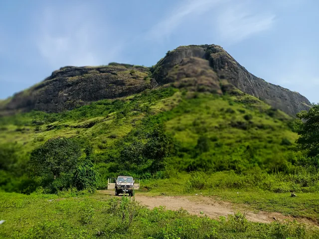
Situated at a height of 3000ft from sea level, the fort houses many a remnant of constructions that take us about 800 years back into the time. The fort is in Pune district, at a distance of 20 km from the city of Junnar. The region at the foothills of the fort contains exotic flora & fauna. It was here that we could spot at least 12 varieties of birds. Village of Chavandwadi lies at the base of the fort. History :      Medieval period Malik Ahmed founded the Nizam Dynasty in 1485. He was the first Nizamshah who acquired the fort of Chavand after the dissolution of the Bahmani Empire.

The seventh Nizamshah was Second Burhanshah. His grandson Bahadurshah was imprisoned here in 1594. Bahadurshah was the nephew of Chandbibi, a renowned personality from the same period. She played an important role in helping him to achieve the throne. In 1636 Shahajiraje, father of Shivaji Maharaj, signed a treaty with the Moghals, in which the Moghals got Chavand.

Shivaji Maharaj named the fort as “Prasannagad”.

Mythological references

  1. The forts named after the names of great sages (for e.g. Vasota, named after Vasistha) are pre-ancient forts.
  2. The forts decorated by Buddhist carvings and sculptures (for e.g. Shivneri) are ancient forts.
  3. Forts belonging to the medieval period are related to Shaiva, Shakta or Naath.
  4. The goddess Chamunda is an idol of destruction of evil, with a terrifying appearance, armed with weapons. The deity belongs to Bengal, Bihar and Karnataka.

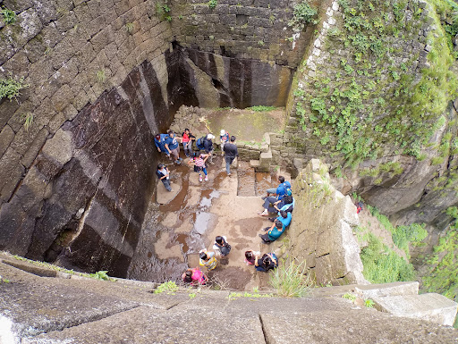
Saptamatrika (The seven cisterns) :      The British in their attack have destroyed many a construction in the eighteenth century. Here a temple half buried in the earth can be seen. As we go ahead on the left, we can see 7 water tanks aligned along each other. These have much mythological significance, & their names are as follows: Brahmi, Maheshwari, Kaumari, Vaishnavi, Varahi, Indrayani & Chamunda, the most powerful goddess of all.2. Human made caves :      As we proceed towards the northern direction around the fortification, we can see that a proper way was constructed hereby to move around to keep watch. On the north side of the fort, human made caves are situated where the fortification ends. Here it is said that a secret passage exists, amidst the wall, right below the caves. As we go the south side, we can have a beautiful view of the river Kukdi that originates from Kukdeshwar, a famous pilgrimage near the fort. On the southeastern side, no fortification exists as steep fall dominates this place. Again as we proceed westwards, we can see the fortification here. This fort being strongly secured was used for imprisoning Bahadurshah Nizam in 1594.3. Temple of goddess Chamunda :      On the topmost part of the fort, i.e. on a small hillock, is situated the temple of Goddess Chamunda. Here rises the question, that who brought this deity here in Maharashtra, which is predominantly from the provinces of Bengal, Bihar & Mysore. The answer is also quite simple. Naneghat had been the main route for transport of goods that came from other provinces via harbour of Sopara & Kalyan, the place of junction. Some well established businessman from Mysore, who came through Naneghat, must have established Chamunda here. Folks were unable to utter Chamunda, & they called it as Chavand, hence was named the fort.

The places in the region of Naneghat reflect the rich culture of Satvaahan dynasty, and the well-developed artistic works that existed during this era. The temple of “Kukdeshwar” must be visited when we go to Chavand. The simplicity of this place is worth experiencing. The caves of Shivneri and “Lenyadri”, another famous pilgrimage, are worth visiting. From the top of the fort, we can have a glimpse of the mountain of Shambhu & the fort of Jeevdhan on the west, Hadsar on the north, Shivneri on the east & the route of Naneghat along the fort. The topmost part of Shivneri is clearly visible from here. Along with a rich geographical position, the fort also has a rich history, which can be stated in...

   Read more
avatar
5.0
6y

I visited Chawand fort in September. This is the pleasant time of the year with slight rain, mild climate and plenty of greenery everywhere. It was drizzling sporadically in cloudy weather with cool air.

Chawand is a small fort. It is approximately 16 km away from Junnar. The road had some bad patches. This fort is very well maintained by the villagers around. Just before the base village, a small road branches off to the right. Here you are welcomed by an arch gate with fort name on it. Though the name Chawand (चावंड) is more popular, it is also known by few other names like PrasannaGad (प्रसन्नगड), ChamundGad (चामुंडगड), Chawandas (चावंडस), Chaund (चाऊंड), Chand (चाँद) etc. On this road, there is a paid parking area. This road further branches to the right as a gravel road. It takes you to the steps for Chawand.

The moment you see this fort, you would be awestruck. Because, this entire fort is a huge single basalt rock with steep 90° sides. Other than the steps, there is no way to climb this fort from any direction.

The entire climb is with steps. Upto 70% of the path, the steps are newly built and are in excellent condition. The last patch has old steps. Some of these steps are carved in stone and are risky. However there is a very good railing and a safety wire to hold. So it is not difficult at all. The remaining old steps in last patch are too big (almost one and half feet in height) and too steep as well. Once you climb all the steps, you can see the main entrance of the fort. This is the one and only entrance for this fort. A regular trekker should take 30 minutes to reach to the top. For others, with rest breaks it might take 1-1:30 hours at the most.

When you enter the fort top, there are two ways. One goes straight, and the other to the right with few more steps carved in stone. The straight way takes you to the largest water tank on fort, named SaptMatruka (सप्तमातृका). The good thing is that, there are name plates and direction boards at every important point. The way to right takes you to the ancient fort office (सदर) and then to Chawanda Devi (चावंडादेवी) temple. Except the main entrance, the temple and few water tanks, all other structures are heavily damaged. Way to Chawanda Devi temple is slippery. The temple is situated at the top of a small hill on the fort. It is the highest peak of this fort. The temple is so small that 2-3 people will make it crowded. But from this place you can have a look around the entire fort and the surrounding area. On the east you can see the wall of Manikdoh (माणिकडोह) dam. On north-east are some mountains and ranges of Sahyadri. The two adjacent small mountains in the middle are HanumantGad (हनुमंतगड) & Nimgiri Fort (निमगिरी किल्ला). Exactly between Nimgiri and the dam wall is Hadsar Fort (हडसर किल्ला). Far on the north-west you can see power transmission towers, that are near NaneGhat (नाणेघाट). Jivdhan Fort (जीवधन किल्ला) won't be visible from here due to another mountain in between.

After seeing temple, you can descend the hill and follow the path that traverses hill base. Some of this path is a paved walkway. There are many water tanks on this path. Following this walkway you can see the entire fort. It hardly takes 20-30 minutes. Some patches have tall bushes. Some of the non-paved patch is very slippery.

If you visit during this season (August-October), you can see the fort covered with beautiful yellow & purple flowers. Water is abundant on this fort. But there is no shelter. For camping, water purification tablets and tent is must. With several insects and reptiles, sleeping in open space is to be avoided strictly. Mobile network is available almost everywhere on the fort, except while climbing the fort.

Climbing Time: 30 minutes Difficulty Level: Easy Endurance...

   Read more
avatar
5.0
2y

Prasannagad, located near Pune, is a hidden gem that becomes even more enchanting during the monsoon season. Nestled amidst the lush Sahyadri mountain range, this fort offers a perfect getaway for nature lovers and adventure enthusiasts. The accessibility of Prasannagad makes it an ideal destination for a thrilling two-wheeler ride.

As you embark on your journey to Prasannagad, the picturesque landscape will leave you spellbound. Riding through the winding roads, surrounded by green valleys and cascading waterfalls, adds an element of excitement to the trip. The monsoon showers paint the surroundings in vibrant hues, breathing life into every leaf and flower along the way.

Upon reaching Prasannagad, the ancient fort stands majestically atop a hill, offering panoramic views of the surrounding valleys. The fort, although in ruins, exudes a mystical charm that transports you back in time. Exploring the fort's remnants, you can envision its glorious past and the stories it holds within its weathered walls.

The trek to the fort is relatively easy, making it accessible for both novice and experienced trekkers. The monsoon season adds an extra thrill to the climb, with the fragrance of wet soil and the sound of raindrops creating a serene atmosphere. The cool breeze and misty atmosphere only enhance the sense of adventure.

As you ascend, you'll come across diverse flora and fauna, adding to the natural beauty of the place. The sight of wildflowers blooming along the trail and the songs of birds create a harmonious symphony of nature. Reaching the summit rewards you with breathtaking views of the sprawling valleys below, shrouded in mist and cloud cover.

Camping atop Prasannagad is a delightful experience, especially during the monsoon. Setting up tents amidst the clouds and waking up to the sound of rainfall is a rejuvenating escapade for the soul. The tranquility and solitude of the surroundings provide an opportunity to disconnect from the chaos of daily life and reconnect with nature.

In conclusion, Prasannagad near Pune is a captivating destination to visit during the monsoon. The scenic beauty, historical significance, and the sense of adventure make it a memorable experience. Riding on a two-wheeler adds an element of thrill to the journey, allowing you to immerse yourself fully in the beauty of the Sahyadri mountains. So gear up, embrace the monsoon magic, and embark on an unforgettable expedition to...

   Read more
Page 1 of 7
Previous
Next

Posts

Niranjan MKNiranjan MK
I visited Chawand fort in September. This is the pleasant time of the year with slight rain, mild climate and plenty of greenery everywhere. It was drizzling sporadically in cloudy weather with cool air. Chawand is a small fort. It is approximately 16 km away from Junnar. The road had some bad patches. This fort is very well maintained by the villagers around. Just before the base village, a small road branches off to the right. Here you are welcomed by an arch gate with fort name on it. Though the name Chawand (चावंड) is more popular, it is also known by few other names like PrasannaGad (प्रसन्नगड), ChamundGad (चामुंडगड), Chawandas (चावंडस), Chaund (चाऊंड), Chand (चाँद) etc. On this road, there is a paid parking area. This road further branches to the right as a gravel road. It takes you to the steps for Chawand. The moment you see this fort, you would be awestruck. Because, this entire fort is a huge single basalt rock with steep 90° sides. Other than the steps, there is no way to climb this fort from any direction. The entire climb is with steps. Upto 70% of the path, the steps are newly built and are in excellent condition. The last patch has old steps. Some of these steps are carved in stone and are risky. However there is a very good railing and a safety wire to hold. So it is not difficult at all. The remaining old steps in last patch are too big (almost one and half feet in height) and too steep as well. Once you climb all the steps, you can see the main entrance of the fort. This is the one and only entrance for this fort. A regular trekker should take 30 minutes to reach to the top. For others, with rest breaks it might take 1-1:30 hours at the most. When you enter the fort top, there are two ways. One goes straight, and the other to the right with few more steps carved in stone. The straight way takes you to the largest water tank on fort, named SaptMatruka (सप्तमातृका). The good thing is that, there are name plates and direction boards at every important point. The way to right takes you to the ancient fort office (सदर) and then to Chawanda Devi (चावंडादेवी) temple. Except the main entrance, the temple and few water tanks, all other structures are heavily damaged. Way to Chawanda Devi temple is slippery. The temple is situated at the top of a small hill on the fort. It is the highest peak of this fort. The temple is so small that 2-3 people will make it crowded. But from this place you can have a look around the entire fort and the surrounding area. On the east you can see the wall of Manikdoh (माणिकडोह) dam. On north-east are some mountains and ranges of Sahyadri. The two adjacent small mountains in the middle are HanumantGad (हनुमंतगड) & Nimgiri Fort (निमगिरी किल्ला). Exactly between Nimgiri and the dam wall is Hadsar Fort (हडसर किल्ला). Far on the north-west you can see power transmission towers, that are near NaneGhat (नाणेघाट). Jivdhan Fort (जीवधन किल्ला) won't be visible from here due to another mountain in between. After seeing temple, you can descend the hill and follow the path that traverses hill base. Some of this path is a paved walkway. There are many water tanks on this path. Following this walkway you can see the entire fort. It hardly takes 20-30 minutes. Some patches have tall bushes. Some of the non-paved patch is very slippery. If you visit during this season (August-October), you can see the fort covered with beautiful yellow & purple flowers. Water is abundant on this fort. But there is no shelter. For camping, water purification tablets and tent is must. With several insects and reptiles, sleeping in open space is to be avoided strictly. Mobile network is available almost everywhere on the fort, except while climbing the fort. Climbing Time: 30 minutes Difficulty Level: Easy Endurance Level: Medium
Vikram PataskarVikram Pataskar
Chavand Fort: The Sahyadri mountain range is more than just a natural wonder; it is a repository of rich history, showcasing the legacy of the great Marathas and the ancient Satavahanas. These rulers left behind remarkable art and architecture, with few modern carvings that can compare. The Satavahanas once ruled over what is now Maharashtra, and their reign is still remembered through the forts and caves they built in the heart of the Sahyadris. Among these, the forts of Jeevdhan, Hadsar, Mahishgad, and Chavand, which date back to the Satavahana era, stand as testaments to their rule. Chavand Fort, in particular, holds significant historical value. Perched 3,000 feet above sea level, Chavand Fort contains the remnants of structures that transport us back around 800 years. Located in Pune district, about 20 kilometers from the town of Junnar, the fort is surrounded by lush flora and fauna. The area at the base of the fort is home to at least 12 different bird species, adding to its natural beauty. The village of Chavandwadi lies at the fort's foothills. How to Reach: To reach the top of the fort, follow the path that runs alongside the village school on the western side. The trek to the entrance gate takes about 45 minutes. From there, stone steps lead to the plateau where the remnants of ancient constructions can be explored. Accommodation: Trekkers also often stay in the village school. Alternatively, there is a boarding facility at the nearby Kukdeshwar temple. Food Facility: Available in the base village. Drinking Water: The fort has several cisterns and tanks, with the two on the southwest side being the most reliable. Type: Hill fort. Fort Range: Naneghat. District: Pune. Difficulty Grade: Medium. Time to Reach: Approximately 45 minutes. (Vikram Pataskar)
Mohan DoiphodeMohan Doiphode
गडावरील ठिकाणे दरवाजातून आत जाताच दहा पायऱ्या चढून गेल्यावर दोन वाटा लागतात. वरची उजवीकडची वाट उद्ध्वस्त अवशेषांकडे घेऊन जाते, तर डावीकडे तटबंदीच्या बाजूने जाणारी वाट आहे. उजव्या बाजूस कातळात कोरलेल्या १५-२० पायऱ्या चढून गेल्यावर काही वास्तू नजरेत येतात. एका वास्तूचा चौथरा अजून व्यवस्थित आहे. इथे आपल्याला अशा बऱ्याच वास्तू दिसतात म्हणून असा निष्कर्ष काढता येईल की इथेच सारा कारभार चालत असावा. जवळ जवळ १५ ते २० वास्तू इथे आहेत. जेथे चौथरा शिल्लक आहे तेथेच मोठे गोल उखळ आहे. मात्र त्यास खालच्या बाजूला एक छिद्र आहे. बाजूलाच २ संलग्र अशी टाकी आहेत येथून उत्तरेस थोडे पुढे गेलो की एक खचत चाललेली वास्तू नजरेस पडते. हिच्या बांधकामावरून असे प्रतीत होते की हे एक मंदिर असावे. पण बरीच खचल्यामुळे जास्त काही अंदाज बांधता येत नाही. येथून आजूलाबाजूला साधारण ३०० मी. च्या परिसरात १०-१५ उद्ध्वस्त बांधकामे तशीच ७-८ टाकी आढळून येतात. गडाच्या वायव्य भागात आपल्याला एकमेकांना लागून अशी सात टाकी आहेत. ही टाकी सप्त मातृकांशी निगडित आहेत. गडाच्या याच भागात बऱ्यापैकी तटबंदी असून आग्रेय भाग कडांनी व्यापला आहे. यावरून कळून येतं की गड किती दुर्गम आहे. म्हणूनच बहादूरशाह निजामाला येथे ठेवण्यात आले होते. ज्या भागात तटबंदी आहे त्या भागात या तटबंदीच्या बाजूने फिरण्यास जागा आहे. ही बहुदा गस्त घालण्यासाठी असावी. या ठिकाणी बराच उतार असून काही ठिकाणी हौद आहेत. थोडे पुढे उजवीकडे गेल्यावर एका मंदिराचे अवशेष आढळतात. येथेही बरेच शिल्पकाम आढळते. ज्या ठिकाणी तटबंदी ढासळलेली आहे, तिथे चिर्याचे दगड गाडग्यासारखे रचून ठेवले आहेत. हे कोणाचे काम असावे हे कळत नाही. ईशान्य भागात ज्या ठिकाणी तटबंदी संपते त्या ठिकाणी कातळकोरीव गुहा आहेत. या पहारेकर्यांच्या चौक्या असाव्यात. एक गुहा अगदी सुस्थितीत आहे. गुहेत प्रवेश केल्यावर दोन्ही बाजूला हौदसदृश साधारण ५ फूट खोलीचे बांधकाम आढळते. या गुहेलगत असलेल्या तटबंदीच्या खाली भुयारी मार्गाचे प्रवेशद्वार आहे असे ग्रामस्त सांगतात. येथे रॅपलिंग करून जाता येते.यापुढे आपण गडाच्या पूर्वेस येतो. या भागात कोणतेही अवशेष नाहीत. बेलाग कडांनी हा भाग व्यापला असल्यामुळे इथे तटबंदी नाही. हा भाग बराच विस्तीर्ण असूनही निर्जन आणि ओसाड आहे. जवळ जवळ अर्ध्या कि.मी.च्या परिसरात एकही बांधकाम आढळत नाही. गडाच्या दक्षिण बाजूला आणि नैऋत्येस आपल्याला तुरळक अशी तटबंदी आढळते. इथेच पाण्याची दोन टाकी आहेत. इथून पुन्हा पश्चिमेकडे निघाल्यावर आपल्याला मजबूत अशा तटबंदीचे दर्शन घडते. दोन बुरूजही आढळतात. इथून आपण टेकडी कडे निघतो, मंदिर पाहायला.गडाच्या सर्वात उंच भागात चामुंडा देवीचे मंदिर आहे. मंदिरातील मूर्ती प्राचीन असून बांधकाम मात्र नवीन आहे. आजुबाजूला जुन्या मंदिराचे अवशेष विखुरलेले दिसतात. एक तुटलेली मूर्ती आढळते जी एखाा ऋषीचे प्रतीक असावी. तसेच एक आश्चर्यकारक गोष्ट म्हणजे या चामुंडा देवीच्या मंदिरासमोर आढळणारा नंदी. जुन्या अवशेषांमध्येही नंदीची मूर्ती आढळते. याचा अर्थ हा होतो की जवळच कुठेतरी शिवलिंग असावे आणि काळाच्या ओघात हरवले असावे.
See more posts
See more posts
hotel
Find your stay

Pet-friendly Hotels in Maharashtra

Find a cozy hotel nearby and make it a full experience.

I visited Chawand fort in September. This is the pleasant time of the year with slight rain, mild climate and plenty of greenery everywhere. It was drizzling sporadically in cloudy weather with cool air. Chawand is a small fort. It is approximately 16 km away from Junnar. The road had some bad patches. This fort is very well maintained by the villagers around. Just before the base village, a small road branches off to the right. Here you are welcomed by an arch gate with fort name on it. Though the name Chawand (चावंड) is more popular, it is also known by few other names like PrasannaGad (प्रसन्नगड), ChamundGad (चामुंडगड), Chawandas (चावंडस), Chaund (चाऊंड), Chand (चाँद) etc. On this road, there is a paid parking area. This road further branches to the right as a gravel road. It takes you to the steps for Chawand. The moment you see this fort, you would be awestruck. Because, this entire fort is a huge single basalt rock with steep 90° sides. Other than the steps, there is no way to climb this fort from any direction. The entire climb is with steps. Upto 70% of the path, the steps are newly built and are in excellent condition. The last patch has old steps. Some of these steps are carved in stone and are risky. However there is a very good railing and a safety wire to hold. So it is not difficult at all. The remaining old steps in last patch are too big (almost one and half feet in height) and too steep as well. Once you climb all the steps, you can see the main entrance of the fort. This is the one and only entrance for this fort. A regular trekker should take 30 minutes to reach to the top. For others, with rest breaks it might take 1-1:30 hours at the most. When you enter the fort top, there are two ways. One goes straight, and the other to the right with few more steps carved in stone. The straight way takes you to the largest water tank on fort, named SaptMatruka (सप्तमातृका). The good thing is that, there are name plates and direction boards at every important point. The way to right takes you to the ancient fort office (सदर) and then to Chawanda Devi (चावंडादेवी) temple. Except the main entrance, the temple and few water tanks, all other structures are heavily damaged. Way to Chawanda Devi temple is slippery. The temple is situated at the top of a small hill on the fort. It is the highest peak of this fort. The temple is so small that 2-3 people will make it crowded. But from this place you can have a look around the entire fort and the surrounding area. On the east you can see the wall of Manikdoh (माणिकडोह) dam. On north-east are some mountains and ranges of Sahyadri. The two adjacent small mountains in the middle are HanumantGad (हनुमंतगड) & Nimgiri Fort (निमगिरी किल्ला). Exactly between Nimgiri and the dam wall is Hadsar Fort (हडसर किल्ला). Far on the north-west you can see power transmission towers, that are near NaneGhat (नाणेघाट). Jivdhan Fort (जीवधन किल्ला) won't be visible from here due to another mountain in between. After seeing temple, you can descend the hill and follow the path that traverses hill base. Some of this path is a paved walkway. There are many water tanks on this path. Following this walkway you can see the entire fort. It hardly takes 20-30 minutes. Some patches have tall bushes. Some of the non-paved patch is very slippery. If you visit during this season (August-October), you can see the fort covered with beautiful yellow & purple flowers. Water is abundant on this fort. But there is no shelter. For camping, water purification tablets and tent is must. With several insects and reptiles, sleeping in open space is to be avoided strictly. Mobile network is available almost everywhere on the fort, except while climbing the fort. Climbing Time: 30 minutes Difficulty Level: Easy Endurance Level: Medium
Niranjan MK

Niranjan MK

hotel
Find your stay

Affordable Hotels in Maharashtra

Find a cozy hotel nearby and make it a full experience.

Get the Appoverlay
Get the AppOne tap to find yournext favorite spots!
Chavand Fort: The Sahyadri mountain range is more than just a natural wonder; it is a repository of rich history, showcasing the legacy of the great Marathas and the ancient Satavahanas. These rulers left behind remarkable art and architecture, with few modern carvings that can compare. The Satavahanas once ruled over what is now Maharashtra, and their reign is still remembered through the forts and caves they built in the heart of the Sahyadris. Among these, the forts of Jeevdhan, Hadsar, Mahishgad, and Chavand, which date back to the Satavahana era, stand as testaments to their rule. Chavand Fort, in particular, holds significant historical value. Perched 3,000 feet above sea level, Chavand Fort contains the remnants of structures that transport us back around 800 years. Located in Pune district, about 20 kilometers from the town of Junnar, the fort is surrounded by lush flora and fauna. The area at the base of the fort is home to at least 12 different bird species, adding to its natural beauty. The village of Chavandwadi lies at the fort's foothills. How to Reach: To reach the top of the fort, follow the path that runs alongside the village school on the western side. The trek to the entrance gate takes about 45 minutes. From there, stone steps lead to the plateau where the remnants of ancient constructions can be explored. Accommodation: Trekkers also often stay in the village school. Alternatively, there is a boarding facility at the nearby Kukdeshwar temple. Food Facility: Available in the base village. Drinking Water: The fort has several cisterns and tanks, with the two on the southwest side being the most reliable. Type: Hill fort. Fort Range: Naneghat. District: Pune. Difficulty Grade: Medium. Time to Reach: Approximately 45 minutes. (Vikram Pataskar)
Vikram Pataskar

Vikram Pataskar

hotel
Find your stay

The Coolest Hotels You Haven't Heard Of (Yet)

Find a cozy hotel nearby and make it a full experience.

hotel
Find your stay

Trending Stays Worth the Hype in Maharashtra

Find a cozy hotel nearby and make it a full experience.

गडावरील ठिकाणे दरवाजातून आत जाताच दहा पायऱ्या चढून गेल्यावर दोन वाटा लागतात. वरची उजवीकडची वाट उद्ध्वस्त अवशेषांकडे घेऊन जाते, तर डावीकडे तटबंदीच्या बाजूने जाणारी वाट आहे. उजव्या बाजूस कातळात कोरलेल्या १५-२० पायऱ्या चढून गेल्यावर काही वास्तू नजरेत येतात. एका वास्तूचा चौथरा अजून व्यवस्थित आहे. इथे आपल्याला अशा बऱ्याच वास्तू दिसतात म्हणून असा निष्कर्ष काढता येईल की इथेच सारा कारभार चालत असावा. जवळ जवळ १५ ते २० वास्तू इथे आहेत. जेथे चौथरा शिल्लक आहे तेथेच मोठे गोल उखळ आहे. मात्र त्यास खालच्या बाजूला एक छिद्र आहे. बाजूलाच २ संलग्र अशी टाकी आहेत येथून उत्तरेस थोडे पुढे गेलो की एक खचत चाललेली वास्तू नजरेस पडते. हिच्या बांधकामावरून असे प्रतीत होते की हे एक मंदिर असावे. पण बरीच खचल्यामुळे जास्त काही अंदाज बांधता येत नाही. येथून आजूलाबाजूला साधारण ३०० मी. च्या परिसरात १०-१५ उद्ध्वस्त बांधकामे तशीच ७-८ टाकी आढळून येतात. गडाच्या वायव्य भागात आपल्याला एकमेकांना लागून अशी सात टाकी आहेत. ही टाकी सप्त मातृकांशी निगडित आहेत. गडाच्या याच भागात बऱ्यापैकी तटबंदी असून आग्रेय भाग कडांनी व्यापला आहे. यावरून कळून येतं की गड किती दुर्गम आहे. म्हणूनच बहादूरशाह निजामाला येथे ठेवण्यात आले होते. ज्या भागात तटबंदी आहे त्या भागात या तटबंदीच्या बाजूने फिरण्यास जागा आहे. ही बहुदा गस्त घालण्यासाठी असावी. या ठिकाणी बराच उतार असून काही ठिकाणी हौद आहेत. थोडे पुढे उजवीकडे गेल्यावर एका मंदिराचे अवशेष आढळतात. येथेही बरेच शिल्पकाम आढळते. ज्या ठिकाणी तटबंदी ढासळलेली आहे, तिथे चिर्याचे दगड गाडग्यासारखे रचून ठेवले आहेत. हे कोणाचे काम असावे हे कळत नाही. ईशान्य भागात ज्या ठिकाणी तटबंदी संपते त्या ठिकाणी कातळकोरीव गुहा आहेत. या पहारेकर्यांच्या चौक्या असाव्यात. एक गुहा अगदी सुस्थितीत आहे. गुहेत प्रवेश केल्यावर दोन्ही बाजूला हौदसदृश साधारण ५ फूट खोलीचे बांधकाम आढळते. या गुहेलगत असलेल्या तटबंदीच्या खाली भुयारी मार्गाचे प्रवेशद्वार आहे असे ग्रामस्त सांगतात. येथे रॅपलिंग करून जाता येते.यापुढे आपण गडाच्या पूर्वेस येतो. या भागात कोणतेही अवशेष नाहीत. बेलाग कडांनी हा भाग व्यापला असल्यामुळे इथे तटबंदी नाही. हा भाग बराच विस्तीर्ण असूनही निर्जन आणि ओसाड आहे. जवळ जवळ अर्ध्या कि.मी.च्या परिसरात एकही बांधकाम आढळत नाही. गडाच्या दक्षिण बाजूला आणि नैऋत्येस आपल्याला तुरळक अशी तटबंदी आढळते. इथेच पाण्याची दोन टाकी आहेत. इथून पुन्हा पश्चिमेकडे निघाल्यावर आपल्याला मजबूत अशा तटबंदीचे दर्शन घडते. दोन बुरूजही आढळतात. इथून आपण टेकडी कडे निघतो, मंदिर पाहायला.गडाच्या सर्वात उंच भागात चामुंडा देवीचे मंदिर आहे. मंदिरातील मूर्ती प्राचीन असून बांधकाम मात्र नवीन आहे. आजुबाजूला जुन्या मंदिराचे अवशेष विखुरलेले दिसतात. एक तुटलेली मूर्ती आढळते जी एखाा ऋषीचे प्रतीक असावी. तसेच एक आश्चर्यकारक गोष्ट म्हणजे या चामुंडा देवीच्या मंदिरासमोर आढळणारा नंदी. जुन्या अवशेषांमध्येही नंदीची मूर्ती आढळते. याचा अर्थ हा होतो की जवळच कुठेतरी शिवलिंग असावे आणि काळाच्या ओघात हरवले असावे.
Mohan Doiphode

Mohan Doiphode

See more posts
See more posts