Singalila National Park is a national park of India located on the Singalila Ridge at an altitude of more than 7000 feet above sea level, in the Darjeeling district of West Bengal. It is well known for the trekking route to Sandakphu that runs through it.The park was declared a wildlife sanctuary in 1986, and was made an Indian national park in 1992. The region had long been used as the trekking route from Manebhanjang to Sandakphu (the highest peak of West Bengal) and Phalut.The park is located in the Darjeeling subdivision, Darjeeling district, West Bengal, India. It is bordered on the north by the state of Sikkim and on the west by the country of Nepal.The park is part of the Eastern Himalayas. The Singalila Ridge, which runs roughly North to South and separates Himalayan West Bengal from the other Eastern Himalayan ranges to the west of it. The two highest peaks of West Bengal, Sandakphu (3630 m) and Phalut (3600 m), are located on the ridge and inside the park. River Rammam and River Sirikhola flow through the park.The park has no significant history of human settlement. However, small settlements have grown up along the trekking route to Sandakphu and Phalut. There is a reasonably large village at Kala Pokhri, around the lake of the same name. The Singalila Ridge was used as an approach route by the first documented mountaineering team which unsuccessfully attempted to climb Kanchenjunga in 1905. The team was led by Jules Jacot-Guillarmod and the famous occultist Aleister Crowley.The national park falls in the Indomalaya ecozone, and the biomes corresponding to the ecozone which are present in the park are:
Eastern Himalayan subalpine conifer forests of the Temperate coniferous forests biome Eastern Himalayan broadleaf forests of the Temperate broadleaf and mixed forests biome Himalayan subtropical pine forests of the Subtropical coniferous forest biome The subtropical biome roughly exists in the altitude range of 1800 to 3000 m, and the temperate biome exists in the altitude range of 3000 m to 4500 m.Thick bamboo, oak, magnolia and rhododendron forest between 2000 and 3600 m cover the Singalila Ridge. There are two seasons of wildflower bloom - one in spring (March and April) when the rhododendrons bloom, and another in the post-monsoon season (around October), when the lower forests bloom (Primula, Geranium, Saxifraga, Bistort, Senecio, Cotoneaster and numerous orchids). Sandakphu is known as the "mountain of poisonous plants" due to the large concentration of Himalayan cobra lilies (Arisaema) which grow there.The major issues at the park are trash collection on trekking routes and ensuring minimal damage of flora by trekkers, as flora at such high altitudes tend to grow really slowly. Grazing of yak and cattle from neighbouring villages can also be a problem. Forest fires can be a threat to the park, especially in spring when the accumulated debris from winter can be a hazard. A forest fire swept through the park on 6 March 2006.
Even though the national park has a resident red panda population of only about 20-25 members, Project Red Panda (funded by the Central Zoo Authority) chose Singalila National Park for reintroduction of red pandas from its captive breeding program at the Padmaja Naidu Himalayan Zoological Park in Darjeeling, mainly due to reasons of proximity. Two females, Sweety and Milli, were released in November 2004. Milli was killed by a leopard, but Sweety adapted to the wild and gave birth to an offspring - the first such successful re-entry for red panda. [1]
The reintroduction was filmed by noted Indian filmmakers Rajesh Bedi and Naresh Bedi. The documentary, named Cherub of the Mist, won the Best Conservation and Environmental Film at the 29th International Wildlife Film...
Read moreSingalila National Park is a protected area located on the Singalila Ridge in the Darjeeling district of West Bengal, India. Here are key points about Singalila National Park:
Location: Singalila National Park is situated along the India-Nepal border, covering parts of the Darjeeling district in West Bengal.
Singalila Ridge: The park is named after the Singalila Ridge, which is a prominent ridge of the Eastern Himalayas. The ridge forms the natural boundary between India and Nepal.
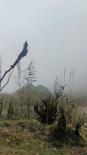
Biodiversity: Known for its diverse flora and fauna, Singalila National Park is home to a variety of wildlife, including red pandas, Himalayan black bears, barking deer, and numerous bird species.
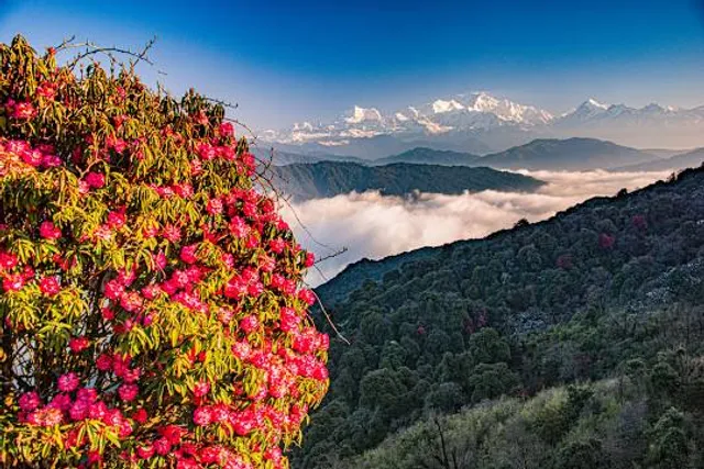
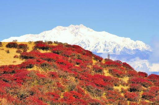
Rhododendron Forests: The park is famous for its vibrant rhododendron forests. During the blooming season, usually in spring, the park transforms into a colourful landscape.
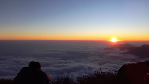
Trekking: Singalila National Park is a popular destination for trekking enthusiasts. The Singalila Trek is a well-known trek that offers panoramic views of the Himalayan peaks, including Mount Everest.
Sandakphu: Sandakphu, the highest peak in West Bengal, is located within the Singalila National Park. The trek to Sandakphu is a major attraction for adventure seekers.
Panoramic Views: The park provides breathtaking panoramic views of several Himalayan peaks, including Mount Everest, Lhotse, Makalu, and Kanchenjunga.
Phalut: Phalut, another prominent peak in the region, is accessible via trekking from Sandakphu. It offers stunning views of the surrounding mountains.
Flora: The park is home to diverse vegetation, including oak forests, magnolia, and a variety of alpine flora.
Avifauna: Singalila National Park is a paradise for birdwatchers, with a rich diversity of bird species. It is home to numerous pheasants, eagles, and other Himalayan birds.
Accessibility: The entry point to Singalila National Park is often from Mane Bhanjyang or Dhotrey. The park can be reached from Darjeeling or Siliguri.
Best Time to Visit: The best time to visit Singalila National Park is during the spring and autumn months when the weather is favourable for trekking, and the views are clear.
Permits: Permits are required to enter Singalila National Park, and visitors are advised to check with the local forest department for regulations and permissions.
Singalila National Park is not only a haven for nature lovers and trekkers but also offers an opportunity to witness the grandeur of the Himalayan landscape. As regulations and conditions may change, it's advisable to check with the local authorities for the latest information before...
Read more#Extraordinary
Sandakphu is the highest point in the West Bengal. It is at the Indo-Nepal border. It is within the Singalila National Park. The golden point of Sandakphu is the magnificent 180 degree view of snow capped mountain. From left to right you can see - Lhotse, Mt Everest, Makalu, three sisters, Kumbhakarna, Kanchanjunga, north Kabru, south kabru, black kabru, Sabru, Kabru dome and Pandim. Other ranges of Bhutan and Arunachal Pradesh are also visible depending on the weather condition.
It is a basic level trekking as well as family tour. Starting point - Manebhanjang in Darjeeing dist. (26 km from Darjeeling). We started from Dhotre. Dhotre - 8500 Feets. Tumling - 2895 Mts. Gairibas - 2625 Mts. Kalipokhri - 3185 Mts. Sandakphu - 3636 mts. From Sandakphu we came back via Gurdum and Rimbik. Gurdum - 1900 Mts. Rimbik - 1700 Mts. We covered the entire distance in 4 night 5 days. Our itinerary was as follows - 1st day - Dhotre to Tumling - 6 km. Night stay at Sikhar Lodge. 2nd day - Tumling to Kalipokhri via Singalila National Park check post, Gairibas, Kaiyakatta. - (Tumling to Gairibas - 7 km. Gairibas to Kaiyakatta - 2 km. Kaiykatta to Kalipokhri - 5 km.) Night stay at Pandim Lodge. 3rd day - Kalipokhri to Sandakphu via Bikhaybhanj (Kalipokhri to Bikhaybhanj - 2 km. Bikhaybhanj to Sandakphu - 4 km). Night stay at Sunrise Hotel. We didn't go to Phalut - which is another 21 km. 4th day - Sandakphu to Gurdum 12 km. Night stay at Himalayan Sherpa Lodge. 5th day - Gurdum to Rimbik via Srikhola, Sepi ( Gurdum to Srikhola - 5 km, Srikhola to Sepi - 1 km, Sepi to Rimbik - 6 km.) Our trekking Concluded at Rimbik. From Rimbik we took shared jeep (150 per head) to reach Sukhiapokhri. It took 3.5 hours. We reserved a car to reach Siliguri via Mirik. It took 3 hours. It was end March. Climate - Temperature was between 15 to -5 degree (approx.). Partly cloudy, partly sunny. Rain and thundershower on night 2. Hail storm followed by snow fall on night 3. Following morning weather was clear and we got excellent view of snow peaks. Rhododendrons and Magnolias have just started blooming. We could see varieties of birds. Guide is a must in Sandakphu- Phalut trekking now a days. Guides are available from Manebhanjang as well as Dhotre. The entire route of Sandakphu- Phalut is now motorable. Land Rovers are available from Manebhanjang.
Enjoy The beauty of...
Read more