
Kurseong (Bengali pronunciation: [ˈkaɾʃi̯aŋ], Nepali pronunciation: [ˈkʰʌrsaŋ]) is a town and a municipality in Darjeeling district in the Indian state of West Bengal. It is the headquarters of the Kurseong subdivision. Located at an altitude of 1,482.55 metres (4,864.0 ft), Kurseong is 32 kilometres (20 mi) from Darjeeling and has a pleasant climate throughout the year.
Kurseong is 34 kilometres (21 mi) from Siliguri and is connected to the city by road and the Darjeeling Himalayan Railway. The nearest airport is at Bagdogra and the nearest major railway station is New Jalpaiguri, which is about 45 kilometres (28 mi) from the town. The economy is based primarily on education and tourism. The origin of the name is unclear; stories suggest it comes from the Lepcha language word for "small orchid", kurson-rip because of the little white orchids (Coelogyne cristata) dotting the valleys, or perhaps the term for a stick made out of a local cane.(O'Malley 1999, p. 216) The original inhabitants were the Lepcha people, who named their home "Kurseong", because every spring it was alive and bright with Kurson-Rip orchids. In the remote past, Kurseong was a part of the Kingdom of Sikkim, even before the British came to India. However, in around 1780 the Kingdom of Nepal conquered and annexed Kurseong and its surrounding areas. Then came the Gurkha War, which the Nepalese lost. The 1817 Treaty of Titalia restored Kurseong to Sikkim.[7]
With its mountains providing a cool and dry environment in the summer, Kurseong was a favourite of the British. Nevertheless, they found travelling there from the plains of Bengal difficult, even on warm sunny days because of the mountains. Although a road was built from Kurseong to Darjeeling from Titalia in the 1770s and 1780s, its irregular maintenance soon made the new route, the Military Road, almost useless. The next route, Hill Cart Road (now Tenzing Norgay Road), opened in 1861 and fared better.
Nevertheless, in 1835 the British decided that Darjeeling would make an excellent sanitorium and summer residence for their military and civilian officers along with their families. Negotiations with the Chogyal of Sikkim, Tshudpud Namgyal, provided them a strip of hill territory in Kurseong for an annual fee. As one of the hill stations on the road to Darjeeling, Kurseong began to develop.
Kurseong is home to one of the oldest municipalities in the state of West Bengal. Established as an independent Municipality in 1879, it did not become a Sub-Division until 1890, when the District of Darjeeling was formed. Kurseong and the District were added to the Rajshahi Division (now West Central Bangladesh) by the British Raj for the Bengal Presidency. In 1908, they were transferred to the Bhagalpur Division in the same Presidency.
Before Independence from the British, there were 12 ward commissioners. Four of them were appointed by the British Raj and it also appointed its own man, the Sub-Divisional Officer (S.D.O.), as their chairman. In 1939, when Bengal became a province of British India, Kurseong was allowed to elect its own member to be the chairman, but the Raj continued to send ward commissioners until India gained independence. Nevertheless, between 1939 and 1942, Kurseong grew rapidly. As of today Kurseong has 20 commissioners.
Places and tea estates in the north-eastern portion of Darjeeling Sadar subdivision (including Rangli Rangliot CD block) and Kurseong subdivision in Darjeeling district CT: census town, R: rural/ urban centre, N: neighbourhood, H: hill centre, NP: national park/ wildlife sanctuary, TE: tea estate, TA: tourist attraction Abbreviations used in names – TG for Tea Garden (town/village), TE for Tea Estate Owing to space constraints in the small map, the actual locations in a larger map may vary slightly
The map alongside shows the eastern portion of the Darjeeling Himalayan hill region and a small portion of the terai region in its eastern and southern fringes, all of it in the Darjeeling district. In the Darjeeling Sadar subdivision 61.00% of the total...
Read moreExploring Kurseong's Scenic Vantage Points with Google Maps: A Journey of Discovery
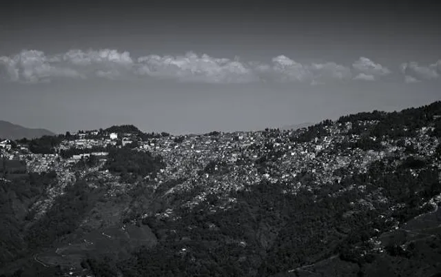
Nestled amidst the misty hills of Darjeeling district in West Bengal, India, Kurseong is a serene hill station that beckons travelers with its breathtaking vistas and tranquil ambiance. One of the highlights of visiting Kurseong is the opportunity to explore its numerous scenic vantage points, each offering a unique perspective of the surrounding landscape. With the assistance of Google Maps, navigating these picturesque spots becomes a seamless and enjoyable experience, ensuring that travelers can make the most of their journey through the hills.
Eagle's Crag Viewpoint: Perched atop a steep cliff, the Eagle's Crag Viewpoint offers sweeping panoramas of Kurseong town and the verdant valleys below. Accessing this iconic destination is made effortless with Google Maps, which provides detailed navigation routes tailored to the preferences of the traveler. Whether embarking on a scenic drive along winding mountain roads or opting for a leisurely hike through the lush terrain, Google Maps ensures that travelers can reach the viewpoint with ease. Additionally, real-time updates on traffic conditions and alternative routes enable travelers to adjust their plans accordingly, ensuring a smooth and hassle-free journey.
Ambootia Tea Estate Viewpoint: For those interested in immersing themselves in Kurseong's rich tea culture, the Ambootia Tea Estate Viewpoint offers an enchanting experience amidst sprawling tea gardens. Google Maps serves as a valuable tool for locating the tea estate and planning the visit, providing insights into nearby attractions, dining options, and amenities. With turn-by-turn navigation and offline accessibility features, travelers can explore the tea gardens at their own pace, learning about the tea-picking process and sampling freshly brewed Darjeeling tea along the way. Google Maps enhances the experience by highlighting scenic stops and points of interest, allowing travelers to make the most of their visit to this picturesque destination.
Devi Sthan Viewpoint: Tucked away in the tranquil outskirts of Kurseong, the Devi Sthan Viewpoint offers a serene retreat amidst pristine natural surroundings. Google Maps guides travelers along the scenic route to this hidden gem, providing valuable assistance in navigating through forest trails and winding mountain roads. Whether traveling by car or opting for a leisurely stroll, Google Maps ensures that travelers can reach the viewpoint safely and efficiently. Moreover, the app offers insights into nearby attractions and amenities, empowering travelers to make informed decisions during their exploration.
In conclusion, Google Maps serves as an indispensable companion for exploring Kurseong's scenic vantage points, offering reliable navigation, real-time updates, and personalized recommendations. With its user-friendly interface and comprehensive features, Google Maps enhances the travel experience, allowing travelers to uncover the hidden treasures of Kurseong with convenience and peace of mind. Let Google Maps be your guide as you embark on a journey of discovery through the breathtaking landscapes...
Read moreKurseong is a small hill town in the Indian state of West Bengal. Its viewpoint provides a panoramic view of the surrounding landscapes and offers a captivating experience for visitors. The viewpoint in Kurseong showcases the mesmerizing beauty of the nearby tea gardens, lush green forests, and the majestic snow-capped Himalayan ranges in the distance.
From the viewpoint, one can witness the sprawling tea estates that cover the hillsides, creating a picturesque setting. The sight of the neatly arranged tea bushes, with their vibrant green color, is a treat for the eyes. The viewpoint also offers a glimpse into the traditional tea cultivation methods followed in the region.
Apart from the tea gardens, the viewpoint allows visitors to appreciate the natural beauty of Kurseong's hilly terrain. The town is nestled amidst the hills and offers breathtaking views of the valleys and mountains. The gentle slopes covered with dense forests and the occasional waterfalls cascading down the hills add to the charm of the scenery.
From the viewpoint, one can also catch a glimpse of the Himalayan ranges, including the majestic Kanchenjunga peak. The snow-covered peaks stand tall in the distance, creating a spellbinding sight for visitors. The vibrant colors of the sky during sunrise or sunset enhance the beauty of the mountains, making it a perfect spot for photography enthusiasts.
Overall, the viewpoint in Kurseong provides a serene and peaceful ambiance where visitors can immerse themselves in the splendid beauty of nature. It offers a rejuvenating experience and is a popular destination for tourists seeking a break from the hustle and bustle...
Read more


&promo_pic=/hotel-sample/coolest.webp)


