Lewa Wildlife Conservancy, located in northern Kenya at the foothills of Mount Kenya, offers a powerful combination of conservation success, scenic beauty, and responsible tourism. Its map reflects not only the ecological richness of the area but also the thoughtful zoning and infrastructure that support both wildlife and community development. With around 250 square kilometers of protected land, the map provides a window into a model conservancy that blends safari with sustainability.
At first glance, the map of Lewa reveals a landscape of rolling savannahs, forested valleys, swampy wetlands, and acacia thickets. These habitats are clearly delineated with subtle color variation and topographic contours. The Ngare Ndare Forest, a lush corridor linking Lewa to Mount Kenya National Park, is often marked prominently, showcasing the conservancy’s key role in the broader Laikipia-Samburu ecosystem.
Running through the conservancy is a network of well-planned roads and game tracks, designed for minimal disturbance to wildlife. The map typically highlights:
Main gates such as Lewa Main Gate and Meru Gate
Airstrip (Lewa Downs Airstrip) for chartered flights, a crucial access point
Key wildlife corridors, including those linking to Borana Conservancy to the west
Observation points and waterholes strategically placed for game viewing
Perhaps the most impactful feature of the map is its wildlife tracking zones. Lewa is renowned for being one of Kenya’s most secure strongholds for black and white rhinos, and maps often feature rhino tracking areas, some with radio tower locations used for monitoring. These zones highlight how conservation technology and ranger operations are integrated into the landscape.
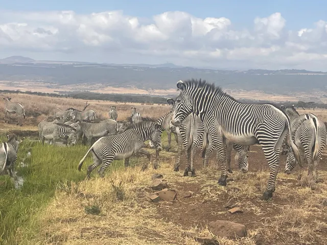
The conservancy is home to over 70 animal species and over 350 bird species. Special icons or shaded zones usually mark frequent sighting areas for:
Grevy’s zebra (Lewa holds one of the largest remaining populations)
Black rhino
Reticulated giraffe
Lions, leopards, and cheetahs
Elephants using migratory corridors northward into Samburu and south toward Mount Kenya
The map also showcases Lewa’s community projects and education centers, such as the Lewa Education Centre, community schools, and health clinics, reflecting the conservancy’s holistic approach to conservation. These sites are often plotted on the periphery, indicating partnerships with surrounding communities.
Key lodges and camps are clearly marked and linked by internal roads:
Lewa Safari Camp
Kifaru House
Sirikoi Lodge
Elewana Lewa Wilderness These camps are placed in zones of high ecological value, often near water points or wooded areas, and the map helps travelers plan game drives or guided walks accordingly.
Elevated areas such as Matunda Hill, Ngare Ndare ridge, and forested escarpments are shown with contour lines, offering lookout points over the plains—key for sundowners or panoramic wildlife viewing.
A noteworthy inclusion on most maps is the security fencing and guarded boundaries, which are not meant to restrict wildlife but to protect against poaching. Certain sectors are fitted with high-tech surveillance, and the map may indicate ranger posts and access roads used during anti-poaching patrols.
In summary, the map of Lewa Wildlife Conservancy communicates more than just navigation—it reflects a balanced coexistence between conservation, tourism, and community development. It’s well-organized, highly readable, and purposefully laid out to highlight how a private conservancy can be both a refuge for endangered species and a thriving model of sustainable land use. For the visitor, it offers assurance of safety, a variety of habitats to explore, and the rare opportunity to be part of one of Africa’s most celebrated conservation...
Read more