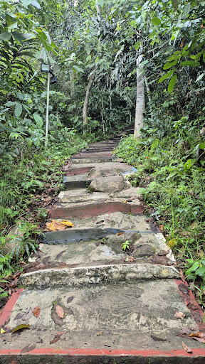
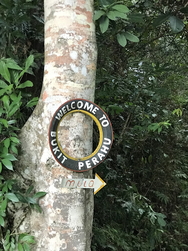
Bukit Perahu in Tamparuli is one of the most popular hiking spots among locals. It's free and very well maintained. There are paved steps along the main trail, which makes it convenient. The trail is short in distance but quite steep. You’ll reach the top in around 30 to 40 minutes. I recommend starting before 5 a.m. to catch the sunrise view at the top.
There's also a new alternative route, which is longer and unpaved, if you're looking for a more challenging hike. It's located to the right at the beginning of the stairs and is marked with a laminated white paper, so it shouldn't be hard to find.
Please note that the Eastern Trail, which is still visible on Google Maps, is no longer accessible due to a landslide. However, you can still hike down from the top until the point where the trail collapsed—it still offers a good 15–20 minutes of jungle trekking experience.
Don't forget to check out the trail to Batu Perahu (a rock that looks like a ship hull).
Note: There is no toilet or water here, so it's better to finish your "business" in town before starting the hike. If you plan to camp here, don't forget to bring extra water—and most importantly, take all your waste back down with you. Oh, and yes—I think this place is perfect...
Read moreGreat hike. Climbed on 30 June 2025. You start at the temple and walk uphill before encountering the steps. As someone who has never hiked and not the fittest, it was difficult. Some steps are knee high, and there's a relatively steep part where you can find a rope to help you. It took me around an hour to get to the top, though I took many short breaks. I started climbing at arpund 4.50am to make it in time for the sunrise. If you plan to catch the sunrise, bring a torchlight or use your phone torch as you'll likely start your hike in the dark. The steps can get a bit slippery with the leaves. I think its a good experience for anyone who wants to try something new :) The views at the top are gorgeous and rewarding. I reached around sunrise and it was beautiful seeing the lights from the town & also a little bit of Mount Kinabalu. It was rather cloudy & it got pretty cold. Its a pretty popular spot to hike and there were many locals...
Read moreParking space is limited, you can park like 10- 15 cars for now, and more space for bikes. Recommended parking at the town area which is like 1km away. For those who don't know, the entrance pathway to the hiking trail is near the new temple, right beside the signboard that says St. Veronica's Hill. The trail is very clean and safe. There are concrete pathways and stairs all over the way to the top. There are a few checkpoints along the way, and some viewing points with magnificent views. Hiking difficulty is maybe mid level, with some stairs elevation up to maybe 55 to 60 degree. The hill is 270m above sea level, with 1106 steps from...
Read more