Langtang National Park is a national park in north-central Nepal. It was established in 1976 as Nepal's first Himalayan national park and the country's fourth protected area. It covers an area of 1,710 km2 (660 sq mi) in the Nuwakot, Rasuwa and Sindhulpalchok Districts of the central Himalayan region. It contains 26 village communities and includes the Langtang valley. In the north and east it is linked with Qomolangma National Nature Preserve in the Tibet Autonomous Region.1] The eastern and western boundaries follow the Bhote Koshi and the Trishuli river, respectively.[2]
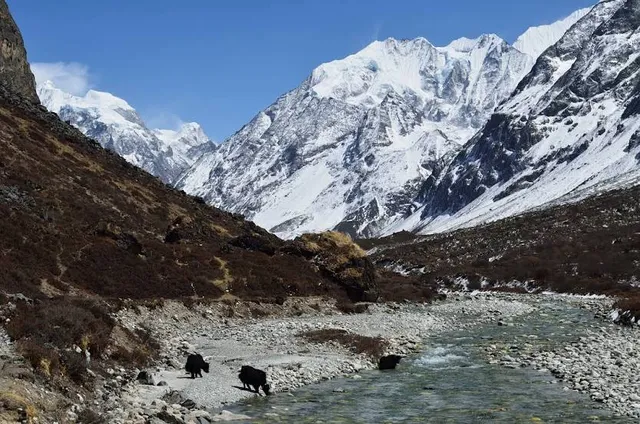
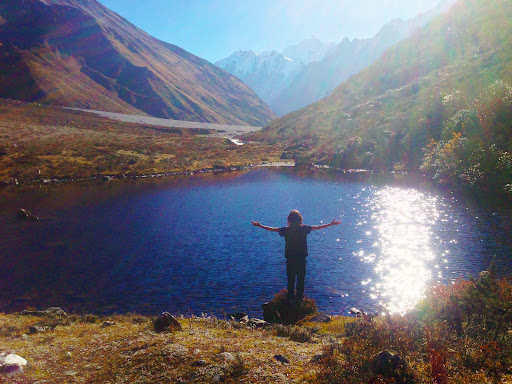
The Gosainkunda lake is located at an elevation of 4,300 m (14,100 ft) inside the park. The Dorje Lakpa range at 6,988 m (22,927 ft) bisects the park from west–east to south–east. The summit of Langtang Lirung is the highest point in the park at 7,245 m (23,770 ft).[3]
Langtang National Park is part of the Sacred Himalayan Landscape.[4]
History In 1970, royal approval designated the establishment of Langtang National Park as the first protected area in the Himalayas. The national park was gazetted in 1976 and extended by a buffer zone of 420 km2 (160 sq mi) in 1998.[1
On 31 July 1992, Thai Airways International Flight 311 crashed into the park. The Airbus A310 was on approach to Tribhuvan International Airport in Kathmandu. All 113 people on board were killed.[6]
In April 2015, the village of Langtang located within the park was destroyed by an avalanche of ice, rock and mud triggered by the April 2015 Nepal earthquake. At least 215 people were killed. In 2016, the International Astronomical Union named a 9.8km wide crater on Mars after the village, as a tribute.[7]
Climate
Sunrise in Langtang National Park
Gosainkunda Lake The climate of the park is dominated by the southwest summer monsoon; most of the annual precipitation occurs from June to September, and temperatures vary greatly due to the extreme difference in elevation.[8]
Flora and fauna Langtang National Park exhibits a high diversity of 14 vegetation types in 18 ecosystem types, ranging from upper tropical forests below 1,000 m (3,300 ft) m altitude to alpine scrub and perennial ice.[1]
References Bhuju, U. R.; Shakya, P. R.; Basnet, T. B. & Shrestha, S. (2007). Nepal Biodiversity Resource Book. Protected Areas, Ramsar Sites, and World Heritage Sites. Kathmandu: International Centre for Integrated Mountain Development, Ministry of Environment, Science and Technology, in cooperation with United Nations Environment Programme, Regional Office for Asia and the Pacific. ISBN 978-92-9115-033-5. Yonzon, P.; Jones, R.; Fox, J. (1991). "Geographic Information Systems for Assessing Habitat and Estimating Population of Red Pandas in Langtang National Park, Nepal". Ambio. 20 (7): 285–288. Mishra, P. N. (2003). "The Langtang National Park: a proposed first Biosphere Reserve in Nepal". Journal of the National Science Foundation of Sri Lanka. 31 (1&2): 333–335. doi:10.4038/jnsfsr.v31i1-2.3045. Gurung, C. P.; Maskey, T. M.; Poudel, N.; Lama, Y.; Wagley, M. P.; Manandhar, A.; Khaling, S.; Thapa, G.; Thapa, S.; Wikramanayake, E. D. (2006). "The Sacred Himalayan Landscape: Conceptualizing, Visioning, and Planning for Conservation of Biodiversity, Culture and Livelihoods in the Eastern Himalaya" (PDF). In McNeely, J. A.; McCarthy, T. M.; Smith, A.; Whittaker, O. L.; Wikramanayake, E. D. (eds.). Conservation...
Read moreThe Langtang National Park is the oldest Himalayan national park of Nepal and lies just north of Kathmandu and stretches till the Tibetan border. Throughout the National Park there are three main trekking routes: Langtang Valley, Helambu and Gosainkunda Lake. The park is therefore often visited by trekking groups and individuals.
Practical:
Size: 1710 Km2 Established: 1976 Best Season: September - November and March - May Park Main Entrance: Dhunche Location: Central Region
Climate
The climate of Langtang is in someway similar to Kathmandu. September to October are the best months for trekking as the rain chance is small and the temperatures are comfortable. December to February are the coldest months of the year, which may lead to occasional snowfall along the way. March till May also provide comfortable temperatures, but the visibility is not as great as in the Autumn period. By the end of March/start of April the Rhodondendron begins to blossom. The red, white and pink rhodondendron flowers form a fantastic colour spectrum with the green firs and oaks.
Flora and Fauna
Langtang has a diverse landscape where a total of eighteen different eco-systems can be observed, ranging from the Sal and Pine forests in the lowland, to the rough and rocky alpine landscape at high altitude. The flora conists of 1043 species of vascular plants of which 13 species, such as the Rhododendron Cownianum, R. Lowndesii and Larix Nepalensis are endemic. A large population of these plants grows in the various large high meadows spread over the park. Tree species in the park include the Rhododendron, Laurel, Blue Pine, Sal and Castanopsis Indica.
Within this rich flora, many animals have found there home. Forty-six mammals can be found in the Langtang National Park. Mammals to be found are the Red Panda, Snow Leopard, Clouded Leopard, Musk Deer and Himalayan Tahr. In addition 30 species of fish live within the park boundaries as well as 70 species of butterflies and 345 species of birds such as the Impeyan Pheasant, Ibis Bill, White-Winged Redstart and the Snow Patridge.
Areas of Interest
Throughout the Langtang National Park there are three main-trekking routes. These routes cover most different landscapes and also cover some cultural attractions. The main trekking routes are named: Langtang Valley Trek, Helambu Trek and the Gosainkunda Trek. The latter is also popular amongst local tourists as the Gosainkunda lake is religious site for Hindus. Hindus believe that the lake is an abode of lord Shiva. Lord Shiva himself has dug this like with his trident.
Activities
Langtang is pur sang a trekking destination and is best visited as integral part of a trekking. For more details on Trekking in the Langtang area please visit our page on Langtang Trekking.
Access
There are several ways to reach Langtang National Park. The most common, and leading to the park headquarters, is through the Trishuli Highway by bus or private vehicle. You can take the bus to Dhunche or you can take the bus even further to Syabru Besi. Another way to get into the Langtang National Park is to head from Kathmandu to Sundarijal (Shivapuri National Park) and start your hike from here and walk into the National Park. Sundarijal is also the starting point of the...
Read more"Exploring Langtang National Park: A Himalayan Gem of Nature and Culture"
Introduction: Langtang National Park is Nepals first Himalayan national park established in 1976. Located in the central Himalayan region it covers an area of 1710 km² across Nuwakot Rasuwa and Sindhupalchok districts. Known for its stunning landscapes rich biodiversity and cultural heritage it is a prime destination for trekking and nature enthusiasts.
Geographical Features: The park ranges from 1500 m to 7234 m Langtang Lirung peak. Features diverse terrains including lush forests alpine meadows, glaciers and highaltitude lakes like Gosainkunda. The Langtang Valley is often called the Valley of Glaciers due to its dramatic glacial formations.
Biodiversity: Flora Rhododendron oak pine and juniper forests alpine shrubs and medicinal herbs. Fauna Home to endangered species like the red panda snow leopard Himalayan black bear and langur monkeys. Over 250 bird species including the Himalayan monal and blood pheasant.
Tourism and Trekking: Popular for the Langtang Valley Trek Gosainkunda Trek and Tamang Heritage Trail. Offers a mix of adventure cultural experiences and scenic beauty. Less crowded than Everest and Annapurna regions providing a more serene trekking experience. Major stops include Kyanjin Gompa Langtang Village and sacred Gosainkunda Lake.
Socio-Cultural and Religious Significance: Inhabited by the Tamang and Sherpa communities with rich Tibetan Buddhist influences. Kyanjin Gompa and other monasteries hold spiritual importance. The annual Gosainkunda pilgrimage attracts thousands of Hindu and Buddhist devotees.
Climate Change Impact: Melting glaciers threaten water sources and biodiversity. Increased risk of landslides and flash floods due to erratic weather. Local communities face challenges in agriculture and livestock rearing.
Best Time to Visit: Spring, March-May: Blooming rhododendrons, clear skies, moderate temperatures Autumn, September- November: Stable weather, excellent visibility, ideal for trekking Monsoon, June-August: Heavy rainfall risk of landslides, less recommended Winter, December- February: Cold with snow at higher altitudes, suitable for experienced trekkers
How to Get There: By Road: 6-8 hours drive from Kathmandu to Syabrubesi, starting point for treks. By Flight No direct flights nearest airport is in Kathmandu Permits Required: TIMS card and Langtang National Park entry permit obtained in Kathmandu or Dhunche.
Final Thoughts: A perfect blend of natural beauty adventure and cultural richness. Less commercialized than other trekking regions offering an authentic Himalayan experience. Climate change poses a threat making sustainable tourism crucial. Highly recommended for trekkers wildlife lovers and those seeking...
Read more