Sagarmāthā National Park is a national park in the Himalayas of eastern Nepal that is dominated by Mount Everest. It encompasses an area of 1,148 km2 (443 sq mi) in the Solukhumbu District and ranges in elevation from 2,845 to 8,848 m (9,334 to 29,029 ft) at the summit of Mount Everest. In the north, it shares the international border with the Qomolangma National Nature Preserve of Tibet. In the east it is adjacent to Makalu Barun National Park, and in the south it extends to Dudh Kosi river.[1] It is part of the Sacred Himalayan Landscape.[2]
Sagarmatha National Park
IUCN category II (national park)

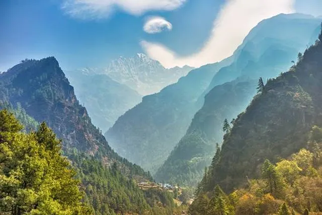
Landscape in the national park


Show map of Province No. 1Show map of NepalShow all
LocationProvince No. 1, NepalNearest cityNamche, KhumjungCoordinates27°56′N 86°44′EArea1,148 km2 (443 sq mi)EstablishedJuly 19, 1976Governing bodyDepartment of National Parks and Wildlife ConservationWebsitesagarmathanationalpark.gov.np
UNESCO World Heritage Site
CriteriaNatural: viiReference120Inscription1979 (3rd session)

Tengboche
Sagarmāthā is a Nepali word derived from सगर् sagar meaning "sky" and माथा māthā meaning "head".[3]
The protected area has been identified as an Important Bird Area by BirdLife International.[4]
HistoryEdit
Sagarmatha National Park was established in 1976. In 1979, it became the country's first national park that was inscribed as a Natural World Heritage Site. In January 2002, a Buffer Zone comprising 275 km2 (106 sq mi) was added.[1] Under the Buffer Zone Management Guidelines the conservation of forests, wildlife and cultural resources received top priority, followed by conservation of other natural resources and development of alternative energy.[5]
Tourism to the area began in the early 1960s. In 2003, about 19,000 tourists arrived. As of 2005, about 3,500 Sherpa people lived in villages and seasonal settlements situated along the main tourist trails.[6]
The park's visitor centre is located at the top of a hill in Namche Bazaar, where a company of the Nepali Army is stationed for protection of the park. The park's southern entrance is a few hundred metres north of Monzo at 2,835 m (9,301 ft), a one-day trek from Lukla.[7]
LandscapeEdit
The park contains the upper catchment areas of the Dudh Kosi river, Bhotekoshi river basin and the Gokyo Lakes. It is largely composed of rugged terrain and gorges of the high Himalayas, ranging from 2,845 m (9,334 ft) at Monjo to the top of the world's highest peak Sagarmatha (Mt. Everest) at 8,848 m (29,029 ft) above sea level. Other peaks above 6,000 m (20,000 ft) are Lhotse, Cho Oyu, Thamserku, Nuptse, Amadablam and Pumori. Barren land above 5,000 m (16,000 ft) comprises 69% of the park while 28% is grazing land and the remaining 3% is forested. Climatic zones include a forested temperate zone, a subalpine zone above 3,000 m (9,800 ft), and an alpine zone above 4,000 m (13,000 ft) that constitutes the upper limit of vegetation growth. The nival zone starts at 5,000 m (16,000 ft).[1]
VegetationEdit
In the lower forested zone, birch, juniper, blue pines, firs, bamboo and rhododendron grow. Above this zone the vegetation is dwarf-sized or comprises shrubs. As the altitude increases, plant life is restricted to lichens and mosses. Plants cease to grow at about 5,750 m (18,860 ft), because this is the permanent snow line in the Himalayas.[8]
Forests of pine and hemlock cover the lower elevations of the national park. At elevations of around 3,500 m (11,500 ft) and above, forests of silver fir, birch, rhododendron and juniper trees...
Read moreAccording to UNESCO-Including the highest point on the Earth’s Surface, Mount Sagarmatha (Everest; 8,848 m) and an elevation range of 6,000 m Sagarmatha National Park (SNP) covers an area of 124,400 hectares in the Solu-Khumbu district of Nepal. An exceptional area with dramatic mountains, glaciers, deep valleys and seven peaks other than Mount Sagarmatha over 7,000 m the park is home to several rare species such as the snow leopard and the red panda. A well-known destination for mountain tourism SNP was gazetted in 1976 and with over 2,500 Sherpa people living within the park has combined nature and culture since its inception.
Encompassing the infinitely majestic snow capped peaks of the Great Himalayan Range, the chain of mountains including the world’s highest Mt. Sagarmatha (Everest) and extensive Sherpa settlements that embody the openness of SNP to the rest of the world. The carefully preserved natural heritage and the dramatic beauty of the high, geologically young mountains and glaciers were recognized by UNESCO with the inscription of the park as a world heritage site in 1979. The property hosts over 20 villages with over 6000 Sherpas who have inhabited the region for the last four centuries. Continuing their traditional practice of cultural and religion including the restriction of animal hunting and slaughtering, and reverence of all living beings. These practices combined with indigenous natural resource management practices, have been major contributing factors to the successful conservation of the SNP.
The constantly increasing numbers of tourists visiting the property, 3,600 visitors in 1979 to over 25000 in 2010, has immensely boosted the local economy and standard of living with better health, education, and infrastructure facilities. One initiative of SNP has been to implement a buffer zone (BZ) program to enhance protection and management of the property and was motivated by a desire to enhance conservation in combination with improved socio-economic status of the local communities through a revenue plough back system. The SNP area is also the major source of glaciers, providing freshwater-based benefits for the people downstream. In addition to conservation of the values of the property a priority of the park is to monitor the impacts of global warming and climate change on flora, fauna and Sherpa...
Read moreSagarmāthā National Park is a national park in the Himalayas of eastern Nepal that was established in 1976 and encompasses an area of 1,148 km2 (443 sq mi) in the Solukhumbu District. It ranges in elevation from 2,845 to 8,848 m (9,334 to 29,029 ft) and includes Mount Everest. In the north, it shares the international border with Qomolangma National Nature Preserve in Tibet Autonomous Region. In the east, it is adjacent to Makalu Barun National Park, and in the south it extends to Dudh Kosi river.[1] It is part of the Sacred Himalayan Landscape.[2]
History
Entrance gate of the Sagarmatha National Park Sagarmatha National Park was established on July 19, 1976.[3] In 1979, it became the country's first national park that was inscribed as a Natural World Heritage Site. In January 2002, a Buffer Zone comprising 275 km2 (106 sq mi) was added.[1] Conservation of forests, wildlife, and cultural resources received top priority under the Buffer Zone Management Guidelines, followed by conservation of other natural resources and development of alternative energy.[4] Tourism in the area began in the early 1960s. In 2003, about 19,000 tourists arrived. As of 2005, about 3,500 Sherpa people lived in villages and seasonal settlements situated along the main tourist trails.[5]
Landscape Sagarmatha National Park contains the upper catchment areas of the Dudh Kosi and Bhotekoshi rivers and the Gokyo Lakes. It ranges in elevation from 2,845 m (9,334 ft) at Monjo to the top of Mount Everest at 8,848 m (29,029 ft). Other peaks above 6,000 m (20,000 ft) are Lhotse, Cho Oyu, Thamserku, Nuptse, Amadablam and Pumori. Barren land above 5,000 m (16,000 ft) comprises 69% of the park while 28% is grazing land and the remaining 3% is forested. Climatic zones span from temperate and subalpine above 3,000 m (9,800 ft) to alpine above 4,000 m (13,000 ft), which is the upper limit of vegetation growth. The nival zone begins at 5,000 m...
Read more