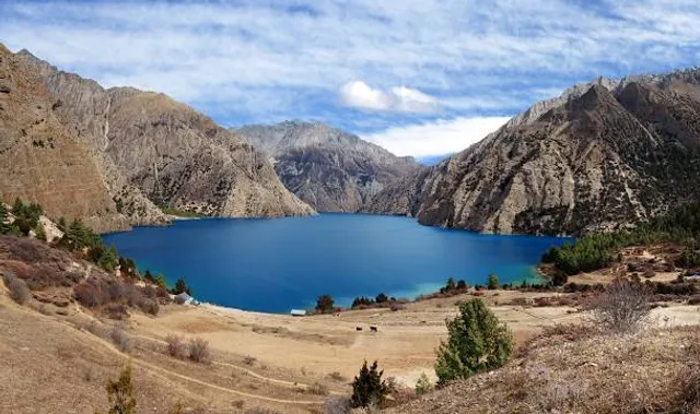
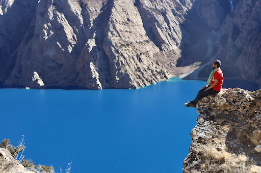
Shey Phoksundo National Park is the largest and only trans-Himalayan national park in Nepal. It was established in 1984 and covers an area of 3,555 km2 (1,373 sq mi) in the districts of Dolpa and Mugu in the Mid-Western Region, Nepal. The protected area ranges in elevation from 2,130 to 6,885 m (6,988 to 22,589 ft).1 Phoksundo Lake is the park's prominent feature, located at an elevation of 3,612 m (11,850 ft).[1]
The park's headquarters are in Palam, Dolpa District.
Geography 
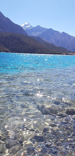
The park's elevation varies from 2,130 m (6,990 ft) in the southeast near Ankhe to 6,883 m (22,582 ft) at the summit of Kanjiroba Himal at the southern edge of the Tibetan plateau. Phoksundo Lake at an elevation of 3,660 m (12,010 ft) in the upper reaches of the Suligad river is surrounded by glaciers and is known for its turquoise color.[1]
Phoksundo Lake has a water surface of 494 ha (1,220 acres), and was declared a Ramsar site in September 2007.[3] The lake is up to 145 m (476 ft) deep, measured using echo-sounding technology.[4]
The Langu river drains the high Dolpo plateau located in the north-east of the park. The Suligad and Jugdual rivers form the southern catchment flowing south into the Thuli Bheri River.[5]
Ecology Fauna 90 snow leopards, with a density of 2.21 snow leopards per 100 km2, were found during the study conducted from 2019 to 2022 by Department of National Parks and Wildlife Conservation, supported by the World Wildlife Fund (WWF).[6] Other endangered species found in the park include grey wolf, musk deer, blue sheep, goral, great Tibetan sheep, Himalayan tahr, leopard and Himalayan black bear.
Culture Several gompas are within the park including Shey Gompa, which was established in the 11th century.[1]
References Bhuju, U. R.; Shakya, P. R.; Basnet, T. B.; Shrestha, S. (2007). Nepal Biodiversity Resource Book. Protected Areas, Ramsar Sites, and World Heritage Sites (PDF). Kathmandu: International Centre for Integrated Mountain Development, Ministry of Environment, Science and Technology, in cooperation with United Nations Environment Programme, Regional Office for Asia and the Pacific. ISBN 978-92-9115-033-5. GoN/MoFSC /2014). Nepal Biodiversity Strategy and Action Plan 2014-2020. Government of Nepal, Ministry of Forests and Soil Conservation, Kathmandu, Nepal Bhandari, B. B. (2009). "Wise use of wetlands in Nepal". Banko Janakari. 19 (3): 10–17. Anonymous (2004). Rara is Nepal's deepest lake: Survey. Nepalnews.com Majupuria, T. C.; Kumar, R. (1998). Wildlife, National Parks and Reserves of Nepal. Bangkok: S. Devi, Saharanpur and Tecpress Books. ISBN 974-89833-5-8. "Ninety endangered snow leopards recorded in Shey-Phoksundo National Park". kathmandupost.com....
Read more"Discovering Shey Phoksundo National Park: Nepal’s Remote Wilderness and Cultural Treasure" • Introduction: o Shey Phoksundo National Park, established in 1984, is Nepal’s largest national park, covering 3,555 km² in Dolpa and Mugu districts. Renowned for its remote wilderness, turquoise Phoksundo Lake, and Tibetan Buddhist culture, it’s a haven for adventurers and spiritual seekers. • Geographical Features : o Spans altitudes from 2,130 m to 6,885 m (Kanjirowa Himal). o Features Phoksundo Lake (Nepal’s deepest at 145 m), waterfalls, and rugged Trans-Himalayan landscapes. o Includes arid valleys, glacial rivers, and the Suligad River gorge. • Biodiversity: o Flora: Pine, juniper, and alpine meadows; rare medicinal herbs like yarsagumba. o Fauna: Snow leopards, blue sheep, musk deer, and over 200 bird species, including the Himalayan griffon. o Supports unique high-altitude ecosystems in a rain-shadow region.
• Tourism and Trekking: o Offers treks like the Upper Dolpo Trek and Phoksundo Lake Trek, known for challenging terrain and solitude. o Key attractions: Phoksundo Lake, Shey Gompa, and ancient Bon monasteries. o Basic teahouses available; restricted area permits cost $90 for 10 days.
• Socio-Cultural and Religious Significance o Home to Bon and Tibetan Buddhist communities with ancient monasteries like Shey Gompa. o The Crystal Mountain is a sacred pilgrimage site for Buddhists. o Festivals like Yartung celebrate local traditions, blending Bon and Buddhist practices.
• Climate Change Impact : o Glacial retreat and erratic snowfall threaten water sources and pastures. o Overgrazing and herb collection strain fragile ecosystems. o Community-led conservation promotes sustainable practices to mitigate impacts.
• Best Time to Visit: o Spring (Mar-May): Mild weather, blooming flora, clear trails. o Autumn (Sep-Nov): Stable conditions, ideal for trekking and views. o Monsoon (Jun-Aug) brings heavy rain, making access difficult.
• How to Get There: o Fly from Kathmandu to Nepalgunj, then Juphal (1.5 hrs total, ~$200-$300). o Trek from Juphal to Dunai (park entry, 2-3 hrs). o Restricted area permits required, obtainable in Kathmandu. • Final Thought: o Shey Phoksundo National Park is a remote paradise blending dramatic landscapes, rich biodiversity, and...
Read moreShey Phoksundo National Park provides a diversity of spectacular landscapes and ranks among the most scenic mountain parks in the world. Much of the park lies north of the Himalayan crest. Elevations range from 2,130 m (6,990 ft) in the southeast near Ankhe to 6,883 m (22,582 ft) at the summit of Kanjiroba Himal, which lies at the southern edge of the Tibetan plateau. Phoksundo Lake lies at an elevation of 3,660 m (12,010 ft) in the upper reaches of the Suligad river. It is surrounded by glaciersand famous for its magnificent turquoise color. Near the lake’s outlet is the country’s highest waterfall.[1] Phoksundo Lake has a water surface of 494 ha (1,220 acres), and was declared a Ramsar site in September 2007.[3] The lake is up to 145 m (476 ft) deep, measured using echo-sounding technology.[4] The Langu river drains the high Dolpo plateau located in the north-east of the park. The Suligad and Jugdual rivers form the southern catchment flowing south into the Thuli Bheri river. Spanning the northern and southern aspects of the Himalayan crest, the park experiences a wide climatic range and lies in the transition zone from a monsoon dominated to an arid climate. Annual precipitation reaches 1,500 mm (59 in) in the south, whereas on northern slopes less than 500 mm (20 in) of rain falls. Most of the precipitation occurs during monsoon from July to September. The Dhaulagiri and Kanjiroba massifs form a massive barrier preventing most of the rain from reaching the Trans-Himalayan area. Winters are quite severe with frequent snowfalls above 2,500 m (8,200 ft) and temperatures remaining below freezing above 3,000 m (9,800 ft) through much...
Read more