The Shuklaphanta National Park is a protected area in the Terai of the Far-Western Region, Nepal, covering 305 km2 (118 sq mi) of open grassland, forests, riverbeds and tropical wetlands at an altitude of 174 to 1,386 m (571 to 4,547 ft).1] It was gazetted in 1976 as Royal Shuklaphanta Wildlife Reserve. A small part of the reserve extends north of the East-West Highway to create a corridor for seasonal migration of wildlife into the Sivalik Hills. The Syali River forms the eastern boundary southward to the international border with India, which demarcates the reserve’s southern and western boundary.[2]
The Indian Tiger Reserve Kishanpur Wildlife Sanctuary is contiguous in the south; this coherent protected area of 439 km2 (169 sq mi) represents the Tiger Conservation Unit (TCU) Sukla Phanta-Kishanpur, which covers a 1.897 km2 (0.732 sq mi) block of alluvial grasslands and subtropical moist deciduous forests.[3]
The protected area is part of the Terai-Duar savanna and grasslands ecoregion and is one of the best-conserved examples of floodplain grassland.[4] It is included in the Terai Arc Landscape.The area was a favorite hunting ground for Nepal's ruling class and was declared a Royal Hunting Reserve in 1969. In 1973, the area was gazetted as Royal Sukla Phanta Wildlife Reserve, initially comprising 155 km2 (60 sq mi), and extended to its present size in the late 1980s.[6] A buffer zone of 243.5 km2 (94.0 sq mi) was added in May 2004.[1] In 2017, the status of the protected area was changed to a national park.
The name Suklaphanta was derived from one of the grasslands found inside the protected area.[7] The main grassland called Sukla Phanta is the largest patch of continuous grassland in Nepal covering an area of about 16 km2 (6.2 sq mi).[2]
The jungles of the Shuklaphanta National Park were once the site of an ancient kingdom. To this day, ruins of that kingdom can be seen in some places. Near Rani Tal, a lake in the reserve, there still remains a brick girdle, measuring 1,500 m (59,000 in) in circumference. It is considered by locals to be a remnant of the fort of Tharu king Singpal.[8]
Climate The climate of the region is subtropical monsoonal with mean annual rainfall of 1,579 mm (62.2 in) that occurs from June to September and is highest in August. The winter months of December and January are fairly cold with daytime temperatures of 7–12 °C (45–54 °F) and occasional frost. From February onwards temperatures rise up to 25 °C (77 °F) in March and reach 42 °C (108 °F) by end of April. When the first pre-monsoon rains reach the area in May, humidity increases.[6
Vegetation
Imperata cylindrica is one of the main grass species found in the park's phantas Some 700 species of flora are estimated in the park including 553 vascular plants, 18 pteridophytes, 410 dicots and 125 monocots.[1] Grassland constitutes almost half the reserve's vegetation. The main grass species are Imperata cylindrica and Heteropogon contortus. khagra reed (Phragmites karka) and Saccharum spontaneum grow in the marshes surrounding the seven small lakes. The dominant forest type is sal. Khair and sissoo grow alongside rivers. Grassland encroachment by tree and shrub saplings are major threats to the long-term existence of the main phantas. Trees outcompete any grasses growing under them, especially those that need plenty of sunlight. Tree seeds are dispersed all over the grasslands and generally germinate near existing trees. Additionally, trees encourage the growth of shade-loving grasses and inhibit growth of sun-loving species. This process of succession usually converts grassland into...
Read more"Shuklaphanta National Park: Nepal’s Terai Treasure of Grasslands and Wildlife"
= Introduction
Located in the Terai region of far-western Nepal, established in 1976 as a wildlife reserve, upgraded to a national park in 2017. Covers 305 sq km in Kanchanpur district, extending to India’s border. Named after the vast Shukla Phanta grassland, the largest continuous grassland in Nepal’s Terai. 
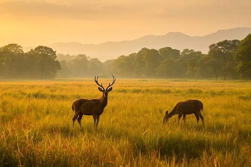
Known for its rich biodiversity, especially swamp deer (barasingha) populations.
= Geographical Features
Flat Terai landscape with grasslands, wetlands, rivers, and sal forests. Key features: Shukla Phanta grassland, Rani Tal lake, Mahakali River. Elevation: 174–1,386 meters, with tropical and subtropical ecosystems. Borders India’s Dudhwa National Park, forming a transboundary conservation area.
= Biodiversity
Flora: Sal forests, khair-sissoo forests, grasslands; supports tropical and subtropical vegetation 
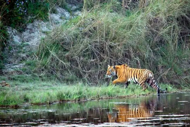
Fauna: Large populations of swamp deer (largest in Nepal), Bengal tiger, Indian leopard, Asian elephant Other mammals: Spotted deer, hog deer, nilgai, wild boar, sloth bear Reptiles: Gharial, mugger crocodile, Indian rock python Birds: Over 424 species, including Bengal florican, sarus crane, white-rumped vulture, and migratory birds like great slaty woodpecker Notable for 10 of Nepal’s 12 protected bird species
= Tourism and Activities
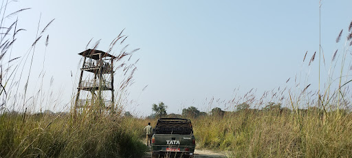
Jungle Safaris: Jeep and elephant-back safaris for wildlife viewing. Birdwatching: Popular for rare and migratory species. Camping and Nature Walks: Guided tours in buffer zones. Cultural Sites: Nearby Tharu villages offer cultural experiences. Best Spots: Rani Tal for birdwatching, Shukla Phanta for deer spotting.
= Socio-Cultural Significance
Home to indigenous Tharu and other local communities. Tharu culture visible in traditional dances, festivals, and livelihoods. Buffer zone communities engaged in eco-tourism and conservation. Conservation efforts balance human-wildlife coexistence.
= Climate Change and Conservation Challenges
Threats: Poaching, human-wildlife conflict, grassland encroachment Climate impacts: Altered rainfall patterns, flooding risks to wetlands Conservation: Anti-poaching patrols, community-based programs, transboundary cooperation with India Recent success: Growing swamp deer and tiger populations
= Best Time to Visit
Autumn/Winter (Oct-Feb): Cool weather, clear skies, ideal for safaris and birdwatching Spring (Mar-May): Pleasant temperatures, blooming flora Monsoon (Jun-Sep): Heavy rains, flooding; limited access but lush greenery
= How to Get There
By Air: Fly from Kathmandu to Dhangadhi (1 hr), then drive to the park (1–1.5 hrs) By Road: From Kathmandu to Mahendranagar (12–14 hrs), then to park gate (30–45 mins) Local Access: Buses or private vehicles from Dhangadhi or Mahendranagar Permits: National Park entry permit (NPR 3,000 for foreigners, NPR 1,500 for SAARC)
= Final Thoughts
Pros: Rich biodiversity with rare species like swamp deer and Bengal florican Less crowded than Chitwan or Bardia, offering a peaceful experience Combines wildlife, birdwatching, and Tharu cultural immersion
-Cons: Limited tourist infrastructure (basic lodges, fewer luxury options) Remote location requires long travel...
Read moreShuklaphanta National Park is a protected area in the Terai of the Far-Western Region, Nepal, covering 305 km2 (118 sq mi) of open grassland, forests, riverbeds and tropical wetlands at an altitude of 174 to 1,386 m (571 to 4,547 ft).[1] It was gazetted in 1976 as Royal Shuklaphanta Wildlife Reserve. A small part of the reserve extends north of the East-West Highway to create a corridor for seasonal migration of wildlife into the Sivalik Hills. The Syali River forms the eastern boundary southward to the international border with India, which demarcates the reserve’s southern and western boundary.[2]
Shuklaphanta National Park
IUCN category II (national park)

Rani Tal, a lake inside Shuklaphanta National Park


LocationNepal, Province No. 7Nearest cityBhimdattaCoordinates28°50′N 80°14′EArea305 km2 (118 sq mi)Established1976 as Wildlife Reserve, 2017 as National ParkGoverning bodyDepartment of National Parks and Wildlife Conservation
The Indian Tiger Reserve Kishanpur Wildlife Sanctuary is contiguous in the south; this coherent protected area of 439 km2(169 sq mi) represents the Tiger Conservation Unit (TCU) Sukla Phanta-Kishanpur, which covers a 1.897 km2 (0.732 sq mi) block of alluvial grasslands and subtropical moist deciduous forests.[3]
The protected area is part of the Terai-Duar savanna and grasslands ecoregion and is one of the best-conserved examples of floodplain grassland.[4] It is included in the Terai Arc Landscape.[5]
HistoryEdit
The area was a favorite hunting ground for Nepal's ruling class and was declared a Royal Hunting Reserve in 1969. In 1973, the area was gazetted as Royal Sukla Phanta Wildlife Reserve, initially comprising 155 km2(60 sq mi), and extended to its present size in the late 1980s.[6] A buffer zone of 243.5 km2(94.0 sq mi) was added in May 2004.[1] In 2017, the status of the protected area was changed to a national park.
The name Suklaphanta was derived from one of the grasslands found inside the protected area.[7] The main grassland called Sukla Phanta is the largest patch of continuous grassland in Nepal covering an area of about 16 km2 (6.2 sq mi).[2]
The jungles of the Shuklaphanta National Park were once the site of an ancient kingdom. To this day, ruins of that kingdom can be seen in some places. Near Rani Tal, a lake in the reserve, there still remains a brick girdle, measuring 1,500 m (59,000 in) in circumference. It is considered by locals to be a remnant of the fort...
Read more