Nicaragua’s largest lake has several names: the indigenous tribes called it Cocibolca and the Spanish conquerors named it La Mar Dulce (both terms meaning Sweet Sea), the people from Granada call it Lake Granada and it is nowadays generally known as Lake Nicaragua.
Lake Nicaragua is also the largest lake in Central America, the 10th largest lake in the Americas and the 19th largest lake in the world (by area).
Oval in shape, with an area of 8,264 square km (3,190.75 square miles), the lake is 177 km (110 miles) in length and has an average width of 58 km (36 miles). It is about 18 meters (59 feet) deep in the centre, and its waters reach a depth of 60 meters (197 feet) to the southeast of its largest island, Ometepe. The lake’s surface is about 30 meters (98.5 feet) above sea level.
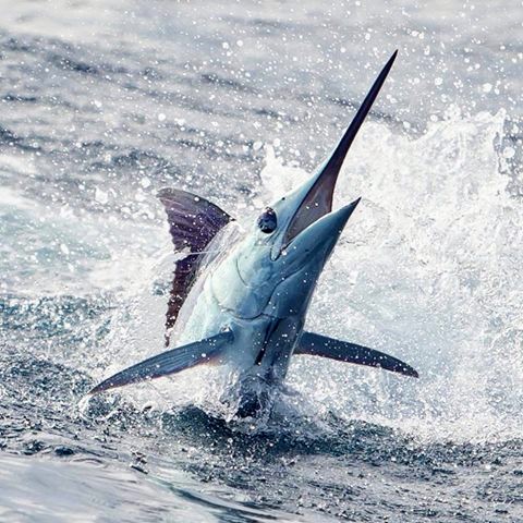
It is believed that Lake Nicaragua, together with Lake Managua to the northwest, originally formed part of an ocean bay that, as a result of volcanic eruption, became an inland basin containing the two lakes, which are linked by the Tipitapa River. The ocean fishes thus trapped adapted themselves as the salt water gradually turned fresh (or they were able to jump along the rapids of the San Juan River — which connects Lake Nicaragua with the Caribbean Sea — like some scientists have discovered in the late 1960s). Lake Nicaragua is the only freshwater lake containing oceanic animal life, including bull shark, swordfish, sawfish and tarpon...
More than 40 rivers drain into the lake, the largest being the Tipitapa River. The San Juan River drains out of the lake, following a 180 kilometers (112 miles) course that runs from the southeastern shore of the lake through a densely forested region to empty into the Caribbean Sea. For part of its course, the San Juan forms the boundary between Nicaragua and Costa Rica. To the southwest, the lake is separated from the Pacific Ocean by a narrow land corridor, the Rivas Isthmus, which is 19 kilometers (12 miles) wide.
Surface water temperature usually remains about 24°C (in the mid-70s F), and bottom temperature stays about 16°C (in the low 60s F). Due to the chemical composition of the volcanic rocks forming parts of the lake’s bed and shores, the lake waters contain high proportions of dissolved magnesium and potassium salts.
There are more than 400 islands in the lake, around 300 of which are within 8 kilometers (5 miles) of the city of Granada on the northwest shore. Most of the islands are covered with a rich growth of vegetation, which includes tropical fruit trees. Some of the islands are inhabited, including the bigger ones like Ometepe, Zapatera and Solentiname Islands. The biggest Ometepe is 26 kilometers (16 miles) long and 13 kilometers (8 miles) wide. It is formed of what originally were two separate volcanoes—Concepción, which is 1,610 metres (5,282 feet) high and last erupted in 1983, and Madera, which is 1,394 metres (4,573 feet) high. Lava from bygone eruptions forms a bridge between them, called the Tistian Isthmus. A third volcano associated with the lake is Mombacho, about 1,350 metres (4,429 feet) high, which stands on the western shore.
In recent years, a considerable concern has been expressed about the ecological condition of Lake Nicaragua, as its water was being seriously polluted by raw sewage released into the lake daily...
Photos courtesy of Internet and...
Read more