Uno de los mejores lugares para realizar trecking.
PARA IR POR CUENTA PROPIA: tomas un bus hasta Yungay, debes llegar temprano, plan 07:00 am, a una cuadra de su plaza se encuentra el mercado, desayunas y te aprovisionas de comestibles para la ruta, debes llevar agua y tu almuerzo, recomendable el uso de frutos secos. Luego debes dirigirte al terminal terrestre de Yungay, aproximadamente a una o dos cuadras del mercado, hay unas combis que te llevan hasta Cebollapampa (punto de inicio de la caminata) el costo es de 25 soles, tambien hay taxis para los que puedan solventarlo, y es recomendable llegar temprano (07:30 am a mas tardar) porque la combi se llena y parte, y luego tendras que volver a esperar que se llene de pasajeros, y puedes perder 2 horas en ese lapso.
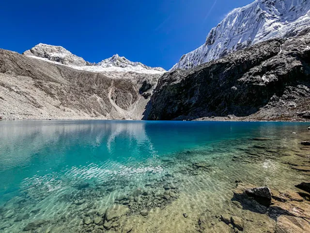
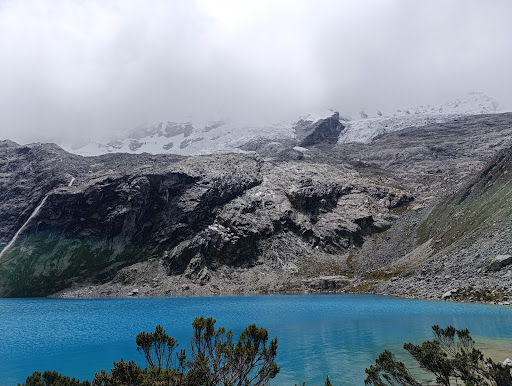
Aproximadamente son 2 horas de viaje hasta Cebollapampa, antes se pasa una caseta de control para el pago por derecho de ingreso al Parque Nacional Huascaran (12 soles para nacionales) tambien venden algunos comestibles ligeros en este punto (agua, galletas, choclo y queso, etc) luego llegas a la Laguna Llanganuco (te puedes tomar foto con los arboles queñuales), otra laguna mas pequeña y finalmente a unos 5-10 minutos llegas a Cebollapampa; existen zonas de camping en este punto y tambien hay implementado un restaurante con venta de comida. Inicias la caminata que dura en promedio 3 horas (dependiendo del estado fisico y aclimatacion de cada persona), si bien no hay abundancia de señales en la ruta, el sendero se encuentra demarcado por la huella de los viajeros, el paisaje es muy bonito, apreciarás lagunillas, el rio, a la distancia se aprecian caidas de agua; existe un punto casi intermedio donde se encuentra la Laguna "Consuelo", llamada asi porque muchos desisten en este punto para continuar con la ruta, aproximadamente a una hora de caminata se ubica la "Laguna 69", su aguas son aturquesadas, y provienen directamente del deshielo del nevado, en este punto se pueden apreciar los nevados circundantes, un panorama muy bonito e impactante.
La ruta de regreso convencional es por el mismo camino; aunque tambien existe otra ruta (llamado "El Paso del Condor") que es desde la Laguna 69 hacia el Refugio Peru, es de ascenso, y el descenso es desde el Refugio Peru hasta Cebollapampa ( o viceversa) y se requiere buen estado fisico, llevar implementos adecuados y - en mi opinion - orientarse bien en esta ruta, por que no hay señales en el camino, casi todos se guian por el sendero demarcado por el paso de los caminantes o por las abra apacheta que existen en la ruta, a modo de orientacion, pero hay trechos angostos y partes de caminos con rocas que podrian desorientar a quien no está acostumbrado a este tipo de rutas.
Recomendaciones e implementos a usar: Bastones de trecking, gorrro o sombrero, gorro para el frio, lentes para el sol, bloqueador, hidratación, algun hidratante para la resequedad en los labios, alimentación porque en la ruta no venden absolutamente nada; calzado adecuado para trecking (botines) .Importante ver el pronostico del clima, para que la lluvia no se sorprenda, de lo contrario deberás llevar impermeable, lo ideal es ir en temporada seca (mediados de mayo a setiembre). Para retornar desde Cebollapampa hasta Yungay (en mi caso) me aseguré de retornar lo mas temprano posible desde la Laguna 69 hasta Cebollapampa, llegué a las 13:50 aproximadamente, donde pude encontrar 2 movilidades que tenian disponibilidad de asientos libres, pero tenian que esperar que sus pasajeros retornen de la caminata procedentes de la Laguna 69, asi que decidí pactar con uno de ellos, asegurar mi asiento y mientras caminar hacia la Laguna Llanganuco para sacar algunas fotos (aprox. 2 kms), luego esperé en la carretera a la movilidad pactada, tambien pude apreciar que eventualmente pasaron dos combis con disponibilidad de asiento para retorno a Yungay. La afluencia de estos vehiculos es mas frecuente los fines de semana o feriados que mayor cantidad de personas visita este lugar, asi que si vas dias particulares o laborables deberas ser mas...
Read more