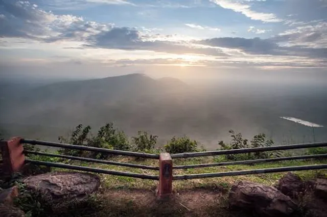
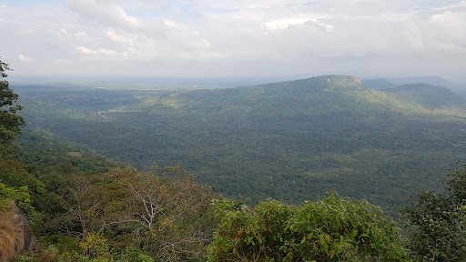
ผามออีแดง ตั้งอยู่ในพื้นที่อุทยานแห่งชาติเขาพระวิหาร ตำบลเสาธงชัย อำเภอกันทรลักษ์ จังหวัดศรีสะเกษ อยู่บริเวณใกล้เคียงกับทางเดินขึ้นปราสาทเขาพระวิหาร เป็นหน้าผาสูงชันกั้นเขตแดนประเทศไทยกับประเทศกัมพูชา ตลอดแนวผามออีแดงมีระยะประมาณ 300 เมตร เป็นจุดชมวิวที่มองเห็นทัศนียภาพของแผ่นดินประเทศกัมพูชาที่อยู่ต่ำลงไปอย่างเป็นมุมกว้าง มีฝูงค้างคาวในยามพระอาทิตย์ตกดิน บริเวณใกล้เคียงมีเส้นทางศึกษาธรรมชาติ ชมโบราณสถานสถูปคู่รูปทรงสี่เหลี่ยมลูกบาศก์ ส่วนบนกลมข้างในเป็นโพรง สำหรับบรรจุสิ่งของสร้างด้วยหินทรายแดง ขนาดกว้าง 1.93 เมตร ยาว 4.2 เมตร ซึ่งเชื่อกันว่าเป็นสัญลักษณ์ของความอุดมสมบูรณ์
ผามออีแดงเป็นจุดชมทัศนียภาพระหว่างเส้นทางขึ้นสู่เขาพระวิหาร มีลักษณะเป็นหินผาสูงชันและเป็นที่ตั้งหน่วยปฏิบัติของทหารพราน ที่ผามออีแดง สามารถชมปราสาทเขาพระวิหาร และประเทศกัมพูชาธิปไตย ทางหน้าผาทิศใต้พบภาพแกะสลักนูนต่ำบนแผ่นหินรูปพระศิวะ พระอุมา และพระนารายณ์ เป็นศิลปของ อายุราว พุทธศตวรรษที่ 14
ประวัติความเป็นมาของผามออีแดง
ก่อนที่คณะของท่านจะผ่านเส้นทางขึ้นมาท่านจะต้องผ่านหมู่บ้านสุดท้ายตั้งอยู่ติดชายแดน คือ บ้านภูมิซรอล ภูมิ แปลว่า บ้าน ซรอล แปลว่า ต้นสน ระยะทางจากภูมิซรอล ถึง ผามออีแดง 11 กิโลเมตร ผามออีแดงเป็นเนินหน้าผาสูงลาดชัน 45 องศา หรือเดิมเรียกว่าเนิน 45 เมื่อปี พ.ศ. 2504 ได้มีคณะครูแดงจำนวน 30 คน ได้เดินทางมาเที่ยวทัศนศึกษาที่ปราสาทเขาพระวิหาร รถของคณะครูแดงได้ประสบอุบัติเหตุบริเวณเนิน 45 จึงทำให้ครูแดงเสียชีวิต และได้มาปรากฏกายให้เจ้าหน้าที่พบเห็นบ่อยครั้ง จึงเป็นที่เล่าขานกันมา และเรียกติดปากกันมาจนเป็นตำนาน “ผามออีแดง” จนถึงปัจจุบัน
ภาพสลักนูนต่ำ
บริเวณผามออีแดง มีภาพแกะสลักนูนต่ำเป็นภาพคน 3 คน ในเครื่องแต่งกายแบบชาวกัมพูชา สร้างขึ้นก่อนปราสาทเขาพระวิหาร ราวกลางศตวรรษที่ 11 อายุประมาณ 1,500 ปี มีโบราณวัตถุ (พระพุทธรูปนาคปรก) บริเวณจุดสูงสุดของผามออีแดงสามารถมองเห็นทัศนียภาพของปราสาทเขาพระวิหารได้อย่างชัดเจน
ธงชาติไทย
ผามออีแดง เป็นที่ตั้งของเสาธงชาติไทย ซึ่งเดิมเป็นเสาธงที่ตั้งอยู่บริเวณปราสาทเขาพระวิหาร กระทั่งเมื่อปี พ.ศ. 2505 ศาลยุติธรรมระหว่างประเทศได้มีคำพิพากษาว่าปราสาทเขาพระวิหารตั้งอยู่ในอาณาเขตภายใต้อธิปไตยของกัมพูชา และประเทศไทยมีพันธะที่จะต้องถอนกำลังทหารหรือตำรวจออกจากปราสาทพระวิหาร ทำให้ประเทศไทย ต้องถอนกำลังทหารและธงชาติไทย ที่ตั้งอยู่บริเวณดังกล่าว
การถอนธงชาติไทยในครั้งนั้น ประเทศไทยถอนเสาธงออกมาจากพื้นที่ดังกล่าว โดยไม่ได้ลดธงลงจากยอดเสาแต่อย่างใด
ผามออีแดง มีเส้นทางรถยนต์เข้าถึง เป็นสถานที่รองรับนักท่องเที่ยวในทุกฤดูกาล มีเจ้าหน้าที่อำนวยความสะดวกในการนำเที่ยว นับตั้งแต่ปี พ.ศ. 2551 ได้มีการปิดไม่ให้นักท่องเที่ยวเข้าไปในพื้นที่ดังกล่าว กระทั่งในปี พ.ศ. 2553 จังหวัดศรีสะเกษ ได้ร้องขอให้มีการอนุญาตให้นักท่องเที่ยวเข้าไปในพื้นที่อีกครั้งหนึ่ง โดยผามออีแดง เปิดให้นักท่องเที่ยวเข้าชมได้ทุกวัน ตั้งแต่เวลา...
Read more