Hadrian's Wall (Latin: Vallum Aelium), also called the Roman Wall, Picts' Wall, or Vallum Hadriani in Latin, was a defensive fortification in the Roman province of Britannia, begun in AD 122 in the reign of the emperor Hadrian.1]It ran from the banks of the River Tyne near the North Sea to the Solway Firth on the Irish Sea, and was the northern limit of the Roman Empire, immediately north of which were the lands of the northern Ancient Britons, including the Picts.
It had a stone base and a stone wall. There were milecastles with two turrets in between. There was a fort about every five Roman miles. From north to south, the wall comprised a ditch, wall, military way and vallum, another ditch with adjoining mounds. It is thought the milecastles were staffed with static garrisons, whereas the forts had fighting garrisons of infantry and cavalry. In addition to the wall's defensive military role, its gates may have been customs posts.[2]
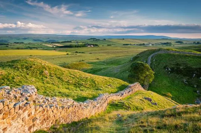
A significant portion of the wall still stands and can be followed on foot along the adjoining Hadrian's Wall Path. The largest Roman archaeological feature anywhere, it runs a total of 73 miles (117.5 kilometres) in northern England.[3] Regarded as a British cultural icon, Hadrian's Wall is one of Britain's major ancient tourist attractions.[4] It was designated as a UNESCO World Heritage Sitein 1987.[5] In comparison, the Antonine wall, thought by some to be based on Hadrian's wall (the Gillam hypothesis),[6] was not declared a World Heritage site until 2008.[7
It is a common misconception that Hadrian's Wall marks the boundary between England and Scotland. In fact Hadrian's Wall lies entirely within England and has never formed the Anglo-Scottish border.[9] While it is less than 0.6 mi (1.0 km) south of the border with Scotland in the west at Bowness-on-Solway, in the east it is as much as 68 miles (109 km) away.
Hadrian's Wall was probably planned before Hadrian's visit to Britain in AD 122. According to restored sandstone fragments found in Jarrow which date from 118 or 119, it was Hadrian's wish to keep "intact the empire", which had been imposed on him via "divine instruction".[13]
Although Hadrian's biographer wrote "[Hadrian] was the first to build a wall 80 miles long to separate the Romans from the barbarians", reasons for the construction of the wall vary, and no recording of an exact explanation survives.[14] Theories have been presented by historians, mostly of an expression of Roman power and Hadrian's policy of defence before expansion. On his accession to the throne in 117, there was unrest and rebellion in Roman Britain and from the peoples of various conquered lands across the Empire, including Egypt, Judea, Libya and Mauritania.[13]
These troubles may have influenced Hadrian's plan to construct the wall as well as his construction of limites in other areas of the Empire, but to what extent is unknown. Scholars disagree over how much of a threat the inhabitants of northern Britain really presented and whether there was any economic advantage in defending and garrisoning a fixed line of defences like the Wall, rather than conquering and annexing what has become the Scottish Lowlands and defending the territory with a loose arrangement of forts.[13]
The limites of Rome were never expected to stop tribes from migrating or armies from invading, and while a frontier protected by a palisade or stone wall would help curb cattle-raiders and the incursions of other small groups,[15] the economic viability of constructing and keeping guarded a wall 72 miles (116 km) long along a sparsely populated border to stop small-scale raiding is dubious.[13]
Another possible explanation for the wall is the degree of control it would have provided over immigration, smuggling and customs.[13]Limites did not strictly mark the boundaries of the empire: Roman power and influence often extended...
Read more