One of the best national parks in North America. It is know as Mount McKinley.
The following are info from Denali National park and preserve website:
The Basics of Planning a Denali Visit:
•Where you can go by car Denali National Park and Preserve has just one road, called the Denali Park Road, and it is the main avenue for visitors to see and experience Denali.
The road is 92 miles long, and only the first 15 miles of it are paved. That paved portion, leading from the park entrance to Savage River, is open during the summer for public (non-commercial) vehicles to drive.
Getting to the park is fairly easy, as there is only one highway (Alaska State Route 3, also called the "George Parks Highway"), connecting Anchorage—Denali—Fairbanks.
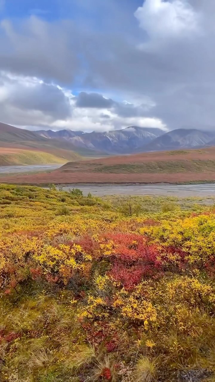
•When to visit The summer season in Denali is May 20—mid-September. Travel beyond mile 15 is limited to buses (or under human power, hiking, biking, etc). Please note that some children will require car seats on the park buses. Learn more about bus trips in Denali.
Visitors coming in spring or fall (so, before May 20 or after the second full week of September) should prepare for the unexpected. It can snow heavily almost any month of the year, so the road in spring or fall may be open or closed depending on conditions.
•Popular Things to Do
In 1917, Congress created this park for one main reason: to protect Dall sheep. Over time, Congress expanded the park boundaries and added other reasons for its existence, including protection of North America's tallest mountain (also called Denali) and to provide a place for wilderness recreation. Hiking (on and off trail) Denali is a huge park ( 6 million acres), but has very few trails. This is intentional; as mentioned above, one reason this park exists is to preserve wilderness recreation, which includes hiking and backpacking in a trail-less landscape. Some marked trails exist, mainly around the two visitor centers. Looking for Wildlife Most Denali visitors say they came for the scenery and/or wildlife. In either case, the best way to sightsee is by...
Read moreDenali (/dɪˈnɑːli/) (also known as Mount McKinley, its former official name) is the highest mountain peak in North America, with a summit elevation of 20,310 feet (6,190 m) above sea level. With a topographic prominence of 20,156 feet (6,144 m) and a topographic isolation of 4,629 miles (7,450 km), Denali is the third most prominent and third most isolated peak on Earth, after Mount Everest and Aconcagua. Located in the Alaska Range in the interior of the U.S. state of Alaska, Denali is the centerpiece of Denali National Park and Preserve. The Koyukon people who inhabit the area around the mountain have referred to the peak as "Denali" for centuries. In 1896, a gold prospector named it "Mount McKinley" in support of then-presidential candidate William McKinley; that name was the official name recognized by the Federal government of the United States from 1917 until 2015. In August 2015, following the 1975 lead of the State of Alaska, the United States Department of the Interior announced the change of the official name of the mountain to Denali.
In 1903, James Wickersham recorded the first attempt at climbing Denali, which was unsuccessful. In 1906, Frederick Cook claimed the first ascent, but this ascent is unverified and its legitimacy questioned. The first verifiable ascent to Denali's summit was achieved on June 7, 1913, by climbers Hudson Stuck, Harry Karstens, Walter Harper, and Robert Tatum, who went by the South Summit. In 1951, Bradford Washburn pioneered the West Buttress route, considered to be the safest and easiest route, and therefore the most popular currently in use. On September 2, 2015, the U.S. Geological Survey announced that the mountain is 20,310 feet (6,190 m) high, not 20,320 feet (6,194 m), as measured in 1952...
Read moreألاسكا هي أكبر الولايات المتحدة من حيث المساحة ، حيث تبلغ 1,481.346 كيلومتر مربع ، و تقع ولاية ألاسكا بالقرب من روسيا و في نطاق الأراضي الكندية ، في الركن الشمالي الغربي لقارة أمريكا الشمالية ، تحدها من الجهة الشرقية المقاطعتين الكنديتين يوكون و كولومبيا البريطانية ، و يحدها من الجهة الغربية بحر بيرنغ ، و مضيق بيرنغ ، و بحر تشوكنشي . أما من الجنوب فيحدها المحيط الهادي و خليج ألاسكا ، و من الشمل المحيط المتجمد الشمالي و بحر بوفورت من أهم الولايات الإستراتيجية وتشتهر هذه الولاية بصيد الأسماك والفراء وأكواخ الإسكيمو الثلجية المعروفة باسم الايجلو Igloo. واسم الشهرة لهذه الولاية هو أرض شمس منتصف الليل Land of the Midnight Sun بينما يعود اسم آلاسكا إلى لغة سكان جزر الالوتيان Aleutian بمعنى الأراضي العظيمة أو الأراضي التي تصطدم بالبحر. وجد عدد قليل من المسلمين بولاية ألاسكا، ومن أهم المساجد في آلاسكا مسجد الرشيد في مدينة انكوراج والمركز الإسلامي في نفس المدينة. المعالم السياحية في آلاسكا .حدائق دينالي العامة Denali National Park . نهر مندنهال الجليدي Mendenhall في شمال غابات تونجس Tongass . حدائق كاتامي العامة Katami National Park والتي تحتوي على وادي العشرة آلاف أدخنة Valley of Ten Thousand Smokes وهى منطقة معروفة بالنشاط البركاني. عاصمة آلاسكا جونو Juneau ، وقد تم تقسيم آلاسكا سنة 1912 وانضمت إلى الولايات المتحدة الأمريكية في 3 يناير سنة 1959 وأصبح ترتيبها الولاية رقم 49 لقد تم التصديق على دستور الولاية في 24 إبريل سنة 1956 . أهم المدن الكبيرة في آلاسكا مدينة انكوراج وتعداد سكانها 270.951 نسمة . مدينة فيربنكس Fairbanks 30.970 نسمة. مدينة استيكا Sitka 8.876 نسمة. وتضم آلاسكا 27 مقاطعة. جغرافية الآسكا تبلغ مساحة آلاسكا 1.481.353 كم مربع، وتعتبر آلاسكا من أكبر الولايات الأمريكية وتقع في أقصى الجزء الشمالي الغربي لقارة أمريكا الشمالية يفصلها غرب كندا عن بقية الولايات المتحدة المؤتلفة، يحدها من الشمال المحيط القطبي وبحر بيفورتBeaufort Sea وجنوبا” خليج آلاسكا والمحيط الهادي، ويحدها شرقا” كولومبيا البريطانية وأراضي يوكن Yukon وغربا” بحر بيرنج Bering Sea ومضيق بيرنج وبحر الشوكاتشي Chukchi Sea . وتمثل ولاية آلاسكا خمس مساحة الولايات المتحدة الأمريكية تقريبا” وهى على طرف شبه جزيرة سيوارد Seward وكلاهما يبعد أميالا” قليلة عن الشرق الأقصى الروسي. وتعد شبه جزيرة سيوارد سهلا” أجردا” مما يجعل كثافتها السكانية ضئيلة جدا”. وتمتد ولاية آلاسكا جنوبا” نحو روسيا في كل من منطقة شبه جزيرة آلاسكا وجزر ألوتيان Aleutian Island حيث تبعد حوالي 109كم عن جزر كاماندروسكي Komandorski وكلاهما يفصل بحر بيرنج عن المحيط الهادي. ومنطقة شبه جزيرة آلاسكا تغطيها الحشائش بصفة دائمة ولكنها خالية من الأشجار والمناخ هناك شديد القسوة حيث الضباب والصقيع في الشتاء والعواصف العنيفة وتحظى جزر الالوتيان بأهمية إستراتيجية كما أنها تحتوي على عدة براكين نشطة. ومن ناحية أخرى فإن الجزء الأوسط من ولاية آلاسكا يغلب عليه طقس شديد البرودة في الشتاء وصيف قصير حار. وفي شمال سلسلة جبال بروكس Brooks Range حيث تقع آلاسكا القطبية تتراوح درجات الحرارة في الشتاء من سالب 23 سليزيوس إلى سالب 40 سليزيوس والأراضي هناك جدباء يقطعها بعض الأنهار القصيرة ونهر واحد طويل الكولفيل Colville River . من أهم الأنهار في ولاية آلاسكا نهر يوكن Yukon الذي يقطع الولاية من غربها إلى شرقها ممتدا” بطول 1,931 كم من الحدود الكندية وحتى بحر بيرنج. سكان آلاسكا يبلغ عدد سكان آلاسكا حوالي 655,435 ألف نسمة حسب إحصائيات سنة 2004. وتبلغ نسبة البيض من أصول أوروبية 69.3% والأمريكيون الأفارقة 3.5% والهنود الحمر والسكان الأصليون 15.6% والأجناس الأخرى 1.6% والأجناس المختلطة 5.4% وذوى الأصول اللاتينية 4.1% وذلك طبقا” لإحصائيات سنة 2000. وتبلغ نسبة من يملكون مساكنهم 67.2% حسب إحصائيات 2003 أما بالنسبة للسكان الذين يعانون من الفقر هي 14.7% حسب إحصائيات سنة 2003 وتبلغ نسبة البطالة 6.4% حسب إحصائيات عام 2005 . اقتصاد آلاسكا يبلغ الإنتاج الإجمالي لولاية آلاسكا 38,5 GSP مليار دولار، ويبلغ متوسط دخل الفرد سنويا” 34.654 ألف دولار وذلك طبقا” لإحصائيات عام 2004. .نسبة البطالة وصلت إلى 6.4% عام 2005. .يبلغ إنتاج قطاع الصناعة 678 مليون دولار. .يبلغ إنتاج القطاع الحكومي 6.268 مليون دولار. .يبلغ إنتاج التأمين والصحة 1.119 مليون دولار. .يبلغ إنتاج الخدمات الأخرى 1.7 مليون دولار. وذلك طبقا” لإحصائيات عام 2003. وتعتبر آلاسكا هى الولاية الأخيرة من حيث إنتاج المحاصيل الزراعية وتعتبر منطقة جنوب آلاسكا هي أفضل منطقة صالحة للزراعة وذلك في وادي ماتاناسوكا Matanuska وتعتبر النباتات الصوبات الزجاجية والألبان والبطاطس على رأس قائمة المنتجات...
Read more