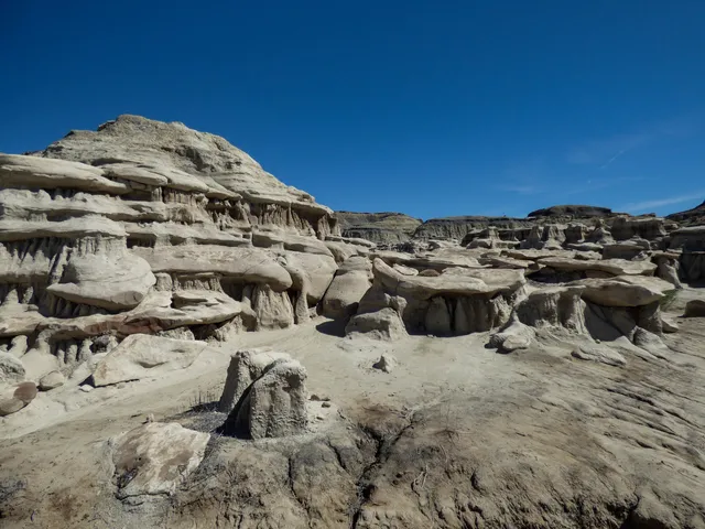
If you’re unfamiliar with the area but an avid hiker, Bisti Badlands is an amazing area to check out on your own, so long as you’ve come prepared with GPS coordinates, maps, and parking advice. I have no affiliation with it, but we used Firefall Photography’s website for excellent resources on all of that, including pinpoints for the north/south parking areas. As experienced hikers (Grand Canyon, Utah parks, Himalayas, etc.), we know our limitations, including the fact that our GPS apps often make quirky jumps in extremely remote areas, so we tried to pick and choose our priorities, ultimately deciding that we could manage the Bisti portion by ourselves. (We did the De-Na-Zin side the following day, with a guide. We had limited time to explore and didn’t want to waste it false-navigating to permitted parking sites or major landmarks on our own, especially in monsoon season, so we signed up for the Ah-Shi-Sle-Pah tour offered by Navajo Wilderness Adventures for that area — absolutely wonderful!) On our independent day at Bisti, we arrived around 3 p.m., and a few sprinkles started just after 7 p.m., cutting off our desire to stay into the golden/blue hours, but it’s worth visiting no matter the time of day. Since we had only one sunrise moment to spend there, we decided to end at Wings, despite having read that the Eggs don’t photograph well in brighter light, and we were pleased with that choice in the end, since we had “near sunset” at the gorgeous hill of wings. Overall, in just under five hours, we made it from the Eggs to the Wings and hit nearly every major formation in between, including the Rock Garden, petrified wood, Hoodoo City, Vanilla Hoodoos, Manta Ray, and more. We found that some of our GPS points didn’t quite match the Firefall map (including at the Beige Hoodoos and Manta Ray), but going armed with general AllTrails locations, Firefall and AllTrails maps, Gaia, and a tiny print map with photos made it all come together, allowing us plenty of time to photograph the landscape from vantages up, down, and all around. The relatively flat terrain made our nine miles of hiking relatively simple (but do avoid it after rain where possible), and it was a fantastic journey — such mesmerizing formations and...
Read more