HTML SitemapExplore
logo
Find Things to DoFind The Best Restaurants

Devil's Kettle — Attraction in East Cook

Name
Devil's Kettle
Description
Nearby attractions
Nearby restaurants
Nearby hotels
Related posts
Keywords
Devil's Kettle tourism.Devil's Kettle hotels.Devil's Kettle bed and breakfast. flights to Devil's Kettle.Devil's Kettle attractions.Devil's Kettle restaurants.Devil's Kettle travel.Devil's Kettle travel guide.Devil's Kettle travel blog.Devil's Kettle pictures.Devil's Kettle photos.Devil's Kettle travel tips.Devil's Kettle maps.Devil's Kettle things to do.
Devil's Kettle things to do, attractions, restaurants, events info and trip planning
Devil's Kettle
United StatesMinnesotaEast CookDevil's Kettle

Basic Info

Devil's Kettle

Hovland, MN 55606
4.8(335)
Open 24 hours
Save
spot

Ratings & Description

Info

Outdoor
Adventure
Scenic
Family friendly
Pet friendly
Off the beaten path
attractions: , restaurants:
logoLearn more insights from Wanderboat AI.
Website
dnr.state.mn.us

Plan your stay

hotel
Pet-friendly Hotels in East Cook
Find a cozy hotel nearby and make it a full experience.
hotel
Affordable Hotels in East Cook
Find a cozy hotel nearby and make it a full experience.
hotel
The Coolest Hotels You Haven't Heard Of (Yet)
Find a cozy hotel nearby and make it a full experience.
hotel
Trending Stays Worth the Hype in East Cook
Find a cozy hotel nearby and make it a full experience.

Reviews

Get the Appoverlay
Get the AppOne tap to find yournext favorite spots!
Wanderboat LogoWanderboat

Your everyday Al companion for getaway ideas

CompanyAbout Us
InformationAI Trip PlannerSitemap
SocialXInstagramTiktokLinkedin
LegalTerms of ServicePrivacy Policy

Get the app

© 2025 Wanderboat. All rights reserved.
logo

Posts

Ronda TuttRonda Tutt
FYI Do not follow this peg to location on google maps for just Devils Kettle . To access this fall you have to go through State Park Judge Magney. It’s a mile hike, you will see upper falls first and then 700 ft more going further up you will be able to see the Devils Kettle. It’s absolutely beautiful. Just past the platform where you can take pictures you will see the flattening of the river and walk over down stream a little and put your feet in the water or get in all the way, trust me it felt good to cool off after that long hike. Warning the hike to these falls is a good packed down path, however you are constantly going up hill until you reach stairs and then it’s 175 steps down, once down you’ll see another set of steps, about 6 steps that leads to rock platform to see upper falls, right at the small step of steps you will see a sign with arrow stating Devils Kettle 700ft upward. Depending on good of shape you are in will depend on how fast you can walk a mile in a up hill terrain. Just take some water with you, you’re going to get a good workout. Well worth the hike.
Bryan HanselBryan Hansel
Devil's Kettle Falls splits in two and one side goes down a hole and disappears. Nobody knows where that water comes out, but it is suspected to come out downstream as the river doesn't lose volume. The hike is an easy to moderate hike on a good trail with some elevation gain. The hardest part is a set of steps leading down to Upper Falls and then to Devil's Kettle. WARNING: Don't fall for the Google Map route. The trail that it shows does not exist! You have to park in Judge CR Magney State Park and then hike up the Superior Hiking Trail to get to the falls. You can hike down the Superior Hiking Trail from the Camp 20 Road, but it is a 3.6-mile hike vs. a 0.9-mile hike. Just to repeat, the "trail" shown on the Google Map route DOES NOT EXIST! I'm posting this as someone who lives in the county just to warn you, because so many people get lost trying to find this nonexistent trail.
Keith WegnerKeith Wegner
This is a must see if you’re in the area! Let me the first to warn you this is a long and treacherous hike. It will take you at least an hour. I classify the difficulty of this hike as medium-high. Make sure that you bring water and don’t forget to rest. There are outhouse type toilets in the beginning of the trailhead. Next to them you will find water spouts. Also, there are many sections to this hike from hills to steps, if you have a baby or toddler I do not recommend bringing a stroller. We brought ours back to the car and took turns carrying our grandson. There are breath taking views and after the beginning you will find a good trout fishing spot at the lower falls. This is also a good swimming spot as well. Don’t worry about getting lost, these trails are highly traveled and you will also see signs at intersections.
See more posts
See more posts
hotel
Find your stay

Pet-friendly Hotels in East Cook

Find a cozy hotel nearby and make it a full experience.

FYI Do not follow this peg to location on google maps for just Devils Kettle . To access this fall you have to go through State Park Judge Magney. It’s a mile hike, you will see upper falls first and then 700 ft more going further up you will be able to see the Devils Kettle. It’s absolutely beautiful. Just past the platform where you can take pictures you will see the flattening of the river and walk over down stream a little and put your feet in the water or get in all the way, trust me it felt good to cool off after that long hike. Warning the hike to these falls is a good packed down path, however you are constantly going up hill until you reach stairs and then it’s 175 steps down, once down you’ll see another set of steps, about 6 steps that leads to rock platform to see upper falls, right at the small step of steps you will see a sign with arrow stating Devils Kettle 700ft upward. Depending on good of shape you are in will depend on how fast you can walk a mile in a up hill terrain. Just take some water with you, you’re going to get a good workout. Well worth the hike.
Ronda Tutt

Ronda Tutt

hotel
Find your stay

Affordable Hotels in East Cook

Find a cozy hotel nearby and make it a full experience.

Get the Appoverlay
Get the AppOne tap to find yournext favorite spots!
Devil's Kettle Falls splits in two and one side goes down a hole and disappears. Nobody knows where that water comes out, but it is suspected to come out downstream as the river doesn't lose volume. The hike is an easy to moderate hike on a good trail with some elevation gain. The hardest part is a set of steps leading down to Upper Falls and then to Devil's Kettle. WARNING: Don't fall for the Google Map route. The trail that it shows does not exist! You have to park in Judge CR Magney State Park and then hike up the Superior Hiking Trail to get to the falls. You can hike down the Superior Hiking Trail from the Camp 20 Road, but it is a 3.6-mile hike vs. a 0.9-mile hike. Just to repeat, the "trail" shown on the Google Map route DOES NOT EXIST! I'm posting this as someone who lives in the county just to warn you, because so many people get lost trying to find this nonexistent trail.
Bryan Hansel

Bryan Hansel

hotel
Find your stay

The Coolest Hotels You Haven't Heard Of (Yet)

Find a cozy hotel nearby and make it a full experience.

hotel
Find your stay

Trending Stays Worth the Hype in East Cook

Find a cozy hotel nearby and make it a full experience.

This is a must see if you’re in the area! Let me the first to warn you this is a long and treacherous hike. It will take you at least an hour. I classify the difficulty of this hike as medium-high. Make sure that you bring water and don’t forget to rest. There are outhouse type toilets in the beginning of the trailhead. Next to them you will find water spouts. Also, there are many sections to this hike from hills to steps, if you have a baby or toddler I do not recommend bringing a stroller. We brought ours back to the car and took turns carrying our grandson. There are breath taking views and after the beginning you will find a good trout fishing spot at the lower falls. This is also a good swimming spot as well. Don’t worry about getting lost, these trails are highly traveled and you will also see signs at intersections.
Keith Wegner

Keith Wegner

See more posts
See more posts

Reviews of Devil's Kettle

4.8
(335)
avatar
5.0
4y

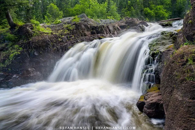
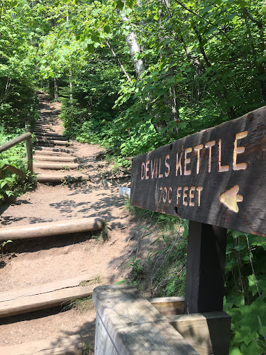
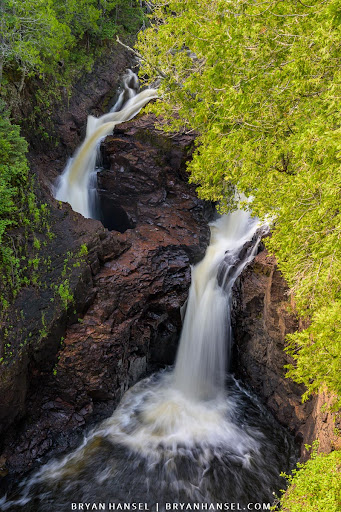
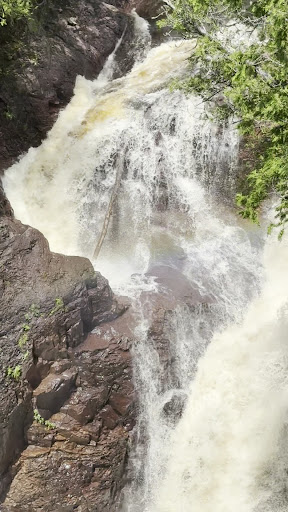
Judge C. R. Magney State Park is located on scenic Minnesota State Highway 61, 25 miles (40 km) from the Canada–United States border.3] The last 8 miles (13 km) of the Brule River flow through the park, dropping 800 feet (240 m) and producing several waterfalls and cascades.[4] A tributary of the Brule, Gauthier Creek, flows in from the west. Mons Creek, an intermittent stream on the park's northeast border, drains a small marsh.[4] This stretch of the Brule River has three named waterfalls. 1 mile (1.6 km) from the lakeshore, Lower Falls drops 7 feet (2.1 m) over two steps just before the mouth of Gauthier Creek.[5 A short distance upstream are Upper Falls, dropping 25 feet (7.6 m), and Devil's Kettle Falls.5] From the Devil's Kettle to Upper Falls the river flows through a .25-mile (0.40 km) rocky gorge, as does the last .5 miles (0.80 km) of Gauthier Creek.[3:56 Developed areas and trail access are confined to the lower third of the park.[7]:54 The northern section is rugged and difficult to access, with open ridges stepping away from the river valley.[8] These extremes produce an elevation change of about 1,000 feet (300 m) in the park. The state park is entirely within Grand Portage State Forest, although most of the land directly adjacent to the park is privately owned inholdings.[9] The park has a continental climate of extreme seasonal variation, moderated by Lake Superior, which keeps the shore areas 6 to 8 degrees warmer in winter and cooler in summer than the inland part of the region.[4] Thus winters tend to be mild...

   Read more
avatar
5.0
6y

FYI Do not follow this peg to location on google maps for just Devils Kettle . To access this fall you have to go through State Park Judge Magney. It’s a mile hike, you will see upper falls first and then 700 ft more going further up you will be able to see the Devils Kettle. It’s absolutely beautiful. Just past the platform where you can take pictures you will see the flattening of the river and walk over down stream a little and put your feet in the water or get in all the way, trust me it felt good to cool off after that long hike. Warning the hike to these falls is a good packed down path, however you are constantly going up hill until you reach stairs and then it’s 175 steps down, once down you’ll see another set of steps, about 6 steps that leads to rock platform to see upper falls, right at the small step of steps you will see a sign with arrow stating Devils Kettle 700ft upward. Depending on good of shape you are in will depend on how fast you can walk a mile in a up hill terrain. Just take some water with you, you’re going to get a good workout. Well...

   Read more
avatar
5.0
4y

Devil's Kettle Falls splits in two and one side goes down a hole and disappears. Nobody knows where that water comes out, but it is suspected to come out downstream as the river doesn't lose volume. The hike is an easy to moderate hike on a good trail with some elevation gain. The hardest part is a set of steps leading down to Upper Falls and then to Devil's Kettle.

WARNING: Don't fall for the Google Map route. The trail that it shows does not exist! You have to park in Judge CR Magney State Park and then hike up the Superior Hiking Trail to get to the falls. You can hike down the Superior Hiking Trail from the Camp 20 Road, but it is a 3.6-mile hike vs. a 0.9-mile hike. Just to repeat, the "trail" shown on the Google Map route DOES NOT EXIST! I'm posting this as someone who lives in the county just to warn you, because so many people get lost trying to find this...

   Read more
Page 1 of 7
Previous
Next