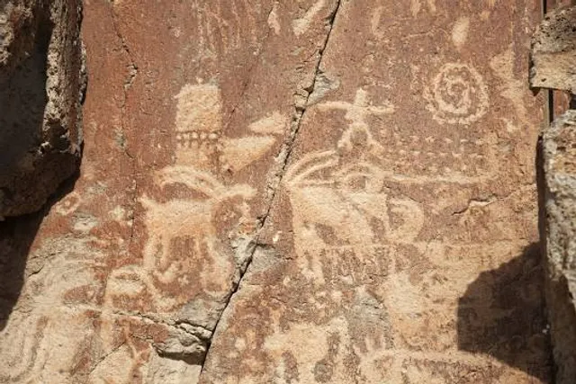
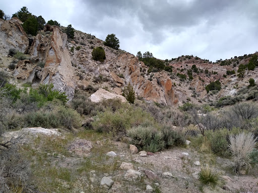
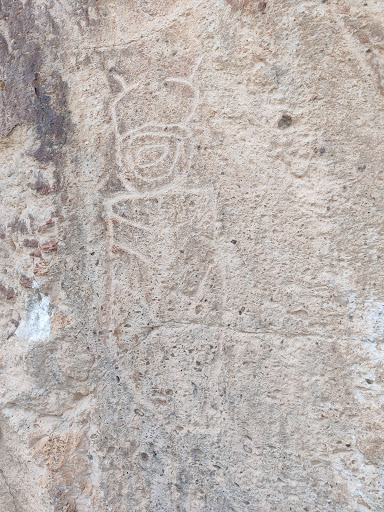
I hiked the Paiute trail 0-1 which is just east of the park about 1/4 mile or so past the Sam Stowe campground on Clear Creek Canyon Rd. It's a multi-purpose trail that's got signage for OHV vehicles (50 inch max ATV width with a fenced-opening to prevent wider vehicles from entering - see photo below) but was told that you can horseback ride and hike on there as well. Due to the trail being so wide and worn in by all the ATV traffic, it would be virtually impossible to get lost as there was no confusion as to the correct path whereas in many other trails I've encountered, continuity of direction becomes obscured by vegetation overgrowth.
Because it's an ATV trail primarily, it's wide enough for 2 people to hike side by side rather than one behind the other. But a word of caution the trail is littered with rocks big enough to trip you up and the surface is soft and coming down, traction was loose and treacherous at points and if you're not watching where you're going in both directions, you can easily trip or roll an ankle. I actually fell once and had several other near stumbles.
THIS WAS THEE HARDEST HIKE I'VE EVER DONE and it wasn't even close! Fortunately the temperature was unseasonably cool for late May in the 40's otherwise if it would have been your typical late spring temps in the mid 70's, it would have been even tougher.
WARNING: IF YOU ARE NOT TRAIL FIT NOR ALTITUDE ACCLIMATED, SLOW DOWN AND PACE YOURSELF AND DON'T HIKE AS LONG AS YOU NORMALLY WOULD OR YOU WILL EXPERIENCE EXTREME FATIGUE!!!
HOWEVER, IF YOU ARE THE HUMAN EQUIVALENT OF A MOUNTAIN GOAT, CHALLENGE YOURSELF AND GO FOR IT!!!
Remember you're starting altitude is around 5700 feet and by the time I turned around I was over 7,500 feet and that will affect your breathing so keep that in mind not to mention the mountain is fairly steep the entire way up.....it is very taxing. Typically trails that go up a mountain are a series of switchbacks to greatly reduce the slope but this route is straight up the mountain.
Make sure to dress in layers due to the temperature increases about 3.5 to 5.5 degrees Fahrenheit for every 1000 feet of elevation gain. It was definitely cooler and windier near the end of my ascent.
It's an out and back trail and I covered 6.7 miles and I never got to the peak of the mountain as it was straight uphill for over 3 -1/3 miles and it was still going up when I decided to stop and turn around because both my legs and my lungs had been greatly challenged. Coming down the mountain was not a strain on the cardiovascular system but the strain on the legs and feet continued to accumulate.
There are great vistas to view the surrounding topography but those views are few so take advantage of those when you can and take your photos or just admire the view because a lot of the trees obscure your vision of the beauty that surrounds you.
There's no shade on the trail as the trees are not tall enough or close enough to block the sun. So either slather on sunscreen or wear pants instead of shorts, long sleeve shirts instead of short sleeves and a wide-brimmed hat otherwise you may get sunburned.
Also if you need to take a break there is the rare boulder big enough or deadfall log to sit on so take advantage of those when you see them otherwise you'll be taking your pit stop sitting on the ground and that may not be as comfortable or restful!
There was no one else on the trail the entire nearly 4 hours that I was on it so it was serenely quiet and there was no trash anywhere nor was there any horse...
Read more