HTML SitemapExplore
logo
Find Things to DoFind The Best Restaurants

Willis Creek Slot Canyon trailhead — Attraction in Four Corners States

Name
Willis Creek Slot Canyon trailhead
Description
Nearby attractions
Nearby restaurants
Nearby hotels
Related posts
Keywords
Willis Creek Slot Canyon trailhead tourism.Willis Creek Slot Canyon trailhead hotels.Willis Creek Slot Canyon trailhead bed and breakfast. flights to Willis Creek Slot Canyon trailhead.Willis Creek Slot Canyon trailhead attractions.Willis Creek Slot Canyon trailhead restaurants.Willis Creek Slot Canyon trailhead travel.Willis Creek Slot Canyon trailhead travel guide.Willis Creek Slot Canyon trailhead travel blog.Willis Creek Slot Canyon trailhead pictures.Willis Creek Slot Canyon trailhead photos.Willis Creek Slot Canyon trailhead travel tips.Willis Creek Slot Canyon trailhead maps.Willis Creek Slot Canyon trailhead things to do.
Willis Creek Slot Canyon trailhead things to do, attractions, restaurants, events info and trip planning
Willis Creek Slot Canyon trailhead
United StatesUtahFour Corners StatesWillis Creek Slot Canyon trailhead

Basic Info

Willis Creek Slot Canyon trailhead

Kanab, UT 84741
4.8(213)
Open until 12:00 AM
Save
spot

Ratings & Description

Info

Outdoor
Adventure
Scenic
Family friendly
Pet friendly
attractions: , restaurants:
logoLearn more insights from Wanderboat AI.
Open hoursSee all hours
WedOpen 24 hoursOpen

Plan your stay

hotel
Pet-friendly Hotels in Four Corners States
Find a cozy hotel nearby and make it a full experience.
hotel
Affordable Hotels in Four Corners States
Find a cozy hotel nearby and make it a full experience.
hotel
The Coolest Hotels You Haven't Heard Of (Yet)
Find a cozy hotel nearby and make it a full experience.
hotel
Trending Stays Worth the Hype in Four Corners States
Find a cozy hotel nearby and make it a full experience.

Reviews

Things to do nearby

From Las Vegas: Bryce Canyon & Zion National Parks Day Tour with Lunch
Wed, Dec 10 • 5:15 AM
Utah, 84764
View details
Get the Appoverlay
Get the AppOne tap to find yournext favorite spots!
Wanderboat LogoWanderboat

Your everyday Al companion for getaway ideas

CompanyAbout Us
InformationAI Trip PlannerSitemap
SocialXInstagramTiktokLinkedin
LegalTerms of ServicePrivacy Policy

Get the app

© 2025 Wanderboat. All rights reserved.
logo

Posts

Your browser does not support the video tag.
explore.hike.teachexplore.hike.teach
Eight Water Hikes to keep you cool in Southern Utah’s summer season 💧Zion Narrows - mileage varies. 2-17 miles green waters and soaring canyon walls. Most people take the shuttle and hike up the Virgin river and turn around when ready but if you secure a permit you can hike from the top down and camp overnight. 💧Pleasant Creek - slick rock chutes, cascades, tall slick rock walls. 7 miles RT 💧 Sulphur Creek - (no it doesn’t smell like sulphur)- 3 waterfalls, red rock slots. May require swimming. 6 mile hike requires shuttle. 💧 Paria Canyon - Most similar to the Zion’s Narrows, high solitude factor. Can do as a multi day through backpack trip or experience part of the canyon as a day trip out and back. 💧Willis Creek Slot- 3+ miles, family friendly. Can avoid the water. 💧Escalante river - Escalante Natural Bridge, Skyline Arch, Anasazi ruins and a Petroglyph panel. 6 miles RT or 15 mile through hike with shuttle. 💧Kanarraville Falls - permit required. 2 waterfalls, a natural water slide, and nontechnical slot canyon. 💧The Subway - permit required. Iconic. 9.6 miles out and back from bottom up or as a technical 9.5 mile top down hike. Remember all water hikes have an inherent risk of flash flooding. Know the weather and trail conditions and most importantly consult with a local ranger before you go. See link in bio for flash flood predictions by area. Which hike would you like to try first? Practice LNT (Leave No Trace) principles so everyone can enjoy for years to come. #southernutah #zionnarrows #zionnationalpark #waterhike #riverhike #nationalpark #hikingadventures #places_wow #findyourbackcountry #grandstaircaseescalante #kanab #idhikethat #capitolreefnationalpark #slotcanyon #utahhikes
Your browser does not support the video tag.
explore.hike.teachexplore.hike.teach
✨Days of outdoor adventure near Kanab, Utah ✨ [Save] Highlights to plan your visit: 🥾Wire Pass slot 3.4 miles- fee required pay at recreation.gov 💡Skylight Arch 2 miles -SUV or better required to get to the trailhead ⌛️Sand (Moqui) Caves .5 miles -easy scrambling required 🐚 The Nautilus 1 mile 🍄Todastool Hoodoos 1.8 miles ⚪️Cottonwood Narrows 2-3.7 miles (road impassable when wet) 🌳Lick Wash 2-4 miles (road impassable when wet) 💦Willis Creek Narrows 2.8 miles (road impassable when wet) 🌕White Pocket 1.2 miles -high clearance 4x4 required due to deep sand 🐉 Belly of the Dragon (tunnel) .5-1.8 miles Bonus: 🎰 Red Hollow Slot 2 miles (last clip) Pro tips: 🦮Dogs permitted 🚨Be sure to research current road conditions and trails as conditions can change for these trails and access roads. ‼️Please practice leave no trace when exploring outdoors. Pack out all your trash, TP and food scraps. Don’t mark up the rocks of trees, and respect others. Which trail are you choosing first? #kanab #utahhikes #utahunique #utahrocks #idhikethat #southernutah #hoodoos #adventureawaits #dogfriendly #familyfriendly #abrakanabra
Your browser does not support the video tag.
explore.hike.teachexplore.hike.teach
Seven water hike alternatives to the Zion’s Narrows to avoid the crowds. SAVE for later. 💧Pleasant Creek - slick rock chutes, cascades, aoaring sandstone walls, petroglyphs, a natural bridge, and a side slot7 miles RT 💧 Sulphur Creek - (no it doesn’t smell like sulphur)- 3 waterfalls, red rock narrows. natural wtaterslide 6 mile hike requires shuttle. 2nd Video clip in reel. 💧 Paria Canyon - Most similar to the Zion’s Narrows, high solitude factor. Can do as a multi day through backpack trip or experience part of the canyon as a day trip out and back. 💧Willis Creek - Slot- 3+ miles, family friendly. Can avoid the water. 💧Escalante river - Escalante Natural Bridge, Skyline Arch, Anasazi ruins and a Petroglyph panel. 6 miles RT or 15 mile through hike with shuttle. 💧Kanarra Falls - permit required. 2 waterfalls, a natural water slide, and nontechnical slot canyon. 💧The Subway - permit required. Iconic. 9 miles out and back from bottom up or as a technical 9 mile top down hike. Have you tried any of these? Which one do you want to hike first. Comment below. ⚠️Remember all water hikes have an inherent risk of flash flooding. Know the weather (flash flood predictions for Utah LINK IN BIO) and trail conditions and most importantly consult with a local ranger before you go. ⭐️Practice LNT (Leave No Trace) principles so everyone can enjoy for years to come. Pack out all trash and 💩 Don’t mark up or stack rocks Be respectful to wildlife and fellow hikers. #sheexplores #zionnationalpark #capitolreefnationalpark #zionnarrows #waterhikes #slotcanyons #southernutah #hikeutah #utahhiking #hikeon #hikingadventures #idhikethat
See more posts
See more posts
hotel
Find your stay

Pet-friendly Hotels in Four Corners States

Find a cozy hotel nearby and make it a full experience.

Eight Water Hikes to keep you cool in Southern Utah’s summer season 💧Zion Narrows - mileage varies. 2-17 miles green waters and soaring canyon walls. Most people take the shuttle and hike up the Virgin river and turn around when ready but if you secure a permit you can hike from the top down and camp overnight. 💧Pleasant Creek - slick rock chutes, cascades, tall slick rock walls. 7 miles RT 💧 Sulphur Creek - (no it doesn’t smell like sulphur)- 3 waterfalls, red rock slots. May require swimming. 6 mile hike requires shuttle. 💧 Paria Canyon - Most similar to the Zion’s Narrows, high solitude factor. Can do as a multi day through backpack trip or experience part of the canyon as a day trip out and back. 💧Willis Creek Slot- 3+ miles, family friendly. Can avoid the water. 💧Escalante river - Escalante Natural Bridge, Skyline Arch, Anasazi ruins and a Petroglyph panel. 6 miles RT or 15 mile through hike with shuttle. 💧Kanarraville Falls - permit required. 2 waterfalls, a natural water slide, and nontechnical slot canyon. 💧The Subway - permit required. Iconic. 9.6 miles out and back from bottom up or as a technical 9.5 mile top down hike. Remember all water hikes have an inherent risk of flash flooding. Know the weather and trail conditions and most importantly consult with a local ranger before you go. See link in bio for flash flood predictions by area. Which hike would you like to try first? Practice LNT (Leave No Trace) principles so everyone can enjoy for years to come. #southernutah #zionnarrows #zionnationalpark #waterhike #riverhike #nationalpark #hikingadventures #places_wow #findyourbackcountry #grandstaircaseescalante #kanab #idhikethat #capitolreefnationalpark #slotcanyon #utahhikes
explore.hike.teach

explore.hike.teach

hotel
Find your stay

Affordable Hotels in Four Corners States

Find a cozy hotel nearby and make it a full experience.

Get the Appoverlay
Get the AppOne tap to find yournext favorite spots!
✨Days of outdoor adventure near Kanab, Utah ✨ [Save] Highlights to plan your visit: 🥾Wire Pass slot 3.4 miles- fee required pay at recreation.gov 💡Skylight Arch 2 miles -SUV or better required to get to the trailhead ⌛️Sand (Moqui) Caves .5 miles -easy scrambling required 🐚 The Nautilus 1 mile 🍄Todastool Hoodoos 1.8 miles ⚪️Cottonwood Narrows 2-3.7 miles (road impassable when wet) 🌳Lick Wash 2-4 miles (road impassable when wet) 💦Willis Creek Narrows 2.8 miles (road impassable when wet) 🌕White Pocket 1.2 miles -high clearance 4x4 required due to deep sand 🐉 Belly of the Dragon (tunnel) .5-1.8 miles Bonus: 🎰 Red Hollow Slot 2 miles (last clip) Pro tips: 🦮Dogs permitted 🚨Be sure to research current road conditions and trails as conditions can change for these trails and access roads. ‼️Please practice leave no trace when exploring outdoors. Pack out all your trash, TP and food scraps. Don’t mark up the rocks of trees, and respect others. Which trail are you choosing first? #kanab #utahhikes #utahunique #utahrocks #idhikethat #southernutah #hoodoos #adventureawaits #dogfriendly #familyfriendly #abrakanabra
explore.hike.teach

explore.hike.teach

hotel
Find your stay

The Coolest Hotels You Haven't Heard Of (Yet)

Find a cozy hotel nearby and make it a full experience.

hotel
Find your stay

Trending Stays Worth the Hype in Four Corners States

Find a cozy hotel nearby and make it a full experience.

Seven water hike alternatives to the Zion’s Narrows to avoid the crowds. SAVE for later. 💧Pleasant Creek - slick rock chutes, cascades, aoaring sandstone walls, petroglyphs, a natural bridge, and a side slot7 miles RT 💧 Sulphur Creek - (no it doesn’t smell like sulphur)- 3 waterfalls, red rock narrows. natural wtaterslide 6 mile hike requires shuttle. 2nd Video clip in reel. 💧 Paria Canyon - Most similar to the Zion’s Narrows, high solitude factor. Can do as a multi day through backpack trip or experience part of the canyon as a day trip out and back. 💧Willis Creek - Slot- 3+ miles, family friendly. Can avoid the water. 💧Escalante river - Escalante Natural Bridge, Skyline Arch, Anasazi ruins and a Petroglyph panel. 6 miles RT or 15 mile through hike with shuttle. 💧Kanarra Falls - permit required. 2 waterfalls, a natural water slide, and nontechnical slot canyon. 💧The Subway - permit required. Iconic. 9 miles out and back from bottom up or as a technical 9 mile top down hike. Have you tried any of these? Which one do you want to hike first. Comment below. ⚠️Remember all water hikes have an inherent risk of flash flooding. Know the weather (flash flood predictions for Utah LINK IN BIO) and trail conditions and most importantly consult with a local ranger before you go. ⭐️Practice LNT (Leave No Trace) principles so everyone can enjoy for years to come. Pack out all trash and 💩 Don’t mark up or stack rocks Be respectful to wildlife and fellow hikers. #sheexplores #zionnationalpark #capitolreefnationalpark #zionnarrows #waterhikes #slotcanyons #southernutah #hikeutah #utahhiking #hikeon #hikingadventures #idhikethat
explore.hike.teach

explore.hike.teach

See more posts
See more posts

Reviews of Willis Creek Slot Canyon trailhead

4.8
(213)
avatar
5.0
2y

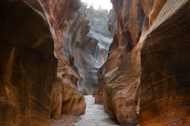
Wonderful series of beautiful slot canyons. They get better the further you go. Believe there were a total of five slot canyons. Once I completed the last slot canyon, turned around and enjoyed the slot canyons a second time. Was a amazingly beautiful hike.

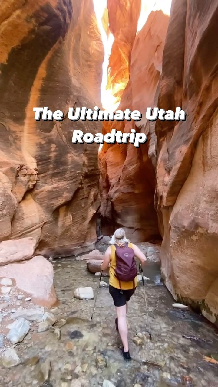
The hike is along a flat river bed. There are comments about the likelihood of getting your feet wet. I hiked in mid-July, and was able to jump or cross the steam stepping on rocks, so came out with relatively dry feet. However getting your feet wet would not be a problem.

There is a section about a mile in where there is a small waterfall. It appears the trail goes along a narrow ledge on the east side. However, there is a safer alternate rout on the west side. It's shaped like and upside down "V". Walk along a path heading up the hillside. Then at about 25-30 feet the path will then go downhill and take you to the creek bed again. There is a rock cairn were the trail reaches the creek bed. The rest of the hike an easy and wonderful. Each of the successive slot canyons had its own special character.

When I hiked it the July temperature was probably in the high 70/low 80s. Because your mostly in the shade, did not notice it. But would not do the hike if the temperature was very hot. Regardless, bring plenty of water. Initially were a lot of people, but after about a mile most people had turned around. After the first mile did not see another person until met a couple on my way back.

Now for the big issue. Driving Skutumpah Road to the trailhead. The road is a rutted and bumpy. There is some sand in some places, which may cause your car to slide a bit. The road is wide and reasonably maintained. However, there are some major hills. One in particular about a mile and a half from the start of the road, which is a bit of a challenge getting over.

A 4x4 or vehicle with a high suspension will not have a problem. I drove a Ford Ranger truck there with no major difficulty. Saw a sedan with not that high of a suspension make it. I do believe a sedan with a reasonably high suspension will make it, despite the ruts, bumps and rocks. Would not recommend the road for a vehicle with a new paint.

But despite the difficulty getting there, this is a great easy hike, and very...

   Read more
avatar
4.0
5y

This trail was so much fun!

Tl;DR: Dirt road to get there, nice intro to slot canyons, super flat and goes for a while. Would be a great one for kids to play along the way.

How to get there: the road is a dirt path for about 3 miles. It was freshly graded when we went so it wasn't bad at all. However we were definitely grateful we had a 4x4 suv for many of the parts. I don't think a 2 wheel drive could have made some of the climbs.

The parking: big parking lot, plenty of room for cars. There is a trail map and sign in book.

The trail: the info on the sign at the parking lot said the hike was 2.2 miles. If you keeping following Willis creek it can go much longer than that. The trail begins just across the road from the parking lot. You just follow the creek down so it's not difficult to find. Once on the trail it's amazing. Tons of variety from slot canyons to bigger open views and back to slots. There was not a lot of water when we went so we could easily avoid getting wet. I imagine that in the spring this would be much more difficult if not impossible with more water. There wasn't many people on the trail and it was so peaceful!

I'm sure there was and elevation drop during the hike with the water flowing downhill but it was so gradual that it felt flat the entire time so it wasn't strenuous at all.

For kids: kids would love this hike. From little caves to climb and hid in to the running water that you follow it is sure to have plenty for your little explorers! We can't wait to bring our kids.

The slot canyons were beautiful but not like some of the others options. This would be a great beginner hike or introduction to...

   Read more
avatar
5.0
1y

WOW, what a great experiance. Worth the uncomfortable drive along a dirt washboard road for sure. It's an easy BLM road to follow, but as always with a lot of slot canyon trails and anything where you have to drive over a dirt trail check the weather. Once there the trail is easily marked and you literaly walk straight into the slot caynyon, the stream can be fast our slow depending on the weather, when we where there we didn't need water shoes and could easily step and jump over the water when we had to o. The total length of the trail is 3 miles if I remember correctly, yet the slot canyon kinda ends when you get to a large rock. You could turn around here and not feel like you would have missed anything. The slot canyons are the gem on this trail, think narrrows in Zion but smaller, still great photo chances for sure. The water looks clear and clean, but just be aware this water goes through cattle land, we saw some people standing under one of the small water falls. If you do decide to do this close your mouth....LOL Plan around 2 hours for the hike and that included lots of phototaking and about 20 mins to drive along...

   Read more
Page 1 of 7
Previous
Next