HTML SitemapExplore
logo
Find Things to DoFind The Best Restaurants

Blodgett Trailhead — Attraction in Hamilton

Name
Blodgett Trailhead
Description
Nearby attractions
Nearby restaurants
Nearby hotels
Related posts
Keywords
Blodgett Trailhead tourism.Blodgett Trailhead hotels.Blodgett Trailhead bed and breakfast. flights to Blodgett Trailhead.Blodgett Trailhead attractions.Blodgett Trailhead restaurants.Blodgett Trailhead travel.Blodgett Trailhead travel guide.Blodgett Trailhead travel blog.Blodgett Trailhead pictures.Blodgett Trailhead photos.Blodgett Trailhead travel tips.Blodgett Trailhead maps.Blodgett Trailhead things to do.
Blodgett Trailhead things to do, attractions, restaurants, events info and trip planning
Blodgett Trailhead
United StatesMontanaHamiltonBlodgett Trailhead

Basic Info

Blodgett Trailhead

Blodgett Camp Rd, Hamilton, MT 59840
4.8(99)
Open 24 hours
Save
spot

Ratings & Description

Info

Outdoor
Adventure
Scenic
Pet friendly
Family friendly
Off the beaten path
attractions: , restaurants:
logoLearn more insights from Wanderboat AI.
Website
fs.usda.gov

Plan your stay

hotel
Pet-friendly Hotels in Hamilton
Find a cozy hotel nearby and make it a full experience.
hotel
Affordable Hotels in Hamilton
Find a cozy hotel nearby and make it a full experience.
hotel
The Coolest Hotels You Haven't Heard Of (Yet)
Find a cozy hotel nearby and make it a full experience.
hotel
Trending Stays Worth the Hype in Hamilton
Find a cozy hotel nearby and make it a full experience.

Reviews

Things to do nearby

Adventurous Scavenger Hunt! - Stevensville Spectacular Scavenge
Wed, Dec 10 • 7:00 AM
315 Charlos Street, Stevensville, MT 59870
View details
Amazing Scavenger Hunt! - Hamilton Fun Jam
Wed, Dec 10 • 7:00 AM
173 South 3rd Street, Hamilton, MT 59840
View details
Get the Appoverlay
Get the AppOne tap to find yournext favorite spots!
Wanderboat LogoWanderboat

Your everyday Al companion for getaway ideas

CompanyAbout Us
InformationAI Trip PlannerSitemap
SocialXInstagramTiktokLinkedin
LegalTerms of ServicePrivacy Policy

Get the app

© 2025 Wanderboat. All rights reserved.
logo

Reviews of Blodgett Trailhead

4.8
(99)
avatar
5.0
5y

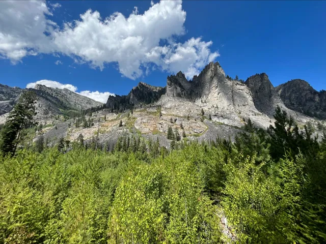
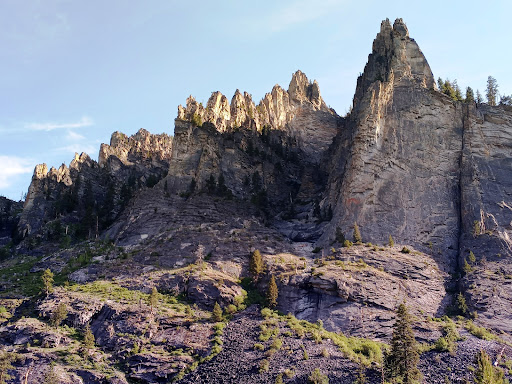
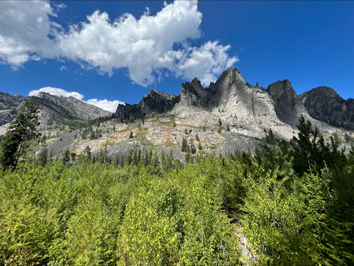
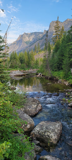
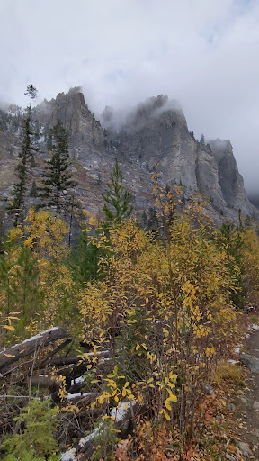
The beautys of Blodgett are unsurpassed, big leaf bright red 'thimble berries line the sides of the wet soggy parts of the trail before getting to still waters 1 & 2 with 3 a bit farther as you angle up high along the canyons south side over the 1st of many rock slides, you also notice the higher you side climb that the creek has disappeared under the huge scattered rock slide, you can feel the rocks vibrate before a little side hill climb as you pop out at the stock bridge and old beaver dams, your at still waters #3, excellent fishing, watch for moose there, now your on the north side of the creek, navigating small rock fields that the trail is built into, following the creek and a marshy area for awhile you'll then start to angle up higher, as the trail stretches straight couple more miles, will be a series of switch backs over the most part are big solid rocks, you'll hear it long before you see the beautiful cascading falls that roll and toil over big solid semi flat rock sections from the top about 100' as it narrows and boils over dropping 25' through a unique crevasse into a big solid rock bowl.... during high water run off the roar of the water is so loud you can yell at someone 10 feet away and they won't hear you, caution of the green moss on those big rocks, is very slippery, couple more miles you'll come to a pretty straight part of the trail where its nice, level'ish opens into the first meadows if the stock gate at the Selway wilderness boundary sign is closed usually means someone is up above with pack animals, be a good trailblazer, find closed pack gate? keep them the way you find them... Nothing hurts more than depending on those gates, and being left on 'shanks mare' (AKA on foot) walking clear back to the trailer, on up couple more miles and you'll pop into another small meadow with a fork usually marked by a pile of rocks, going right takes you to Blodgett pass where right at the top is the ID/MT state line, heading straight due west you'll start a small climb, right before in dips down & right before you step into the trees again, if you look up to the south side skyline you'll see the stunning eye of the needle natural solid rock arch, heading down into the swale in wet years can be pretty boggy for stock, back packers can skitter over the logs at trail side, when it starts going back up its a tough climb but at that point your about 2 miles from Blodgett lake. The prettiest of the wilderness lakes with huge fish at the back of the lake, the quietness will give way to the chirps and yips of Pikas (little chinchilla looking balls of fluff) ... happy trails, stay safe and as always pack it in, pack it back out - keep our...

   Read more
avatar
5.0
4y

My wife and I are locals and we did the Blodgett Canyon Creek (to the first waterfall), Blodgett Canyon Overlook, and the Canyon Lake hikes the first week of June. Because there is often confusion about these hikes we wanted give some clarification. Turning left at entrance road fork takes you to the BC Overlook trail (2.8 miles Out/Back; 500ft ascent – easy hike) and to the Canyon Lake trail (12 miles Out/Back to the west end of the lake; 2,300ft ascent – moderately difficult). We have done the Canyon Lake trail in one day and still had time to fish, but it is a big day. There is a lovely waterfall on the east side of the lake, but you have to get off the trail to get a view of it. The last mile is steep and the trail is not well marked. If you turn right at the entrance fork road, this leads to the Blodgett Canyon Trail/campground. To Blodgett Lake is 26 miles Out/Back; 2,600ft ascent; however, the first waterfall is only 7.5 miles Out/Back; 600ft ascent. If you have only time for one hike in the Bitterroot Range this is it. (Blodgett Canyon is in our top three hikes; too much snow for the other two presently). There are portions of the trail in water or under water presently (some slight detours required)…take bug spray for a few biting flies after it warms up. Plan 90 to 100 minutes to the bridge and 25 to 30 minutes more to the first waterfall (you may want to go another half mile to a second waterfall). There is a big boulder on the southeast side of the bridge stand on that for the best photo of the canyon (notice high rock-bridge to southwest). We had no issues with ticks. Photos are of...

   Read more
avatar
5.0
3y

This hike is honestly SO beautiful. We got here around 2 pm, so obviously we couldn’t hike the entirety of the trail (not sure exactly how long it is), but I’d say we hiked a good portion of it, and the views are insane with the cliffs. It reminded us of a mini Yosemite! The hike itself is at an incline most of the way, but it’s an easy incline and not steep at all. Kiddos could probably do it easy! There’s also a creek that rambles along the way—great place to splash some cold water on you if you’re hiking this in august! This is one of my favorite hikes ever. Must check it out if you’re in the...

   Read more
Page 1 of 7
Previous
Next

Posts

Warren HendersonWarren Henderson
My wife and I are locals and we did the Blodgett Canyon Creek (to the first waterfall), Blodgett Canyon Overlook, and the Canyon Lake hikes the first week of June. Because there is often confusion about these hikes we wanted give some clarification. Turning left at entrance road fork takes you to the BC Overlook trail (2.8 miles Out/Back; 500ft ascent – easy hike) and to the Canyon Lake trail (12 miles Out/Back to the west end of the lake; 2,300ft ascent – moderately difficult). We have done the Canyon Lake trail in one day and still had time to fish, but it is a big day. There is a lovely waterfall on the east side of the lake, but you have to get off the trail to get a view of it. The last mile is steep and the trail is not well marked. If you turn right at the entrance fork road, this leads to the Blodgett Canyon Trail/campground. To Blodgett Lake is 26 miles Out/Back; 2,600ft ascent; however, the first waterfall is only 7.5 miles Out/Back; 600ft ascent. If you have only time for one hike in the Bitterroot Range this is it. (Blodgett Canyon is in our top three hikes; too much snow for the other two presently). There are portions of the trail in water or under water presently (some slight detours required)…take bug spray for a few biting flies after it warms up. Plan 90 to 100 minutes to the bridge and 25 to 30 minutes more to the first waterfall (you may want to go another half mile to a second waterfall). There is a big boulder on the southeast side of the bridge stand on that for the best photo of the canyon (notice high rock-bridge to southwest). We had no issues with ticks. Photos are of Blodgett Canyon.
Rachel HolleyRachel Holley
This hike is honestly SO beautiful. We got here around 2 pm, so obviously we couldn’t hike the entirety of the trail (not sure exactly how long it is), but I’d say we hiked a good portion of it, and the views are insane with the cliffs. It reminded us of a mini Yosemite! The hike itself is at an incline most of the way, but it’s an easy incline and not steep at all. Kiddos could probably do it easy! There’s also a creek that rambles along the way—great place to splash some cold water on you if you’re hiking this in august! This is one of my favorite hikes ever. Must check it out if you’re in the Hamilton area!
We ReviewWe Review
At the trailhead, you're already starting off with amazing views of multiple rock faces, but the further down the trail you go, the more you'll be blessed with fantastic views. Don't get distracted by the first waterfall because if you go down another mile or so you'll come across the best falls in the area with an amazing backdrop. Highly recommended this trail! If you only want to go for a short hike/run, or you want to go further in and do the 12 miles to the lake, you're guaranteed be satisfied with your trip. Have fun exploring "God's" green earth. Peace and love
See more posts
See more posts
hotel
Find your stay

Pet-friendly Hotels in Hamilton

Find a cozy hotel nearby and make it a full experience.

My wife and I are locals and we did the Blodgett Canyon Creek (to the first waterfall), Blodgett Canyon Overlook, and the Canyon Lake hikes the first week of June. Because there is often confusion about these hikes we wanted give some clarification. Turning left at entrance road fork takes you to the BC Overlook trail (2.8 miles Out/Back; 500ft ascent – easy hike) and to the Canyon Lake trail (12 miles Out/Back to the west end of the lake; 2,300ft ascent – moderately difficult). We have done the Canyon Lake trail in one day and still had time to fish, but it is a big day. There is a lovely waterfall on the east side of the lake, but you have to get off the trail to get a view of it. The last mile is steep and the trail is not well marked. If you turn right at the entrance fork road, this leads to the Blodgett Canyon Trail/campground. To Blodgett Lake is 26 miles Out/Back; 2,600ft ascent; however, the first waterfall is only 7.5 miles Out/Back; 600ft ascent. If you have only time for one hike in the Bitterroot Range this is it. (Blodgett Canyon is in our top three hikes; too much snow for the other two presently). There are portions of the trail in water or under water presently (some slight detours required)…take bug spray for a few biting flies after it warms up. Plan 90 to 100 minutes to the bridge and 25 to 30 minutes more to the first waterfall (you may want to go another half mile to a second waterfall). There is a big boulder on the southeast side of the bridge stand on that for the best photo of the canyon (notice high rock-bridge to southwest). We had no issues with ticks. Photos are of Blodgett Canyon.
Warren Henderson

Warren Henderson

hotel
Find your stay

Affordable Hotels in Hamilton

Find a cozy hotel nearby and make it a full experience.

Get the Appoverlay
Get the AppOne tap to find yournext favorite spots!
This hike is honestly SO beautiful. We got here around 2 pm, so obviously we couldn’t hike the entirety of the trail (not sure exactly how long it is), but I’d say we hiked a good portion of it, and the views are insane with the cliffs. It reminded us of a mini Yosemite! The hike itself is at an incline most of the way, but it’s an easy incline and not steep at all. Kiddos could probably do it easy! There’s also a creek that rambles along the way—great place to splash some cold water on you if you’re hiking this in august! This is one of my favorite hikes ever. Must check it out if you’re in the Hamilton area!
Rachel Holley

Rachel Holley

hotel
Find your stay

The Coolest Hotels You Haven't Heard Of (Yet)

Find a cozy hotel nearby and make it a full experience.

hotel
Find your stay

Trending Stays Worth the Hype in Hamilton

Find a cozy hotel nearby and make it a full experience.

At the trailhead, you're already starting off with amazing views of multiple rock faces, but the further down the trail you go, the more you'll be blessed with fantastic views. Don't get distracted by the first waterfall because if you go down another mile or so you'll come across the best falls in the area with an amazing backdrop. Highly recommended this trail! If you only want to go for a short hike/run, or you want to go further in and do the 12 miles to the lake, you're guaranteed be satisfied with your trip. Have fun exploring "God's" green earth. Peace and love
We Review

We Review

See more posts
See more posts