HTML SitemapExplore

The Boulders Loop Trailhead — Attraction in Star Valley

Name
The Boulders Loop Trailhead
Description
Nearby attractions
Nearby restaurants
Nearby local services
Nearby hotels
Related posts
Keywords
The Boulders Loop Trailhead tourism.The Boulders Loop Trailhead hotels.The Boulders Loop Trailhead bed and breakfast. flights to The Boulders Loop Trailhead.The Boulders Loop Trailhead attractions.The Boulders Loop Trailhead restaurants.The Boulders Loop Trailhead local services.The Boulders Loop Trailhead travel.The Boulders Loop Trailhead travel guide.The Boulders Loop Trailhead travel blog.The Boulders Loop Trailhead pictures.The Boulders Loop Trailhead photos.The Boulders Loop Trailhead travel tips.The Boulders Loop Trailhead maps.The Boulders Loop Trailhead things to do.
The Boulders Loop Trailhead things to do, attractions, restaurants, events info and trip planning
The Boulders Loop Trailhead
United StatesArizonaStar ValleyThe Boulders Loop Trailhead

Basic Info

The Boulders Loop Trailhead

E Granite Dells Rd, Payson, AZ 85541
4.1(51)
Closed
Save
spot

Ratings & Description

Info

Outdoor
Adventure
Scenic
Pet friendly
Family friendly
attractions: , restaurants: , local businesses:
logoLearn more insights from Wanderboat AI.
Website
hikearizona.com
Open hoursSee all hours
Fri6 AM - 10 PMClosed

Plan your stay

hotel
Pet-friendly Hotels in Star Valley
Find a cozy hotel nearby and make it a full experience.
hotel
Affordable Hotels in Star Valley
Find a cozy hotel nearby and make it a full experience.
hotel
The Coolest Hotels You Haven't Heard Of (Yet)
Find a cozy hotel nearby and make it a full experience.
hotel
Trending Stays Worth the Hype in Star Valley
Find a cozy hotel nearby and make it a full experience.

Reviews

Live events

HEARTH KEEPER~ A Sacred Sisterhood Circle Event Series
Fri, Jan 16 • 4:30 PM
JOY wellness center:501 W Frontier St, Payson, AZ 85541, United States
View details
Wanna Hat Fun? Hat Bar at Noleys!
Sat, Jan 17 • 1:00 PM
103 E. State Highway 260, Payson, AZ, United States, Arizona 85541
View details
Ponderosa Ward Sunday Worship Service
Sun, Jan 18 • 8:00 AM
913 S Ponderosa St, Payson, AZ 85541
View details
Get the Appoverlay
Get the AppOne tap to find yournext favorite spots!
Wanderboat LogoWanderboat

Your everyday Al companion for getaway ideas

CompanyAbout Us
InformationAI Trip PlannerSitemap
SocialXInstagramTiktokLinkedin
LegalTerms of ServicePrivacy Policy

Get the app

© 2025 Wanderboat. All rights reserved.

Reviews of The Boulders Loop Trailhead

4.1
(51)
avatar
1.0
3y

I actually live in Payson and I enjoy the trail system quite a bit until today. All I know is I've been left concerned, irritated and confused. And I'd really like some kind of an explanation, as everyone that takes the trails here should want. It's been a few years since I've been out that way, but I remember driving quite a while and it was very beautiful. So this is where we decided to go. We followed the dirt road all the way out till we met a typical Forest Service brown gate. There was only one sign anywhere that read, "Surveillance Cameras in Use." I thought that was rather strange, but I figured they were probably just having some vandalism in the area or something, so it didn't concern us. But other than that, nothing else stating private property or anything other than the single sign. The gate was closed, but not locked, and since this is a Public Forest Trail Road, we closed the gate behind us and continued on. We continue to follow the road, past a brown National Forest Sign showing us the BouldersTrail Loop, until we came to some kind of a strange, high, cement wall, with a building on the left and a bunch of tables set up outside. There were two sandwich boards with R1 on them, whatever that means. Like some kind of small, weird, outdoor patio restaurant or something. There was a woman out front dressing one of the tables so we stopped and asked, "Is this some kind of a restaurant?" She just stood there staring at us for a second or so, and then said no, as another woman walked out. Neither one said anything more, so we moved on down the road. But then suddenly, we heard one of the women yelling, "No, no, this is private property!" and kind of having a fit. So in confusion, we turned around and went back the way we came. I don't understand. If this is a Public Forest Trail and a Public Forest Road, on Public Forest Land, why is there a building with people in it telling us that we can't go any further? That's what our taxes pay for, and this is PUBLIC land we're talking about. So since when are we able to just pick out a plot of Public Land, along a Public Forest Road and Trail, cutting it off, and claim it as our own? How much money was exchanged, and from whose hand to whose hand did it go? I'm sorry, but this is some B.S.!!! Who are these people, and why are they allowed to block us from places we're paying to be allowed to visit?????????? 😡🤬 What's up with...

   Read more
avatar
5.0
2y

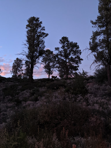
I live nearby here; mostly locals to Payson know about it. I have met a few valley folks that know this is the nearest Pines to Mesa; some take MTBikes back here too; keep your eyes open!

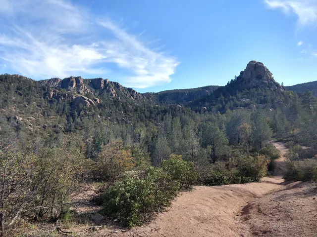
This is near town, but it's wilderness for miles, into Hells Kitchen area eventually, as rough as rough gets; I was out there on my bike today, and saw 2 baby deer, but virtually no water; mostly water is in the spring after snow melts. Come prepped with water; a good hat, sunblock. I have gotten in trouble back here, where I had to call my elder mother to come pick us up at Granite Dells; too tired to walk home in the heat. (Cell service works for me, if I'm up high enough.)

Go early in the day in Summer; it's shaded in parts, but the sun slows one down; on my way out, I saw people literally laying down on dirt, in the shade, just to rest near the trail. If you take a bike, too many hikers on weekends; plan on weekdays only.

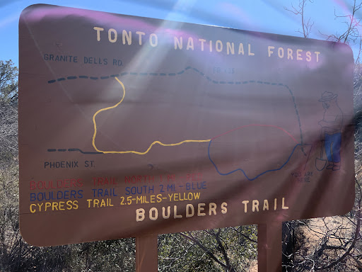
When you first arrive, go past the stupid gate, and sign that sez camera, 100-200 feet, and you will see a giant wash. There is a National forest sign there; you now are at the N. end of Boulder Loop. CROSS the wash directly West to the trail as it follows the wash west; and go south, and west, to start the S. end of Boulder Loop. The trail follows the washes, as trails will do; you are going West. Ignore the ranch and signs to the East; it's grandfathered land, surrounded by National Forest lands, from 150 years ago..

Eventually the trails are marked; look for 4 ft tall steel pillars with arrows on them. If you lose the trail, keep walking West, look for the markers; WELL MARKED but you have to be looking for them long after you start walking, and cross the giant washes.

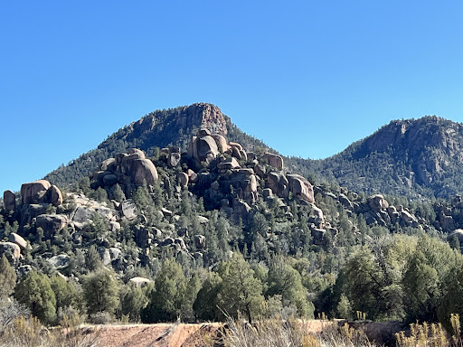
Trail Entrance is marked, trail starts are NOT MARKED well - wash only goes 2 different ways; N. West, and S. West; so follow the wash either way for the trail you want. Trails are mostly to the side of the wash, and cross it often back and forth, constantly. May be easier to start on Cypress Trail, but no parking on Granite Dells, where you can pick up Cypress Trail. When you get to Cypress Trail; it is marked well also; comes out at Phoenix St., and even further to the north, at Granite Dells, near the country club...

   Read more
avatar
5.0
5y

LOVED this hike! It was smooth walking the majority of the time with short steps over a beautiful creek. Driving there, We followed google maps to this trailhead. About 2 miles before arriving to the road, it turns to dirt. My Civic did just fine, just took it slow. We drove until a brown gate blocked the road, parked on the side of the road, and walked past the gate to the trail head.

We took one half of the loop (south trail) out, hit cypress trail, hiked the 2.5 miles till it ended, then turned back. Coming back, there’s a sign showing where the north / south boulder trail splits. We took the north route back.

Basic math shows that is 8 miles, but our step counter showed much less.

There were lots of dogs on the trail and The trail was really beautiful. Tons of good mountain views mixed with shaded creek walking. Make sure to listen for water falls in the distance so you can walk off trail to see them, that was our...

   Read more
Page 1 of 7
Previous
Next

Posts

Scott VleeschouwerScott Vleeschouwer
LOVED this hike! It was smooth walking the majority of the time with short steps over a beautiful creek. Driving there, We followed google maps to this trailhead. About 2 miles before arriving to the road, it turns to dirt. My Civic did just fine, just took it slow. We drove until a brown gate blocked the road, parked on the side of the road, and walked past the gate to the trail head. We took one half of the loop (south trail) out, hit cypress trail, hiked the 2.5 miles till it ended, then turned back. Coming back, there’s a sign showing where the north / south boulder trail splits. We took the north route back. Basic math shows that is 8 miles, but our step counter showed much less. There were lots of dogs on the trail and The trail was really beautiful. Tons of good mountain views mixed with shaded creek walking. Make sure to listen for water falls in the distance so you can walk off trail to see them, that was our favorite part.
NATURE OF ALL THINGSNATURE OF ALL THINGS
The boulder loop trailhead is a wonderful trail to do when it not to hot outside. Maybe you can try it when there some snow but probably be to cold and to icy in winter. It is also a great place to take pictures if that's some you like to do. It is also a great place to just go to get away from City Life and be in nature and still be close to civilization. So definitely would recommend this trail head to anybody who enjoys nature and taking pictures and exercising.
siccen ssiccen s
We went in February when the gate to the main trailhead was closed. There is enough room for a few cars to park in front of the main trailhead gate however. No one was there but us. Beautiful scenery. We saw fresh Black bear poop and decided to turn around early into the hike. I didn't have my fire arm on me and I didn't want to risk running into a Black bear. It's a nice little dirt road that takes you to the trailheadoff the main highway. About 3 miles.
See more posts
See more posts
hotel
Find your stay

Pet-friendly Hotels in Star Valley

Find a cozy hotel nearby and make it a full experience.

LOVED this hike! It was smooth walking the majority of the time with short steps over a beautiful creek. Driving there, We followed google maps to this trailhead. About 2 miles before arriving to the road, it turns to dirt. My Civic did just fine, just took it slow. We drove until a brown gate blocked the road, parked on the side of the road, and walked past the gate to the trail head. We took one half of the loop (south trail) out, hit cypress trail, hiked the 2.5 miles till it ended, then turned back. Coming back, there’s a sign showing where the north / south boulder trail splits. We took the north route back. Basic math shows that is 8 miles, but our step counter showed much less. There were lots of dogs on the trail and The trail was really beautiful. Tons of good mountain views mixed with shaded creek walking. Make sure to listen for water falls in the distance so you can walk off trail to see them, that was our favorite part.
Scott Vleeschouwer

Scott Vleeschouwer

hotel
Find your stay

Affordable Hotels in Star Valley

Find a cozy hotel nearby and make it a full experience.

Get the Appoverlay
Get the AppOne tap to find yournext favorite spots!
The boulder loop trailhead is a wonderful trail to do when it not to hot outside. Maybe you can try it when there some snow but probably be to cold and to icy in winter. It is also a great place to take pictures if that's some you like to do. It is also a great place to just go to get away from City Life and be in nature and still be close to civilization. So definitely would recommend this trail head to anybody who enjoys nature and taking pictures and exercising.
NATURE OF ALL THINGS

NATURE OF ALL THINGS

hotel
Find your stay

The Coolest Hotels You Haven't Heard Of (Yet)

Find a cozy hotel nearby and make it a full experience.

hotel
Find your stay

Trending Stays Worth the Hype in Star Valley

Find a cozy hotel nearby and make it a full experience.

We went in February when the gate to the main trailhead was closed. There is enough room for a few cars to park in front of the main trailhead gate however. No one was there but us. Beautiful scenery. We saw fresh Black bear poop and decided to turn around early into the hike. I didn't have my fire arm on me and I didn't want to risk running into a Black bear. It's a nice little dirt road that takes you to the trailheadoff the main highway. About 3 miles.
siccen s

siccen s

See more posts
See more posts