HTML SitemapExplore

Dajti — Local services in Tirana Municipality

Name
Dajti
Description
Dajti is a mountain located in central Albania, just east of the capital, Tirana. Part of the Skanderbeg Mountains range, it stretches from Shkalla e Tujanit in the northwest to Qafa e Priskës in the southeast, at a length of 8 km and a width of 5 km. Its highest peak, Maja e Dajtit, reaches a height of 1,613 m.
Nearby attractions
Nearby restaurants
Nearby local services
Nearby hotels
Related posts
Keywords
Dajti tourism.Dajti hotels.Dajti bed and breakfast. flights to Dajti.Dajti attractions.Dajti restaurants.Dajti local services.Dajti travel.Dajti travel guide.Dajti travel blog.Dajti pictures.Dajti photos.Dajti travel tips.Dajti maps.Dajti things to do.
Dajti things to do, attractions, restaurants, events info and trip planning
Dajti
AlbaniaCentral AlbaniaTirana MunicipalityDajti

Basic Info

Dajti

Albania
4.6(310)
Save
spot

Ratings & Description

Info

Dajti is a mountain located in central Albania, just east of the capital, Tirana. Part of the Skanderbeg Mountains range, it stretches from Shkalla e Tujanit in the northwest to Qafa e Priskës in the southeast, at a length of 8 km and a width of 5 km. Its highest peak, Maja e Dajtit, reaches a height of 1,613 m.

Outdoor
Adventure
Scenic
attractions: , restaurants: , local businesses:
logoLearn more insights from Wanderboat AI.

Plan your stay

hotel
Pet-friendly Hotels in Tirana Municipality
Find a cozy hotel nearby and make it a full experience.
hotel
Affordable Hotels in Tirana Municipality
Find a cozy hotel nearby and make it a full experience.
hotel
The Coolest Hotels You Haven't Heard Of (Yet)
Find a cozy hotel nearby and make it a full experience.
hotel
Trending Stays Worth the Hype in Tirana Municipality
Find a cozy hotel nearby and make it a full experience.

Reviews

Get the Appoverlay
Get the AppOne tap to find yournext favorite spots!
Wanderboat LogoWanderboat

Your everyday Al companion for getaway ideas

CompanyAbout Us
InformationAI Trip PlannerSitemap
SocialXInstagramTiktokLinkedin
LegalTerms of ServicePrivacy Policy

Get the app

© 2025 Wanderboat. All rights reserved.

Reviews of Dajti

4.6
(310)
avatar
5.0
2y

Definitely a highlight of a visit to Tirana, worth the 1400 ALL return ticket for the cable car.

GETTING THERE: The cable car station can be reached by the L11 bus (Porcelan); a single ticket is just 40 ALL (simply board the bus, a ticket seller will come to you). This bus seems to leave every 10 minutes or so, but I recommend using an app such as Moovit to see all the stops as it's hard to find this info online. Bus stops aren't announced or marked, so ask the driver where to get off or track your ride and get off at the first stop after the Bunkart museum. From there, it's a 5min walk uphill to the cable car. The return bus leaves from the same station. Also easily walkable from the center in about 1h.

HIKING: From the upper station, you can easily reach two Dajti peaks, Maja e Dajtit (the higest peak, 1613m) and Maja e Tujanit (1524m). The trails are marked, starting from the abandoned hotel. These are easy hikes; however, the initial section through the forest can be muddy and slippery if it's been raining. The ascent to Maja e Tujanit is short and somewhat steeper and the peak offers a great view of the Bovilla Lake. The ascent to the Dajti peak is longer but very gradual. You can't actually climb the peak as it's in the military zone and the trail only takes you to an ugly antenae below the peak, with no views. As an alternative, follow the road to the Dajti peak, but instead of taking the last right turn below the peak, just keep following the road (unmarked from this point). Right after the turn, you'll see a gate that marks the beginning of the military zone. Don't go up to the gate; keep your eyes on the thicket to the right. There's a narrow but obvious path there that leads to a ruin of a house. Enjoy the view! The recommended time for this trail (from an on-site board in Albanian) is 2.5h, one way. The whole trail from the upper station and back took me just under 3h, partly in the fog (an amazing experience), 8km total. You can also keep following the same (marked) trail past the Dajti peak and along the ridge of...

   Read more
avatar
5.0
5y

Dajti National Park was declared a national park in 1966, and has an expanded area of about 29,384 hectares since 2006. The area is under shared jurisdiction between Albanian Agency of Protected Areas (AKZM) and Tirana Municipality Parks and Recreation Agency (APR). In 2017, the new Dajti Mt National Park tourist information center was opened located near the TV and Radio towers along SH47 road in Fushe Dajt. The mountain can be reached through a narrow asphalted mountain road onto an area known as Fusha e Dajtit. This was the location of a summer camp but now is the site of many restaurants and radio and TV transmitters. From this small area there is an excellent view of Tirana and its plain. This is the reason this place has been named as the Balcony of Tirana. From June 2005, hikers and visitors of the mountain can use an Austrian built gondola lift from the eastern outskirts of Tirana to Fusha e Dajtit (Plain of Dajti) at 1050 meters altitude. On the summit of Mount Dajti there exist several radio and TV transmitters. Lately, traces of prehistoric settlements and fortifications from later periods have been discovered in the area.

Content is available...

   Read more
avatar
5.0
3y

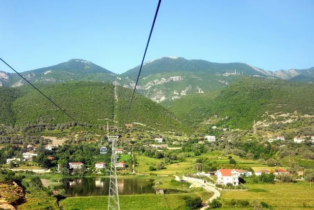
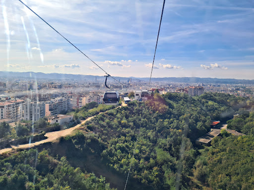
Parku Kombëtar i Dajtit është mali më i afërt me qytetin, vetëm 25 km në lindje të Tiranës (1611 metra i lartë). Një udhëtim atje, është një ndër aktivitetet më të preferuara turistike në  Tiranë. Duhen 20 minuta me makinë ose autobus nga qendra e Tiranës deri te stacioni i Teleferikut. Më pas ju merrni Teleferikun për të përjetuar një aventure të mrekullueshme.  Një udhëtim mbresëlënës dhe i këndshëm që ia vlen për pamjen që të ofron. Për 13 minutash udhëtim ju mund të ngjiteni në majën e malit nga ku do të shihni një pamje panoramike të qytetit, fshatra, pyje, bunkerë, shtëpi dhe  gjithë rrethinat. Është një vend perfekt për t’u relaksuar dhe për të thithur ajër të pastër dhe larg zhurmave të Tiranës. Ju mund të shkoni në restorante, të shijoni ushqimin e shijshëm, ose të qëndroni në park të bëni një piknik me miqtë apo familjarët. Ky park është atraktiv gjatë gjithë stinëve, por kryesisht në verë, për freskine qe ofron dhe në dimër kur Mali mbulohet nga bora. Përfundimisht Mali i Dajtit është një nga destinacionet më të mira për të vizituar ndërsa jeni në Tiranë. Parku Kombëtar i Dajtit është vendosur  26 km në lindje të Tiranës. Ai zë një sipërfaqe prej 3,300 ha të rrafshnaltës së Dajtit. Ky park tërheq shumë vizitorë dhe është një vend i përshtatshëm  për piknik familjar, sporte, lojëra si dhe aktivitete të tjera interesante. Parku i Dajtit ka një florë dhe faunë mjaft të pasur. Bimësia e dendur e bën atë një nga zonat më të gjelbëruara në vend. Parku është i njohur për pyjet e tij ku gjenden tre kate bimore: shkurret mesdhetare me dy nën katet: makjen (bimët gjithnjë të gjelbra si shqopa, mareja, etj) dhe shkozën, dushqet si dhe kati i ahut. Pylli i Dajtit  konsiderohet i paprekur nga njeriu dhe si i tillë ka vlera të mëdha shkencore dhe ekologjike.

Mjaft e pasur është edhe fauna e Parkut të Dajtit, që përbëhet nga tetë lloje gjitarësh: ariu, ujku, lepuri, iriqi, lundërza, disa lloj lakuriqësh nate, ketri, etj, nga 11 lloje shpendësh: 3 lloje shqiponjash, petriti, huta, katër lloje qukapikësh, thëllëza e maleve, nga shtatë lloje zvarranikësh, katër lloje amfibësh, etj.

Kjo zonë e mbrojtur është dhe një nga parqet kombëtare më të populluar  në Shqipëri. Parku ka vlera të mëdha sportive me mundësitë për ushtrimin e alpinizmit në thepisjet e mëdha shkëmbore, për marshuta në park, për ushtrimin e sportit të rrëshqitjes me ski në lartësinë e qafës së Qershisë, etj. Vlerat e veçanta turistike të tij lidhen me klimën e shëndetshme, ajrin e pastër, pyllin e dendur, format e relievit, peizazhet e mrekullueshme që shpalosen nga lartësitë e tij si Tirana, fusha e Erzenit të Poshtëm, Durrësi dhe deti Adriatik. Adresa: 13 minuta nga Qendra e Tiranes tek Stacioni i Teleferikut. Me makine private Distanca: 40...

   Read more
Page 1 of 7
Previous
Next

Posts

Antonija MagašAntonija Magaš
Definitely a highlight of a visit to Tirana, worth the 1400 ALL return ticket for the cable car. GETTING THERE: The cable car station can be reached by the L11 bus (Porcelan); a single ticket is just 40 ALL (simply board the bus, a ticket seller will come to you). This bus seems to leave every 10 minutes or so, but I recommend using an app such as Moovit to see all the stops as it's hard to find this info online. Bus stops aren't announced or marked, so ask the driver where to get off or track your ride and get off at the first stop after the Bunkart museum. From there, it's a 5min walk uphill to the cable car. The return bus leaves from the same station. Also easily walkable from the center in about 1h. HIKING: From the upper station, you can easily reach two Dajti peaks, Maja e Dajtit (the higest peak, 1613m) and Maja e Tujanit (1524m). The trails are marked, starting from the abandoned hotel. These are easy hikes; however, the initial section through the forest can be muddy and slippery if it's been raining. The ascent to Maja e Tujanit is short and somewhat steeper and the peak offers a great view of the Bovilla Lake. The ascent to the Dajti peak is longer but very gradual. You can't actually climb the peak as it's in the military zone and the trail only takes you to an ugly antenae below the peak, with no views. As an alternative, follow the road to the Dajti peak, but instead of taking the last right turn below the peak, just keep following the road (unmarked from this point). Right after the turn, you'll see a gate that marks the beginning of the military zone. Don't go up to the gate; keep your eyes on the thicket to the right. There's a narrow but obvious path there that leads to a ruin of a house. Enjoy the view! The recommended time for this trail (from an on-site board in Albanian) is 2.5h, one way. The whole trail from the upper station and back took me just under 3h, partly in the fog (an amazing experience), 8km total. You can also keep following the same (marked) trail past the Dajti peak and along the ridge of the mountain.
Your browser does not support the video tag.
Maarja SaatMaarja Saat
Amazing views. Definitely a must when in Albania. The ride on Dajti express was very smooth and offered great views along the way.
Stephanie van GinhovenStephanie van Ginhoven
We went up with the cable car (€14,- per adult, up and down) and had a nice lunch at the restaurant at the top. After that we went for a walk up the mountain, to be identified by markers with white/red/white stripes. The climb was nice and relatively doable (1,5-2 hours up/1 hour down) , but I would not advise this with (younger or inexperienced) kids. Don't expect paved paths. When you come at a bigger crossroads with the signs from the picture, go left (not right). Even though right is higher and is the actual mount Dajt, the view on the left (mount Tujanit) is way better! You can look all over Tirana and even further and if you walk just a little longer and get to the very top, you can look land inwards and it is a-ma-zing. Would recommend. Enjoy!
See more posts
See more posts
hotel
Find your stay

Pet-friendly Hotels in Tirana Municipality

Find a cozy hotel nearby and make it a full experience.

Definitely a highlight of a visit to Tirana, worth the 1400 ALL return ticket for the cable car. GETTING THERE: The cable car station can be reached by the L11 bus (Porcelan); a single ticket is just 40 ALL (simply board the bus, a ticket seller will come to you). This bus seems to leave every 10 minutes or so, but I recommend using an app such as Moovit to see all the stops as it's hard to find this info online. Bus stops aren't announced or marked, so ask the driver where to get off or track your ride and get off at the first stop after the Bunkart museum. From there, it's a 5min walk uphill to the cable car. The return bus leaves from the same station. Also easily walkable from the center in about 1h. HIKING: From the upper station, you can easily reach two Dajti peaks, Maja e Dajtit (the higest peak, 1613m) and Maja e Tujanit (1524m). The trails are marked, starting from the abandoned hotel. These are easy hikes; however, the initial section through the forest can be muddy and slippery if it's been raining. The ascent to Maja e Tujanit is short and somewhat steeper and the peak offers a great view of the Bovilla Lake. The ascent to the Dajti peak is longer but very gradual. You can't actually climb the peak as it's in the military zone and the trail only takes you to an ugly antenae below the peak, with no views. As an alternative, follow the road to the Dajti peak, but instead of taking the last right turn below the peak, just keep following the road (unmarked from this point). Right after the turn, you'll see a gate that marks the beginning of the military zone. Don't go up to the gate; keep your eyes on the thicket to the right. There's a narrow but obvious path there that leads to a ruin of a house. Enjoy the view! The recommended time for this trail (from an on-site board in Albanian) is 2.5h, one way. The whole trail from the upper station and back took me just under 3h, partly in the fog (an amazing experience), 8km total. You can also keep following the same (marked) trail past the Dajti peak and along the ridge of the mountain.
Antonija Magaš

Antonija Magaš

hotel
Find your stay

Affordable Hotels in Tirana Municipality

Find a cozy hotel nearby and make it a full experience.

Get the Appoverlay
Get the AppOne tap to find yournext favorite spots!
Amazing views. Definitely a must when in Albania. The ride on Dajti express was very smooth and offered great views along the way.
Maarja Saat

Maarja Saat

hotel
Find your stay

The Coolest Hotels You Haven't Heard Of (Yet)

Find a cozy hotel nearby and make it a full experience.

hotel
Find your stay

Trending Stays Worth the Hype in Tirana Municipality

Find a cozy hotel nearby and make it a full experience.

We went up with the cable car (€14,- per adult, up and down) and had a nice lunch at the restaurant at the top. After that we went for a walk up the mountain, to be identified by markers with white/red/white stripes. The climb was nice and relatively doable (1,5-2 hours up/1 hour down) , but I would not advise this with (younger or inexperienced) kids. Don't expect paved paths. When you come at a bigger crossroads with the signs from the picture, go left (not right). Even though right is higher and is the actual mount Dajt, the view on the left (mount Tujanit) is way better! You can look all over Tirana and even further and if you walk just a little longer and get to the very top, you can look land inwards and it is a-ma-zing. Would recommend. Enjoy!
Stephanie van Ginhoven

Stephanie van Ginhoven

See more posts
See more posts