Come organiz per percorrere la strada del Grossglockner
Si tratta di una strada alpina privata a pedaggio ottimamente manutenuta (direi invidiabilmente gestita! ), aperta da maggio fino alla fine di novembre. Il costo per le auto é di 43 euro. I camper con portata inferiore ai 35 ql pagano come le auto. Camper con portata tra 35 ql e fino a 75 ql pagano 52,50 euro. La tariffa per i Camper giganti (sopra le 7,5 tonnellate) è di 135 euro. Tariffe estate 2024. Ma restiamo con i piedi per terra :-). La tariffa potrebbe sembrare esosa, ma il paesaggio merita davvero e credo sia in parte giustificato. Va detto anche che le strutture presenti e la condizione generale dell'intero percorso giustifiano gli enormi costi di gestione (si legga oltre). Tra l'altro i parcheggi (molti con addetti che sorvegliano e gestiscono il flusso) sono gratuiti. Sono presenti moltissimi spazi per soste brevi (per la classica foto) o soste prolungate, come ad esempio escursioni, salite ai rifugi, visite delle strutture, ristoranti, bar, negozi di souvenir, etc. Attenzione, non é permesso dormire né campeggiare sull' intera area compresa tra i caselli. Quindi no tende, no roulotte, no camper. In Austria non si scherza con i divieti. Sono capaci di far esplodere la terza guerra mondiale se vi beccano. In alcuni punti la carreggiata a due corsie, diventa a tre corsie, per agevolare i sorpassi dei veicoli più lenti (in Austria è frequente il "raddoppio" di corsia nelle strade di montagna). È davvero una bella trovata, anche per i motociclisti che non azzarda o imprudente sorpassi. Oltre alle numerose moto, troverete anche molti ciclisti. É frequente incontrare anche i veri ciclisti, quelli che confidano solo sui loro muscoletti ovvero senza e-bike, ai quali va tutta la mia ammirazione. La strada si può percorrere nei due sensi ovvero da Heiligenblut (via più breve per noi italiani o per chi proviene da Villach o da Lienz). L'altra via di accesso è da nord, precisamente da Fusch. Il lavoro per lo sgombero della neve é disumano...ogni anno in aprile,15 uomini con 4 frese, per tre settimane in media, asportano qualcosa come 600.000 metri cubi di neve dalle strade e dai parcheggi che ospiteranno circa 4.000 auto. Per dare l'idea corrisponde ad un treno lungo 180 km. Il record nel 1975 è stato di 800.000 mc con cumuli di neve alti anche 21 metri! Non oso immaginare le imprecazioni se, a lavoro ultimato, avesse ripreso a nevicare! Forse per questo ci sono tanti crocifissi in giro. Comunque gli addetti di oggi non si devono lamentare perché nel 1935 ben 350 persone dovevano lavorare per 70 giorni con pale e senza le frese (che tra l'altro vedrete parcheggiate in punti strategici)
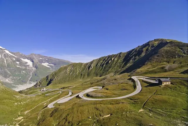
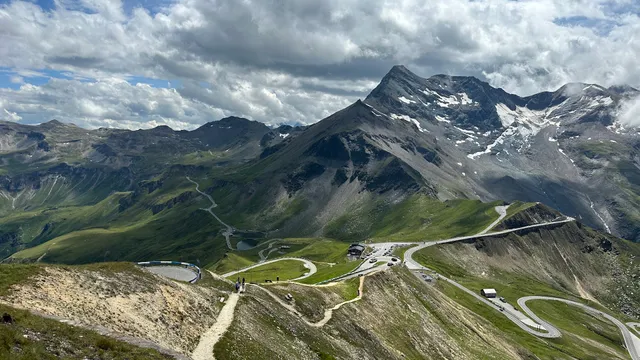
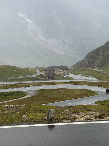
L'intero percorso è di 48 km con 36 tornanti e vi porterà a quota 2571 m (cima Stella Alpina - Edelweiss Spitze). Ufficialmente la strada del Grossglockner termina alla Kaiser Franz Josefs Höhe a quota 2369 metri. In quest'ultimo punto si arriva anche con il bus da Heiligenblut ed è presente un parcheggio a tre piani. Il Fraz Josef é una tra le tappe d'obbligo in quanto si trova di fronte al ghiacciaio Pasterze (il più lungo delle Alpi Orientali) e qui si capisce l'immensità. Sono presenti moltissime tabelle tematiche nelle quali spesso viene evidenziato quanto il ghiacciaio si sia ridotto in poco più di un secolo. La parte inferiore del ghiacciaio é grigio scuro (sembra più roccia che non ghiaccio). Per chi sale da Heiligenblut, dopo circa 6, 7 km si troverà ad un bivio. È opportuno girare a sinistra in direzione Schöneck e Kaiser Franz Josefs Höhe. Questo tratto dovrà essere percorso nuovamente a ritroso per poi completare il percorso e dirigersi verso Hochtor-Fuscher Lake-Fuscher Törl e scendere dall'altra parte della montagna che conduce a Fuschertal. Nell'intero percorso non ho visto distributori. In discesa, marcia bassa e usare i freni con moderazione, alcuni tratti sono piuttosto pendenti. Molti cartelli richiamano l'attenzione sui freni!
Per maggiori info leggete la mia recensione su TripAdvisor....
Read more