In the southern and central parts of the Kalahari Desert, surface water is found only in small, widely scattered waterholes, and surface drainage is nonexistent. Nearly all of the rain that falls disappears immediately into the deep sand. Some is absorbed by the underlying rock strata; some is drawn to the surface by capillary action and evaporated into the air; and some, lifted from the depths by tree roots, is transpired from leaf surfaces. A small amount, landing on nonsandy surfaces, may flow short distances into pans, but this occurs only immediately after the infrequent rains. In some parts of the central and southern Kalahari, extensive ancient drainage systems have been detected—some on the ground and others by way of aerial photographs. None of these operate today, even in the wettest of years.
In the northern Kalahari an extraordinary drainage system prevails. During the summer heavy rains fall on the uplands of central Angola, far to the northwest of the Kalahari. Large amounts of runoff water feed a number of south-flowing streams, which merge to form the Okavango and Cuando (Kwando) rivers. The Okavango flows to the southeast and into the northernmost portion of the Kalahari, eventually breaking up into a number of distributary channels and feeding the vast area of swamps in northern Botswana. After an abnormally wet rainy season in Angola, excess water fills the swamps and overflows, filling Lake Ngamifarther to the south, and flows eastward through the Boteti River into Lake Xau and the Makgadikgadi Pans. Similarly, the Cuando River flows south from Angola and partly into a northeastern extension of the same swamps. Thus is created the paradoxical situation of an area with an extensive excess of water in a region chronically short of...
Read more
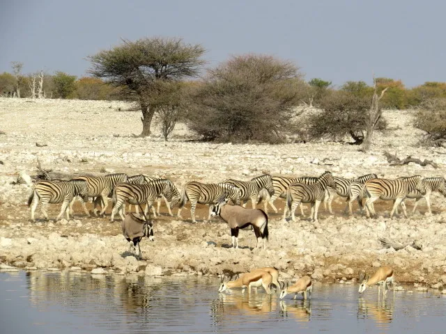
Kalahari Desert, large basinlike plain of the interior plateau of Southern Africa. It occupies almost all ofBotswana, the eastern third ofNamibia, and the northernmost part of Northern Cape province in South Africa. In the southwest it merges with the Namib, the coastal desert of Namibia. The Kalahari’s longest north–south extent is roughly 1,000 miles (1,600 kilometres), and its greatest east–west distance is about 600 miles; its area has been estimated at some 360,000 square miles (930,000 square kilometres).
Physiography and geology
The Kalahari Desert is a featureless, gently undulating, sand-covered plain, which everywhere is 3,000 feet (900 metres) or more above sea level. Bedrock is exposed only in the low but vertical-walled hills, called kopjes, that rarely but conspicuously rise above the general surface. Aside from the kopjes, three surfaces characterize virtually all of the Kalahari: sand sheets, longitudinal dunes, and vleis (pans).
The sand sheets appear to have been formed during the Pleistocene Epoch (about 2,588,000 to 11,700 years ago), and they have been fixed in place since then. In some areas they appear to have been of fluvial origin, the result of sheet flooding in times of much greater precipitation, but by far the greater part of them were wind-formed. The sheets occupy the eastern part of the Kalahari. Their surface elevation varies only slightly, with relief measured in tens of feet per mile. The depth of the sand there generally exceeds 200 feet. In many areas the sand is red, the result of a thin...
Read moreKalahari Çölü, Afrika'nın Güneyinde, 22° ile 28° Güney enlemleri, 19° ile 24° Doğu boylamları arasında yer alan yarı çöl plato alanı. Bölgenin yüzölçümü 900.000 km²'ye kadar varır (→ en:Kalahari Desert). Kalahari ismi genelde Botsvana'nın batı kısmına denilmekte olup çöl Botsvana'nın büyük bir kısmı ile Namibya ve Güney Afrika'nın bazı kesimlerini kaplar. Bölge geniş otlaklıklar, çalı ve ağaçlıklar ihtiva etmesine rağmen, yağış az olduğundan dolayı çöl denilmiştir. Bölgenin çok az bir kısmı bütün mevsimlerde çöl özelliği gösterir. Yıllık yağışlar kuzeydoğuda 600 mm'den Güneybatıda 130 mm'ye kadar değişiklik gösterir. Çok az yağış almasının sebebi, doğu doğrultusunda uzanan dağ sıralarının Hint Okyanusundan esen nemli rüzgarların etkisini azaltmasıdır. Bu dağların ortalama yüksekliği 900 ila 1200 m arasında değişir. Vadilerde antilop sürüsü, fil dahil birçok tropik bölge hayvanı bulunur ve serbestçe dolaşırlar. Toprak genelde kızıl renkli yumuşak kumlu olup, eski nehirlerin getirdiği alüvyonlar bulunur. Bu alüvyonlar sıcakta sertleşerek yağan yağmurlardan göletler meydana getirirler. Sebzeler yağış durumuna göre yüksek ormanlardan alçak bölgelere doğru değişir. Çok miktarda sebze yetiştiği gibi, bunlardan kavun, karpuz ve patates bol miktarda ekilir. Bölgede bulunan otlaklardaki otların çok olması, bunların çok iyi bir hayvan yemi olmasını sağlamaktadır. Bölgenin kıyılarına Bantu kabileleri yerleşmiş olmasına rağmen, buranın asıl sakinleri çölde yarı göçebe olarak yaşayan Boşimanlar (Buşmanlar) denilen, 2000 civarındaki sarı derili ormancılardır. Avcılık ve inşaatçılık gibi mesleklerle geçinirler. Bölgenin güneybatısı Kalahari Gemsboh Millî Parkı olup, 20.720 km² yer kaplamaktadır. Bu bölgedeki millî parkta nesli tükenmekte olan hayvanların bakımı ve korunması ülke tarafından kurulmuş olan millî park görevlileri tarafından sağlanmaktadır. ** The Kalahari Desert is a semi-desert plateau area located in the South of Africa between latitudes 22 ° and 28 ° South and longitude 19 ° and 24 ° East. The area of the region reaches up to 900,000 km² (→ most: Kalahari Desert). The name Kalahari is often referred to as the western part of Botswana, and the desert covers most of Botswana and parts of Namibia and South Africa. Although the region includes large grasslands, bushes and woodlands, it is called a desert because of the low rainfall. A very small part of the region shows desert characteristics in all seasons. Annual precipitation ranges from 600 mm in the northeast to 130 mm in the Southwest. The reason why it receives very little rainfall is that the mountain ranges in the east direction reduce the effect of the moist winds blowing from the Indian Ocean. The average altitude of these mountains ranges from 900 to 1200 m. There are antelope herds and many tropical animals, including elephants, in the valleys and they roam freely. The soil is generally red-colored, soft sandy, and there are alluviums brought by the old rivers. These alluviums harden in the heat and form ponds from the rains. Vegetables vary from high forests to low regions according to rainfall. As many vegetables are grown, melons, watermelons and potatoes are grown in large quantities. The abundance of grasses in the pastures in the region makes them a very good animal feed. Although Bantu tribes have settled on the coasts of the region, the main inhabitants of this area are around 2000 yellow-skinned foresters called Bosimans (Bushmen) who live in the desert as semi-nomads. They live in professions such as hunting and construction. The southwest of the region is the Kalahari Gemsboh National Park and covers an area of 20,720 square kilometers. The care and protection of endangered animals in the national park in this region is provided by the national park officials established by...
Read more