Section 4 Ma on shan is the best as there is a unique ridge. I reviewed each section separately in google maps.
I did Sec 1 and 2 combined in just over 6 hrs with lots of photo taking but jogged downhills or on boring flat parts. Bring less than 2 litres of water only as there are at least 2 shops to refill supplies. Don't eat at first one u see. I ate at Hing kee which sells gatorade and beer.
Section 1 - 299x bus from shatin Central terminus to last stop Sai Kung terminus. Walk next door to 94 bus line, usually 94 bus tonnes of ppl so fat chance getting on should u try to be smart and get off 299x earlier than last stop. There is 7 eleven for bottled water and snacks and public toilets.
Get off pak tam chung. I chose to walk across the road right past bus stop and store and do the Sheung yiu trail past museum as it is great warm up if u trail run and going straight to reservoir via road super boring as u will emerge back to that reservoir road with several km of it. If u can run, i suggest u do so u have enough daylight to do side trails. Ps learn how to run down steep hills and stairs fast, sort of like 45 degrees grapevine, u will save hours off the recommended times as i did and I'm over 95kg. The alternative for lazy ppl is to taxi it to east dam. There were tonnes of green taxis going past me.
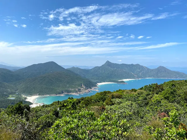
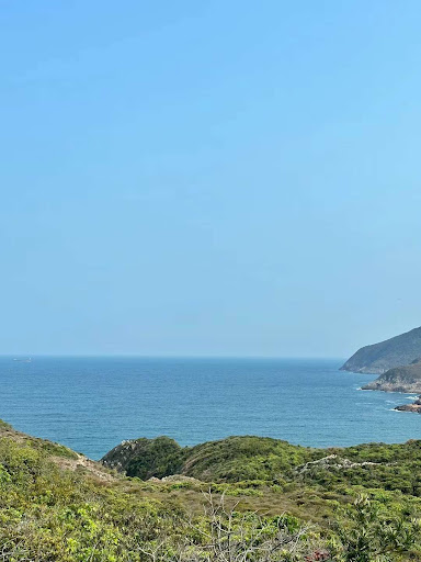
Section 2- long Ke Beach is the first beach u will encounter. There are a few more beaches after it in s2. Make sure you bring what u need eg towels if u go swimming. Lots of campers in tents everywhere. At the end of one of the beaches u need google maps or u might inadvertently deviate from the trail. At another there is a steep climb ahead so don't eat too much or u will be gasping for air. Ps I didn't eat lunch and just bought iceblocks, coke zero etc at the shops so I can keep going as I didnt want to re warmup
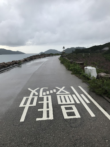
See if u can spot the mislabelled distance marker which says sec 1 instead of sec 2!!!!
U emerge from section 2 on road and left is bus stop to Sai Kung and across road from bus stop is section 3 start. If I were u I would not do section 3 right after s1 n 2 as it takes hours to get back to civilisation and queues super lo g late afternoon. Imo better to come back another day to do s3 4 together on separate day so u don't have to carry extra weight from tents etc.
Section 4- 5 - Gilwell campsite is in the middle of nowhere, no transport, so make sure you don't end up there as your end point cos it will take hours to get out of there. Google exit points such as City One mtr and plan ahead.
For Sec 5, I would recommend that you substitute either Suicide cliff (google this, start from the left side road near persons home, bottom of fei ngo shan road and start from the side road instead of taking the car road up) to lion rock and continue to end section 5,as a day trip and exit .
2nd Alternative, take stairs on right of fat jong temple (not car road) up lions Rock butt. It is more rewarding than just following section 5 and views much better. After lion rock it is easy hike.
Sec 6 is relatively easy compared to to 3rd sections and to be honest you want to spend lots of time exploring the wartime tunnels (research it first) with a torch in shing mun redoubt. Get a cheap headlamp. (Apart from these tunnels, u can use it when exploring Japanese war time tunnels under jardines lookout hike)
Detour----Shing mun reservoir actually has some hidden gems which can be found if u zoom in in google maps and look at the two photo locations up from the toilet near Wilson trail (dragon Valley), start from bottom ie west and east , jump onto huge rocks and follow the stream rocks up. TrulyI only got my feet wet once throughout the rock hopping. At Dragon Valley, follow the trail path back.
So instead of heading south, u can head north from pineapple dam and even rejoin mac Sec 7 by taking wilson trail sec 7. steep concrete up, but u bypass needle Hill
Sec 7, easy hiking lead mine pass via needle Hill.
Sec 8 Tai mo shan, the concrete path before top kills calves!
Sec 9-10, super boring on...
Read more