With its monumental canyon this is one of the most beautiful rivers in this part of Europe. Also it is one of the cleanest rivers in Croatia, and also in Europe. River finds its way to Adriatic sea in city of Omis. Cetina River is the biggest middle Dalmatian river. With its magnificent canyon is definitely one of the most beautiful place in Croatia. In the last 20 years it has become one of the centers for rafting and kayaking on the wild and calm waters. River is the lifeblood of central Dalmatia, surrounded by a small, peaceful villages, and it is extremely important for geological and archaeological research.Cetina springs at an altitude of 385 meters, on the northwestern slopes of mountain Dinara, near the village of Cetina, 7 km north of Vrlika. There are eight springs of the river, and the largest source of river is Glavas lake, deep more than 130 meters. Above the river source, only a few hundred meters away, there is a prehistoric cave called Gospodska pecina (Gentlemans Cave). It served as a habitat for people in different epochs. Both banks of the river and the surrounding slopes of mountains that surround it, are very rich archaeological sites. Archaeologists in the nearby karst areas and in the mud have find many valuable findings that are a living witnesses of their time, now exhibited at the Museum of Cetina in Sinj. River is long more than 100 km. It was tamed by building the Peruča lakes artificially created 25 kilometers downstream from the source. After Peruča lake the river passes karst areas and Sinj fields and flows towards the town of Sinj. It continues to flow to Gardun near Trilj, and enters the canyon and flows to the south. Over the canyon is fortress Nutjak. Fortress once served as a protection against the Turks over the west of the canyon. The coasts in a canyon are nearer and longer, and the river is deeper and slower. Cetina in Bisko turns to the southeast, near Sestanovac it turns towards left to the south, and near Zadvarje hugs Mosor while still flowing to the west. In Omis, it finally enters into the Adriatic Sea. From its mouth, Cetina is navigable to the resort Radman's Mills (Radmanove Mlinice), which is 6 km far from the mouth. There you can enjoy in the beautiful nature, and in a excellent restaurant. Be sure to find couple of beaches on the river banks, and refresh yourself in the clean river. Since Radman's Mills are only open after 1st May (they are a favorite picnic spot for the celebration of the Labor Day), there is also an excellent restauran 2 km towards the river mouth which is called Kastel Slanica. It is an incredible pleasure to take a ride on the boat from the mouth to the Radman mills. Boats can be rented at the mouth of the river, and every day bigger boats are sailing to Radmans Mills, that can carry larger groups. And those who love the adrenaline fun, can go rafting or canoeing on the beautiful canyon. River enters the Adriatic Sea in the town of Omis and that is a fantastic setting for a town. Near town, only 20 km far, in city Zadvarje, is located an amazing waterfall called Gubavica. Waterfall is one of the biggest in Croatia and it is more than 50...
Read moreCetina je rijeka koja pripada Jadranskomslijevu, a nalazi se u Splitsko-dalmatinskoj županiji. Duga je 105 km i ulijeva se u Jadransko more kod Omiša. 
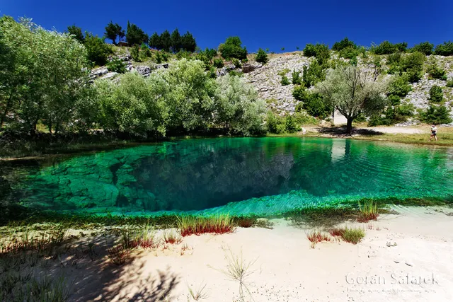
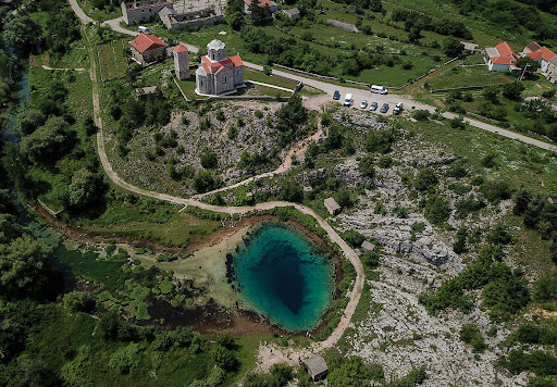
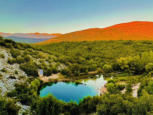
Cetina izvire na nadmorskoj visini od 385 m u sjeverozapadnim obroncima Dinare blizu sela Cetine, 7 km sjeverno od Vrlike. Ima više izvora, a glavni je izvor jezero duboko preko stotinu metara. [1] Iznad izvora rijeke Cetine, sjeverno od Vrlike, nalazi se Gospodska pećina, znamenita po naseljenosti u prapovijesnom dobu.[2]
Blizu Vrlike započinje Perućko jezero, umjetno stvoreno branom na Cetini 25 km nizvodno. Nakon jezera rijeka prolazi krškim područjem i Sinjskim poljem prema gradu Sinju. Cetina pod Gardunom, kod grada Trilja, napušta Sinjsko polje, ulazi u kanjon te teče prema jugu. Nad kanjonom je utvrda Nutjak. Obale su u kanjonu bliže i više, a rijeka duboka i spora. Nekad je voda brzo tekla i okretala brojne mlinove, ali su je brane usporile. Cetina kod Biskog skreće prema jugoistoku, a od tu je prati i autocesta A1. Cetina kod Šestanovcaskreće prema jugu, prolazi ispod A1, a uskoro zatim kod Zadvarja zaokreće oko Mosora i dalje plovi prema zapadu. U Omišu se ulijeva u Jadransko more. površina porječja 3700 km. Ušće cetine je Omiš . Gradovi cetine su : Sinj, Trilj i Omiš.
Tijekom ljetne turističke sezone, u donjem toku Cetine (od Slimena do Radmanovih mlinica kod Omiša), svakodnevno se, dva puta dnevno u trajanju od 3 do 4 sata odvija rafting.
PritociUredi
Lijevi su pritoci Cetine redom Rumin,Kosinac i Ruda. Dragović i Dabar također su lijevi pritoci, ali su potopljeni Perućkim jezerom. Glavni je desni pritok Vojskova (koja se u literaturi spominje i kao Vojskava). [3]. Neposredno prije utoka u Cetinu, u Vojskovu utječe Karakašica pa se ona u literaturi znade spominjati desnim pritokom Cetine (umjesto Vojskove).[1]. Sliv Cetine ima mnoštvo manjih rječica i izvora (Tako ti trista i šezdeset vrila šta se u Cetinu sliva [4]). Samo u širem području sela Hrvaca ima više od 50 izvora (koji...
Read moreThe Cetina river runs for about 65 miles before letting out into the Adriatic Sea. Its waters flow at the foot of the Dinara, the highest mountain massif in Croatia. It is known as the “eye of the earth” due to its strong resemblance to an eye with varied shades of blue and turquoise. Seen from above, it is undoubtedly one of the most particular and fascinating beauties of the region. This small body of water is formed by a hole that penetrates depths unknown of the Earth, explored by divers who made it to 115 meters. This natural karst splendor leaves all...
Read more