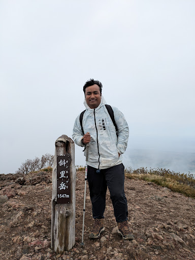
HTML SitemapExplore

Mount Shari — Local services in Kiyosato

Name
Mount Shari
Description
Mount Shari is a quaternary stratovolcano and one of Japan's 100 famous mountains. Its summit is 1,547 metres. The summit consists of Mount Shari, Southern Mount Shari and the western ridge.
Nearby attractions
Nearby restaurants
Nearby local services
Nearby hotels
Related posts
Keywords
Mount Shari tourism.Mount Shari hotels.Mount Shari bed and breakfast. flights to Mount Shari.Mount Shari attractions.Mount Shari restaurants.Mount Shari local services.Mount Shari travel.Mount Shari travel guide.Mount Shari travel blog.Mount Shari pictures.Mount Shari photos.Mount Shari travel tips.Mount Shari maps.Mount Shari things to do.
Mount Shari things to do, attractions, restaurants, events info and trip planning
Mount Shari
JapanHokkaido PrefectureKiyosatoMount Shari

Basic Info

Mount Shari

Konan, Kiyosato, Shari District, Hokkaido 099-4404, Japan
4.5(93)
Save
spot

Ratings & Description

Info

Mount Shari is a quaternary stratovolcano and one of Japan's 100 famous mountains. Its summit is 1,547 metres. The summit consists of Mount Shari, Southern Mount Shari and the western ridge.

Outdoor
Adventure
Scenic
Off the beaten path
attractions: , restaurants: , local businesses:
logoLearn more insights from Wanderboat AI.

Plan your stay

hotel
Pet-friendly Hotels in Kiyosato
Find a cozy hotel nearby and make it a full experience.
hotel
Affordable Hotels in Kiyosato
Find a cozy hotel nearby and make it a full experience.
hotel
The Coolest Hotels You Haven't Heard Of (Yet)
Find a cozy hotel nearby and make it a full experience.
hotel
Trending Stays Worth the Hype in Kiyosato
Find a cozy hotel nearby and make it a full experience.

Reviews

Get the Appoverlay
Get the AppOne tap to find yournext favorite spots!
Wanderboat LogoWanderboat

Your everyday Al companion for getaway ideas

CompanyAbout Us
InformationAI Trip PlannerSitemap
SocialXInstagramTiktokLinkedin
LegalTerms of ServicePrivacy Policy

Get the app

© 2025 Wanderboat. All rights reserved.

Posts

Md BadiruzzamanMd Badiruzzaman
In September, hiking Mount Shari is a stunning experience, especially when taking the waterfall route. The vibrant colors of the fall foliage create a striking contrast against the rugged terrain, making the ascent both visually rewarding and peaceful. The sound of cascading water accompanies you as you trek upward, adding a refreshing atmosphere to the challenging climb. The trail, while demanding, feels more serene with fewer crowds, allowing for quiet reflection and connection with nature. The crisp autumn air and scenic views from the summit make the effort completely worthwhile.
Your browser does not support the video tag.
JIM KJIM K
2024/8登頂。旧道は沢登りのような道になります。結構きつい斜面も有って腕力も要ります。沢は明るくて青空が広がり気持ちいい。帰りは新道で下りました
yui yamagishiyui yamagishi
北海道にある日本百名山 斜里岳(1547m)に登ってきました! 知床半島の付け根にあります⛰ オホーツク海側からは裾野が広く富士山型の独立峰に見えるため「オホーツク富士」や「斜里富士」という名も持ち合わせているようです💪✨ 登山時間はトータル6時間🥾 登りは渡渉のルートを探しながら沢に沿って登っていくというワイルドなコースを選択笑 今までに体験したことがない沢登りを2時間ほどこなしました🔥 下二股からはいくつもの滝が姿を現し、アスレチックな沢登りと相まって、楽しみながら高度を上げていくことができます! そして気づいたのですが、私沢登りが得意でスピードも速い笑笑 クノイチの如く🥷川を素早く渡り、石を得意げにジャンプしていました🤣 途中からスピードが上がって、両親を置いて行くほど(いつもは登りが遅くて置いていかれる方🤘) 途中、新道と頂上で道が分かれるのですが、私があまりにも早く登っていくもんだから道を間違えたのでは?と思ったらしく下山する人に聞いていたみたい🙏 下山の男性曰く「若い人は見なかったなー。若かったら忘れないですもん!」とジョークもあったとか😂 何はともあれ頂上前で合流したので一安心! こちら沢登り後に、岩手から来ていたおじちゃんと話が盛り上がり一緒に登山⛰なんと北海道4つ登山中らしい!!凄まじい体力🫣🔥 最後は家族で登頂完了❣️ 山頂からは羅臼岳や阿寒の山々、オホーツク海や国後島、遠くには大雪山も見渡せ、大パノラマの素晴らしい眺望を楽しめました✨ まさに最後まで飽きない!ワクワクを感じられる登山🥰 これだから登山は面白い。
See more posts
See more posts
hotel
Find your stay

Pet-friendly Hotels in Kiyosato

Find a cozy hotel nearby and make it a full experience.

In September, hiking Mount Shari is a stunning experience, especially when taking the waterfall route. The vibrant colors of the fall foliage create a striking contrast against the rugged terrain, making the ascent both visually rewarding and peaceful. The sound of cascading water accompanies you as you trek upward, adding a refreshing atmosphere to the challenging climb. The trail, while demanding, feels more serene with fewer crowds, allowing for quiet reflection and connection with nature. The crisp autumn air and scenic views from the summit make the effort completely worthwhile.
Md Badiruzzaman

Md Badiruzzaman

hotel
Find your stay

Affordable Hotels in Kiyosato

Find a cozy hotel nearby and make it a full experience.

Get the Appoverlay
Get the AppOne tap to find yournext favorite spots!
2024/8登頂。旧道は沢登りのような道になります。結構きつい斜面も有って腕力も要ります。沢は明るくて青空が広がり気持ちいい。帰りは新道で下りました
JIM K

JIM K

hotel
Find your stay

The Coolest Hotels You Haven't Heard Of (Yet)

Find a cozy hotel nearby and make it a full experience.

hotel
Find your stay

Trending Stays Worth the Hype in Kiyosato

Find a cozy hotel nearby and make it a full experience.

北海道にある日本百名山 斜里岳(1547m)に登ってきました! 知床半島の付け根にあります⛰ オホーツク海側からは裾野が広く富士山型の独立峰に見えるため「オホーツク富士」や「斜里富士」という名も持ち合わせているようです💪✨ 登山時間はトータル6時間🥾 登りは渡渉のルートを探しながら沢に沿って登っていくというワイルドなコースを選択笑 今までに体験したことがない沢登りを2時間ほどこなしました🔥 下二股からはいくつもの滝が姿を現し、アスレチックな沢登りと相まって、楽しみながら高度を上げていくことができます! そして気づいたのですが、私沢登りが得意でスピードも速い笑笑 クノイチの如く🥷川を素早く渡り、石を得意げにジャンプしていました🤣 途中からスピードが上がって、両親を置いて行くほど(いつもは登りが遅くて置いていかれる方🤘) 途中、新道と頂上で道が分かれるのですが、私があまりにも早く登っていくもんだから道を間違えたのでは?と思ったらしく下山する人に聞いていたみたい🙏 下山の男性曰く「若い人は見なかったなー。若かったら忘れないですもん!」とジョークもあったとか😂 何はともあれ頂上前で合流したので一安心! こちら沢登り後に、岩手から来ていたおじちゃんと話が盛り上がり一緒に登山⛰なんと北海道4つ登山中らしい!!凄まじい体力🫣🔥 最後は家族で登頂完了❣️ 山頂からは羅臼岳や阿寒の山々、オホーツク海や国後島、遠くには大雪山も見渡せ、大パノラマの素晴らしい眺望を楽しめました✨ まさに最後まで飽きない!ワクワクを感じられる登山🥰 これだから登山は面白い。
yui yamagishi

yui yamagishi

See more posts
See more posts

Reviews of Mount Shari

4.5
(93)
avatar
5.0
21w

August 26, 2025

what a hike. this is a doozy. this post will largely be for foreigners who may not be packing all the gear recommended or worn by avid japanese mountaineers and cant likely read the all japanese signs along the route:

Route: no doubt you should take the old waterfall route up and the new ridge route down

Gear: despite the many posts, regular workout gear will suffice. i had cottton shorts (got soaked, better would have been running shorts or some kind of river pant), running t-shirt and regular running shoes. was totally fine. brought my northface shell but only put it on briefly approaching summit as was chilled. you will be soaked from sweat, brushing foiliage and waterfall

Time: warden and consensus posts is 7.5-8 hrs round trip. 4 up and 3.5 down. i managed in 4.5hrs round trip but fell about 15 minutes short of summit itself. while i am capable of bursts of determination, i am a slightly overweight 58 yr old who stopped for a couple smoke breaks. was not best day as was socked in and the winds were so strong once crested the top ridge that almost knocked me over and visibility was non existent. i knew i was alone as a pair of hikers were far behind me and no way i was going further. its a trend i've noticed throughout hikes in japan, you can shave 30-40% off the recommended time without too much effort

Difficulty: its no joke. you will cross stream couple dozen times, you will be on all fours a lot, you will smash your head on overhead branches, you will be soaked and exhausted but it is stunning

Supplies: i had spare socks but couldnt be bothered as despite feet submerging at times, it wasnt really an impediment. good workout clothes and shoes will suffice but bring a shell for sure. i had 1 litre of water and bunch of snacks from 7-11 but only scarfed down the salmon jerky as didnt want to give the bears any false hope and most of my fluid was consumed 30 minutes from the end of the hike. granted it wasnt sunny so that may be a variable to consider

Path: its easy enough. follow the pink ribbons up the creek/waterfall. the old&new route diverge after first hr or so then reconvene about an hour below the summit, just above the waterfalls. those intersections are easy to figure out. however, once start descending on the new/ridge route, there will be 2 forks in path in no time. you DONT want to turn right/downhill but rather stay left (high). the forks are just a little detour for those that did the ridge up so they can drop down to see some falls. take a photo of the map at the wardens office. i chose left as recalled it was a ridge path and didnt want to drop downhill right away but 40 minutes along the ridge, i hadnt lost any elevation and was seriously questioning my decision. i was relieved when i did finally start to lose elevation.

Sign in: as always, you are expected to sign in at trailhead. i went inside to speak to most gracious man who runs the hut. he had spent time in Squamish for a period (just outside my hometown of vancouver) as most international mountaineers do and was full of great tips and encouragement that i should do the waterfall route. some posts made it sound quite intimidating without right gear but late august, the water levels werent so bad and running shoes were totally fine

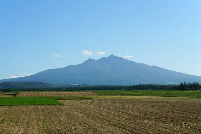
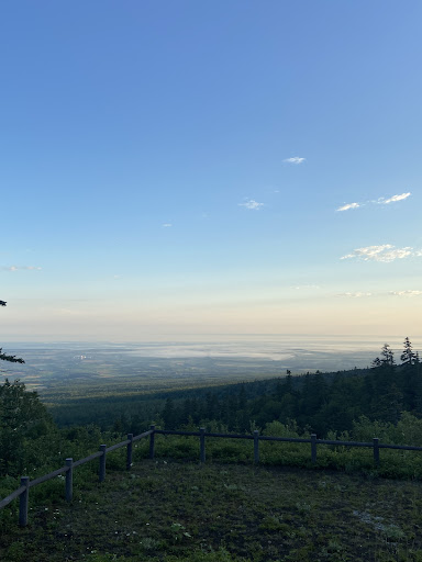
this will undoubtedly be one of the most memorable hikes you ever do and with any luck it will be a clear day but well...

   Read more
avatar
5.0
1y

斜里岳登山:北海道を代表する絶景と挑戦的なルート

斜里岳(しゃりだけ)は、北海道の知床半島の付け根に位置する標高1,547メートルの山で、日本百名山の一つです。山頂からはオホーツク海や知床連山を望むことができ、北海道らしい雄大な景色を楽しめます。登山ルートは変化に富み、沢登りや鎖場があるため、登山初心者にとってはややハードですが、経験者にとっては充実感のある山です。以下では、斜里岳登山の特徴やおすすめのルート、注意点について紹介します。

  1. 斜里岳の特徴と魅力 斜里岳は、独立峰としてそびえるため、山頂からの眺望が素晴らしい山です。登山道には滝や沢沿いの道があり、北海道ならではの自然を感じながら登山が楽しめます。また、山頂からは知床連山やオホーツク海、遠くは阿寒岳や雌阿寒岳などの絶景が広がり、晴れた日は特に壮大なパノラマビューを満喫できます。

沢登りと絶景: 登山道の途中には沢を登るルートがあり、水音を聞きながらの登山は、斜里岳ならではの楽しみです。 多彩な景観: 森林限界を超えると、岩場が広がり、そこから見える知床半島やオホーツク海の景色が素晴らしいです。

  1. おすすめの登山ルート 斜里岳にはいくつかの登山ルートがありますが、最も人気があるのは「清岳荘(せいがくそう)登山口ルート」です。このルートは、沢沿いや急斜面が続くため、ある程度の登山経験が必要です。

清岳荘登山口ルート: スタート地点: 斜里岳の登山口である清岳荘(標高約740メートル) 所要時間: 往復で約7〜8時間(登り約4時間、下り約3〜4時間) ルートの特徴: 沢登りを含むため、靴が濡れることを前提に防水の登山靴が必要です。登山口から沢沿いの道を進み、途中には「馬の背」と呼ばれる急な岩場もあります。山頂からは知床の雄大な景色が一望でき、達成感を味わえます。

  1. 登山の注意点 斜里岳は沢登りや岩場があるため、しっかりとした準備が必要です。また、北海道特有の気候や野生動物の存在にも注意が必要です。

装備: 沢登りの区間があるため、防水性の高い登山靴や、万が一のための替え靴下を持参すると安心です。天候が変わりやすいため、レインウェアや防寒具も必須です。 天候の確認: 北海道の山は天候が急変しやすく、特に風が強いことがあるため、事前に天気予報を確認し、無理のない計画を立てましょう。 熊対策: 斜里岳周辺は熊が出没する地域でもあるため、熊鈴や熊スプレーを持参し、登山中も声を出して熊に自分の存在を知らせることが重要です。

  1. アクセス情報 斜里岳の登山口である清岳荘までは、北海道の主要都市から車でアクセスできます。

車の場合: 斜里岳登山口(清岳荘)へは、道東の主要都市である北見市や網走市から車で約1時間半の距離です。また、斜里町市街地からも車で約1時間程度でアクセス可能です。登山口には駐車場が完備されていますが、夏のシーズンや紅葉シーズンは混雑するため、早めに到着するのがおすすめです。 公共交通機関: 最寄りのJR駅であるJR知床斜里駅から清岳荘までは、公共交通機関が限られるため、タクシーやレンタカーを利用するのが一般的です。

  1. 登山に適したシーズン 斜里岳の登山シーズンは、積雪がなくなる6月下旬から10月上旬までです。特に7月〜8月の夏シーズンは気温も安定し、登山しやすい時期です。また、9月中旬から10月初旬にかけては紅葉シーズンとなり、色づいた山々を楽しむことができます。冬季は積雪が多く、難易度が非常に高くなるため、冬山登山の経験が豊富な人以外には推奨されません。

  2. 周辺の観光スポットと温泉施設 登山後には、斜里岳周辺の温泉や観光スポットでリフレッシュするのもおすすめです。

ウトロ温泉: 世界遺産である知床半島の付け根にある温泉地で、オホーツク海を望む露天風呂が人気です。登山後に体を癒やすのに最適です。 知床五湖: 知床の代表的な観光スポットで、五つの湖が点在し、自然豊かな景観を楽しむことができます。遊歩道も整備され、気軽に散策可能です。 オシンコシンの滝:...

   Read more
avatar
5.0
1y

In September, hiking Mount Shari is a stunning experience, especially when taking the waterfall route. The vibrant colors of the fall foliage create a striking contrast against the rugged terrain, making the ascent both visually rewarding and peaceful. The sound of cascading water accompanies you as you trek upward, adding a refreshing atmosphere to the challenging climb. The trail, while demanding, feels more serene with fewer crowds, allowing for quiet reflection and connection with nature. The crisp autumn air and scenic views from the summit make the effort...

   Read more
Page 1 of 7
Previous
Next