HTML SitemapExplore

Jabal Akhdar — Local services in Marj

Name
Jabal Akhdar
Description
The Jebel Akhdar or Al Jabal Al Akhdar is one of the Hajar Mountains in Ad Dakhiliyah Governorate of Oman. It rises to a height of 2,980 m and encompasses the Saiq Plateau at 2,000 m above sea level.
Nearby attractions
Nearby restaurants
Nearby local services
Nearby hotels
Related posts
Keywords
Jabal Akhdar tourism.Jabal Akhdar hotels.Jabal Akhdar bed and breakfast. flights to Jabal Akhdar.Jabal Akhdar attractions.Jabal Akhdar restaurants.Jabal Akhdar local services.Jabal Akhdar travel.Jabal Akhdar travel guide.Jabal Akhdar travel blog.Jabal Akhdar pictures.Jabal Akhdar photos.Jabal Akhdar travel tips.Jabal Akhdar maps.Jabal Akhdar things to do.
Jabal Akhdar things to do, attractions, restaurants, events info and trip planning
Jabal Akhdar
LibyaMarjJabal Akhdar

Basic Info

Jabal Akhdar

Oman
4.6(160)
Save
spot

Ratings & Description

Info

The Jebel Akhdar or Al Jabal Al Akhdar is one of the Hajar Mountains in Ad Dakhiliyah Governorate of Oman. It rises to a height of 2,980 m and encompasses the Saiq Plateau at 2,000 m above sea level.

Outdoor
Adventure
Scenic
Family friendly
Off the beaten path
attractions: , restaurants: , local businesses:
logoLearn more insights from Wanderboat AI.

Plan your stay

hotel
Pet-friendly Hotels in Marj
Find a cozy hotel nearby and make it a full experience.
hotel
Affordable Hotels in Marj
Find a cozy hotel nearby and make it a full experience.
hotel
The Coolest Hotels You Haven't Heard Of (Yet)
Find a cozy hotel nearby and make it a full experience.
hotel
Trending Stays Worth the Hype in Marj
Find a cozy hotel nearby and make it a full experience.

Reviews

Live events

Walk Nizwa’s old town like a true local
Sat, Jan 24 • 8:15 AM
Nizwa, Ad Dakhiliyah ‍Governorate 611, Oman
View details
Explore the City Through My Lens
Fri, Jan 30 • 9:00 AM
Nizwa, Ad Dakhiliyah ‍Governorate, Oman
View details
Get the Appoverlay
Get the AppOne tap to find yournext favorite spots!
Wanderboat LogoWanderboat

Your everyday Al companion for getaway ideas

CompanyAbout Us
InformationAI Trip PlannerSitemap
SocialXInstagramTiktokLinkedin
LegalTerms of ServicePrivacy Policy

Get the app

© 2025 Wanderboat. All rights reserved.

Posts

Yasar ShanYasar Shan
The Jebel Akhdar Mountains (Arabic: ٱلْجَبَل ٱلْأَخْضَر, romanized: Al-Jabal Al-Akhḍar, lit. 'The Green Mountain') is a mountain range approximately 80 km (50 mi) long and 32 km (20 mi) wide,[2] that is part Hajar Mountains in Ad Dakhiliyah Governorate of Oman. Jebel Akhdar Mountains Terraces in Jebel Akhdar, 2011 Highest point Elevation 3,018 m (9,902 ft)[1] Coordinates Naming Native name Al-Jabal Al-Akhḍar (ٱلْجَبَل ٱلْأَخْضَر (Arabic)) Geography Jebel Akhdar Mountains is located in OmanJebel Akhdar MountainsJebel Akhdar Mountains Location in Oman Show map of Oman Show map of Middle East Show map of West and Central Asia Show all Location Oman Parent range Al-Hajar Mountains It rises to a height of 3,018 m (9,902 ft)[1][3] and encompasses the Saiq Plateau at 2,000 m (6,600 ft) above sea level. Jebel Akhdar Mountains is famous for its labyrinth of wadis (river valleys) and terraced orchards, where pomegranates, apricots, and roses grow in abundance due to its mild Mediterranean climate. The highest peak in the Jebel Akhdar Mountains is Jebel Shams,[4] which with its elevation of 3,018 m (9,902 ft) is also the highest peak in the Hajar range and in Oman. Jebel Shams also has a second summit (the South Summit), which is publicly accessible for trekking via the W4 Trail.The elevation of the second south summit is 2,997 m (9,833 ft). This mostly limestone mountain is one of the highest points in Oman and eastern Arabia. Jebel Akhdar lies at the central section of the Hajar range, located around 150 km (93 mi) from Muscat and accessible only by four-wheel drive.The range is mostly desert, but at higher altitudes receives around 300 mm (12 in) of precipitation annually — moist enough to allow the growth of shrubs and trees and support agriculture.It is this that gives the mountains their "green" name. An old stronghold on the inland side of the mountain is Birkat al-Mawz, or Pool of the Plantains, with a layout similar to the nearby Jabrin palace. The area is about a 45-minute drive from Nizwa and is known for its traditional rose water extraction and agricultural products including pomegranates, walnuts, apricots, black grapes, and peaches. It is also the site of honey bee breeding for much of Oman.Agricultural production is improved by the use of Falaj irrigation channels and their associated terraces system devised by the local farmers, who have lived on this mountain for hundreds of years. Al Sogara is a historic village carved into the mountainside.The Jebel is mostly inhabited by the ancient Arab tribe Bani Riyam (al Riyamy).Most descendants of the tribe are now in the four nearby villages, including Nizwa, Izki and Ibra.
Your browser does not support the video tag.
Ch SajjadCh Sajjad
It was cold that day
Mohammad Aziz AhmedMohammad Aziz Ahmed
Yes, yes, yes After 4 years in oman finally I got the chance to visit this place. We planned it before one day, and after Eid prayer, we leave our rooms to move towards Jabal Akhdar. After 3 hours of continuous driving, finally we reached there. All the roads are safe. If you have a 4x4 vehicle, then you can reach and visit every single point of Jabal Akhdar. Because there is no any specific point to visit. In contrast, there are so many points to visit. Although, we brought the bar b que meat and prepared with ourselves. And it was awesome. There are so many points where you can easily cook. And I found some kitchens and toilets which are open for public. If you are living in oman then you must visit this place. And don't be afraid of height , because the government is designed all over the road from bottom to top. Must visit place
See more posts
See more posts
hotel
Find your stay

Pet-friendly Hotels in Marj

Find a cozy hotel nearby and make it a full experience.

The Jebel Akhdar Mountains (Arabic: ٱلْجَبَل ٱلْأَخْضَر, romanized: Al-Jabal Al-Akhḍar, lit. 'The Green Mountain') is a mountain range approximately 80 km (50 mi) long and 32 km (20 mi) wide,[2] that is part Hajar Mountains in Ad Dakhiliyah Governorate of Oman. Jebel Akhdar Mountains Terraces in Jebel Akhdar, 2011 Highest point Elevation 3,018 m (9,902 ft)[1] Coordinates Naming Native name Al-Jabal Al-Akhḍar (ٱلْجَبَل ٱلْأَخْضَر (Arabic)) Geography Jebel Akhdar Mountains is located in OmanJebel Akhdar MountainsJebel Akhdar Mountains Location in Oman Show map of Oman Show map of Middle East Show map of West and Central Asia Show all Location Oman Parent range Al-Hajar Mountains It rises to a height of 3,018 m (9,902 ft)[1][3] and encompasses the Saiq Plateau at 2,000 m (6,600 ft) above sea level. Jebel Akhdar Mountains is famous for its labyrinth of wadis (river valleys) and terraced orchards, where pomegranates, apricots, and roses grow in abundance due to its mild Mediterranean climate. The highest peak in the Jebel Akhdar Mountains is Jebel Shams,[4] which with its elevation of 3,018 m (9,902 ft) is also the highest peak in the Hajar range and in Oman. Jebel Shams also has a second summit (the South Summit), which is publicly accessible for trekking via the W4 Trail.The elevation of the second south summit is 2,997 m (9,833 ft). This mostly limestone mountain is one of the highest points in Oman and eastern Arabia. Jebel Akhdar lies at the central section of the Hajar range, located around 150 km (93 mi) from Muscat and accessible only by four-wheel drive.The range is mostly desert, but at higher altitudes receives around 300 mm (12 in) of precipitation annually — moist enough to allow the growth of shrubs and trees and support agriculture.It is this that gives the mountains their "green" name. An old stronghold on the inland side of the mountain is Birkat al-Mawz, or Pool of the Plantains, with a layout similar to the nearby Jabrin palace. The area is about a 45-minute drive from Nizwa and is known for its traditional rose water extraction and agricultural products including pomegranates, walnuts, apricots, black grapes, and peaches. It is also the site of honey bee breeding for much of Oman.Agricultural production is improved by the use of Falaj irrigation channels and their associated terraces system devised by the local farmers, who have lived on this mountain for hundreds of years. Al Sogara is a historic village carved into the mountainside.The Jebel is mostly inhabited by the ancient Arab tribe Bani Riyam (al Riyamy).Most descendants of the tribe are now in the four nearby villages, including Nizwa, Izki and Ibra.
Yasar Shan

Yasar Shan

hotel
Find your stay

Affordable Hotels in Marj

Find a cozy hotel nearby and make it a full experience.

Get the Appoverlay
Get the AppOne tap to find yournext favorite spots!
It was cold that day
Ch Sajjad

Ch Sajjad

hotel
Find your stay

The Coolest Hotels You Haven't Heard Of (Yet)

Find a cozy hotel nearby and make it a full experience.

hotel
Find your stay

Trending Stays Worth the Hype in Marj

Find a cozy hotel nearby and make it a full experience.

Yes, yes, yes After 4 years in oman finally I got the chance to visit this place. We planned it before one day, and after Eid prayer, we leave our rooms to move towards Jabal Akhdar. After 3 hours of continuous driving, finally we reached there. All the roads are safe. If you have a 4x4 vehicle, then you can reach and visit every single point of Jabal Akhdar. Because there is no any specific point to visit. In contrast, there are so many points to visit. Although, we brought the bar b que meat and prepared with ourselves. And it was awesome. There are so many points where you can easily cook. And I found some kitchens and toilets which are open for public. If you are living in oman then you must visit this place. And don't be afraid of height , because the government is designed all over the road from bottom to top. Must visit place
Mohammad Aziz Ahmed

Mohammad Aziz Ahmed

See more posts
See more posts

Reviews of Jabal Akhdar

4.6
(160)
avatar
5.0
7y

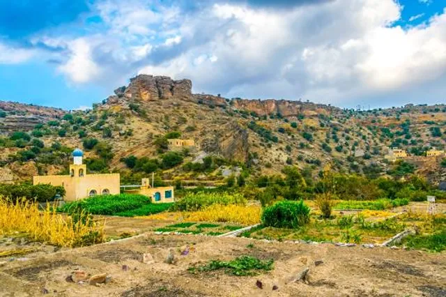
Good place The Jebel Akhar, Jabal Akhdar or Al Jabal Al Akhdar(Arabic: الجبل الأخضر‎ meaning "the Green Mountain"), is part of the Al Hajar Mountains range in Ad Dakhiliyah Governorate of Oman. It extends about 300 km (186 mi) northwest to southeast, between 50–100 km (31–62 mi) inland from the Gulf of Oman coast, and is one of Oman’s most spectacular areas. The highest point, Jebel Shams (Mountain of the Sun), is around 3,000 metres (around 9,800 feet) high.

This mostly limestone1] mountain is the highest point in Oman and the whole of eastern Arabia. Jebel Akhdar forms the central section of the Al Hajar Mountainsrange, and is located around 150 km (93 mi) from Muscat. The range is mostly desert, but at higher altitudes receives around 300 mm (12 in) of precipitation annually — moist enough to allow the growth of shrubs and trees and support agriculture.[2] It is this that gives the mountains their "green" name. An old stronghold on the inland side of the mountain is Birkat al-Mawz, or Pool of the Plantains, with a layout similar to the nearby Jabrin palace. "Poised across the yawning mouth of a great pass into the mountains, Birkat al-Mawz was one of the fortresses of the Bani Riyam tribe which controlled the mountain heartland. Collapsing into ruin until recently, the mud-brick fortress and its painted ceilings are now well on the way to restoration."[5]

The area is about a 45-minute drive from Nizwa and is known for its traditional rose water extraction[6 and agricultural products including pomegranates, walnuts, apricots, black grapes and peaches.[8] It is also the site of honey bee breeding for much of Oman.[9]Agricultural production is improved by the use of Aflajirrigation channels and their associated terraces system devised by the local farmers, who have lived on this mountain for hundreds of years.[10] The Jebel is mostly inhabited by the ancient Arab tribe Bani Riyam (al Riyamy).[11] Most descendants of the tribe are now in the four nearby villages, including Nizwa, Izki and Ibra.[12]

Between 1954 and 1959, the area became a site of the Jebel Akhdar War, a conflict between Omani forcesloyal to the sultan of Oman (aided by British soldiers, including the Special Air Service) and Saudi Arabian-backed rebel forces of the inland Imamate of Oman.[13]

In August 2011, Sultan Qaboos designated Jebel Akhdar a nature reserve in a bid to conserve its unique yet fragile biodiversity. A decree issued by Sultan Qaboos established the ‘Jebel Akhdar Sanctuary for Natural Sceneries.’ The Minister of Environment and Climate Affairs has authority to draft guidelines regulating access and developmental activity within the reserve.[14]

Since 2011, the mountain has featured as the principal climb in the Tour of Oman road bicycle race.[15] In the area, several important rock art sites, with figures dating back to 6000 years ago, have been discovered and...

   Read more
avatar
5.0
1y

The Jebel Akhdar Mountains (Arabic: ٱلْجَبَل ٱلْأَخْضَر, romanized: Al-Jabal Al-Akhḍar, lit. 'The Green Mountain') is a mountain range approximately 80 km (50 mi) long and 32 km (20 mi) wide,2] that is part Hajar Mountains in Ad Dakhiliyah Governorate of Oman. Jebel Akhdar Mountains

Terraces in Jebel Akhdar, 2011 Highest point Elevation 3,018 m (9,902 ft)[1] Coordinates Naming Native name Al-Jabal Al-Akhḍar (ٱلْجَبَل ٱلْأَخْضَر (Arabic)) Geography Jebel Akhdar Mountains is located in OmanJebel Akhdar MountainsJebel Akhdar Mountains Location in Oman Show map of Oman Show map of Middle East Show map of West and Central Asia Show all Location Oman Parent range Al-Hajar Mountains It rises to a height of 3,018 m (9,902 ft)[1 and encompasses the Saiq Plateau at 2,000 m (6,600 ft) above sea level. Jebel Akhdar Mountains is famous for its labyrinth of wadis (river valleys) and terraced orchards, where pomegranates, apricots, and roses grow in abundance due to its mild Mediterranean climate. The highest peak in the Jebel Akhdar Mountains is Jebel Shams,[4] which with its elevation of 3,018 m (9,902 ft) is also the highest peak in the Hajar range and in Oman. Jebel Shams also has a second summit (the South Summit), which is publicly accessible for trekking via the W4 Trail.The elevation of the second south summit is 2,997 m (9,833 ft).

This mostly limestone mountain is one of the highest points in Oman and eastern Arabia. Jebel Akhdar lies at the central section of the Hajar range, located around 150 km (93 mi) from Muscat and accessible only by four-wheel drive.The range is mostly desert, but at higher altitudes receives around 300 mm (12 in) of precipitation annually — moist enough to allow the growth of shrubs and trees and support agriculture.It is this that gives the mountains their "green" name. An old stronghold on the inland side of the mountain is Birkat al-Mawz, or Pool of the Plantains, with a layout similar to the nearby Jabrin palace.

The area is about a 45-minute drive from Nizwa and is known for its traditional rose water extraction and agricultural products including pomegranates, walnuts, apricots, black grapes, and peaches. It is also the site of honey bee breeding for much of Oman.Agricultural production is improved by the use of Falaj irrigation channels and their associated terraces system devised by the local farmers, who have lived on this mountain for hundreds of years. Al Sogara is a historic village carved into the mountainside.The Jebel is mostly inhabited by the ancient Arab tribe Bani Riyam (al Riyamy).Most descendants of the tribe are now in the four nearby villages, including Nizwa,...

   Read more
avatar
5.0
5y

Oman Adventures Club had organised an exhilarating adventure to a place called Masirat Shiraqieen(aka The Lost Village). We arrived at the starting the starting point and after a quick briefing about the hike, we began to descend towards the hidden gem. Although challenging, we continued all the way down. After 3 hours of descending, we reached the foot of the mountains. We rested and energised with fruit and kahwa accompanied with dates. The backdrop of palm trees accompanied with the acoustics of the falaj made for quite a picturesque view. Then it was time for our second challenge... trekking all the way up to the starting point. We paced ourselves all the way through. With Mustafa, Saleh and Badar motivating us to keep going. A huge shout out to Emma for being absolutely amazing. I enjoyed every moment of this adventure with Oman Adventures Club. They are well organised, and incredibly knowledgeable about the hike as well as the surroundings. I highly recommend Oman Adventures Club for a thrill seeking unforgettable adventure. Theyre efficient, affordable,...

   Read more
Page 1 of 7
Previous
Next