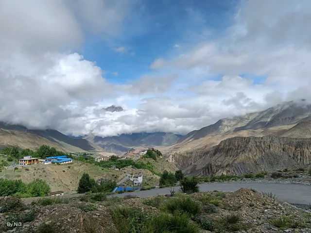
The Gandaki River (also known as the Narayani and the Gandak) is one of the major rivers of Nepal and a left bank tributary of the Ganges in India. In Nepal the river is notable for its deep gorge through the Himalayas.citation needed] It has a total catchment area of 46,300 square kilometers (17,900 sq mi), most of it in Nepal. The basin also contains three of the world's 14 mountains over 8,000 metres (26,000 ft), Dhaulagiri, Manaslu and Annapurna I. Dhaulagiri is the highest point of the Gandaki basin. It lies between the similar Kosi system to the east and the Karnali (Ghaghara) system to the west. The Kali Gandaki river source is at the border with Tibet at an elevation of 6,268 metres (20,564 ft) at the Nhubine Himal Glacier in the Mustang region of Nepal.[1
The headwaters stream on some maps is named the Chhuama Khola and then, nearing Lo Manthang, the Nhichung Khola or Choro Khola. The Kali Gandaki then flows southwest (with the name of Mustang Khola on old, outdated maps) through a sheer-sided, deep canyon before widening at the steel footbridge at Chele, where part of its flow funnels through a rock tunnel, and from this point the now wide river is called the Kali Gandaki on all maps. In Kagbeni a major tributary named Johng Khola, Kak Khola or Krishnaa descends from Muktinath.
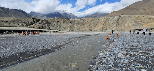
The river then flows southward through a steep gorge known as the Kali Gandaki Gorge, or Andha Galchi, between the mountains Dhaulagiri, elevation 8,167 metres (26,795 ft) to the west and Annapurna I, elevation 8,091 metres (26,545 ft) to the east. If one measures the depth of a canyon by the difference between the river height and the heights of the highest peaks on either side, this gorge is the world's deepest. The portion of the river directly between Dhaulagiri and Annapurna I, 7 kilometres (4 mi) downstream from Tukuche), is at an elevation of 2,520 metres (8,270 ft),[3] which is 5,571 metres (18,278 ft) lower than Annapurna I. The river is older than the Himalayas. As tectonic activity forces the mountains higher, the river has cut through the uplift.
South of the gorge, the river is joined by Rahughat Khola at Galeshwor, Myagdi Khola at Beni, Modi Khola near Kushma and Badigaad at Rudrabeni above Ridi Bazaar. The river then turns east to run along the northern edge of the Mahabharat Range. The largest hydroelectricity project in Nepal is located along this stretch of the river. Turning south again and breaking through the Mahabharats, Kali Gandaki is then joined by a major tributary, the Trishuli, at Devighat, then by the East Rapti River draining the Inner Terai valley known as Chitwan. The Gandaki then crosses the outermost foothills of the Himalayas—Sivalik Hills—into the Terai plains of Nepal. From Devighat, the river flows southwest of Gaindakot town. The river later curves back towards the southeast as it enters India where it is called the Gandak.
Below Gaindakot the river is known as the Narayani or Sapt Gandaki (Seven Gandakis), for seven tributaries rising in the Himalaya or further north along the main Ganges-Brahmaputra divide. These are the Kali Gandaki, the Trishuli River, and the five main tributaries of the Trishuli known as the Daraudi, Seti, Madi,...
Read moreThe river forms a part of the Nepal-India border and then flows into India, where it is called the Gandak. One of the important tributaries of the Ganga, a flash flood if the landslide is swept away would imperil thousands downstream in both countries.
the night of May 23. According to Nepal government officials, no casualty has been reported, but at least 125 people from one of the affected villages have been shifted to a safer place and thousands downstream have been put on alert. Downstream India may also be affected if the landslide is swept away by the weight of the water now accumulating behind it.
“We have issued an alert to people in seven districts downstream as a large volume of water has been accumulated, forming a lake more than two kilometres in length,” said Dinesh Kumar Thapaliya, Western Regional Administrator, Government of Nepal.
According to Thapaliya, many cities and villages downstream are at risk and people have fled to higher altitude to escape a potential flash flood.
The landslide occurred at Kafaldanda area of Ramche village in Myagdi district
The Kali Gandaki joins the Narayani river in southern Nepal and the two together form a part of the Nepal-India border. After that, the river – now called Gandak – flows largely through Bihar before joining the Ganga at Patna.
According to a preliminary estimate, at least four million cusec of water has already accumulated behind the landslide spot. “We have been informed by our security forces that the river has been completely blocked and a huge lake has been formed so the team has been observing the situation and providing information accordingly,” added Thapaliya.
According to a Twitter message by the police in Nepal, the districts placed under alert are Myagdi, Baglung, Parbat, Gulmi, Palpa, Syangja, Tanahu and Nawalparasi. Another tweet by the police says, the lake formed due to the landslide has reached a depth of 150 metres within 12 hours of the landslide, and was already more than a kilometre in length. Local residents said that by mid-morning on May 24, the lake was already three kilometres long.
According to local journalists, a Nepal Army helicopter landed near the landslide spot on May 24 morning, but could not reach the exact location, as rocks were still falling down the slopes in the aftermath of the landslide. Myagdi’s district headquarter Beni – which lies along the river – has been evacuated. Local radio stations have been alerting...
Read moreKaligandaki River also known as Krishna Gandaki is one of the largest branch river of Saptagandaki i.e Narayani. This river originates from Mustang district and flows from Myagdi, some parts of Baglung, Parbat, Tanahu and some other districts of Nepal. Beautiful cities like Lomanthang, Jomsom Beni, Baglung, Kushma, Ridi, Devghat are located in the bank of this river. It is only the river in which sacred stone called Shaligram Shila( which is considered as the symbol of Lord Bishnu in Hinduism) is found. The river has become famous in recent days as many of the tourist places like longest suspension bridge that connects Parbat and Baglung, bunjee jumping station in Kushma etc have developed and operated. Many of the holy places like Khaniyaghat, Tribeni, Devghat etc. Kaligandaki Hydropower 'A' which lies in Mirmi of Syangja district is the biggest hydropower project ever built in this river as well as in Nepal till date. This river makes worlds deepest gorge which lies in between Mt. Dhawalagiri and...
Read more