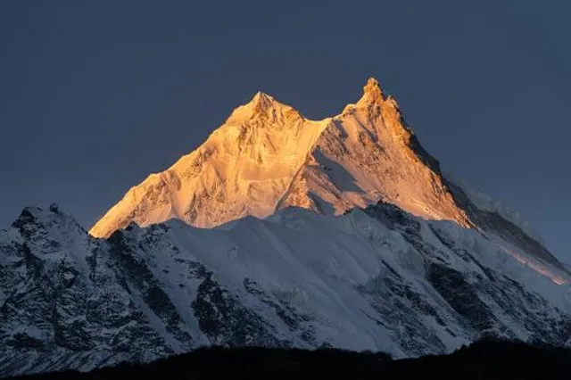
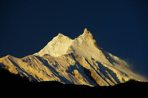
Manaslu (Nepali: मनास्लु, also known as Kutang) is the eighth highest mountain in the world at 8,163 metres (26,781 ft) above sea level. It is located in the Mansiri Himal, part of the Nepalese Himalayas, in the west-central part of Nepal. Its name, which means "mountain of the spirit", comes from the Sanskrit word manasa, meaning "intellect" or "soul". Manaslu was first climbed on May 9, 1956 by Toshio Imanishi and Gyalzen Norbu, members of a Japanese expedition. It is said that "just as the British consider Everest their mountain, Manaslu has always been a Japanese mountain".3
Manaslu Peak 
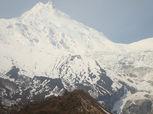
Manaslu is the highest peak in the Gorkha District and is located about 64 km (40 mi) east of Annapurna. The mountain's long ridges and valley glaciers offer feasible approaches from all directions, and culminate in a peak that towers steeply above its surrounding landscape, and is a dominant feature when viewed from afar.56
The Manaslu region offers a variety of trekking options. The popular Manaslu trekking route of 177 kilometres (110 mi), skirts the Manaslu massif over the pass down to Annapurna. The Nepalese Government only permitted trekking of this circuit in 1991.8] The trekking trail follows an ancient salt-trading route along the Burhi Gandak River. En route, 10 peaks over 6,500 metres (21,300 ft) are visible, including a few over 7,000 metres (23,000 ft). The highest point reached along the trek route is the Larkya La at an elevation of 5,106 metres (16,752 ft). As of May 2008, the mountain has been climbed 297 times with 53 fatalities.[910
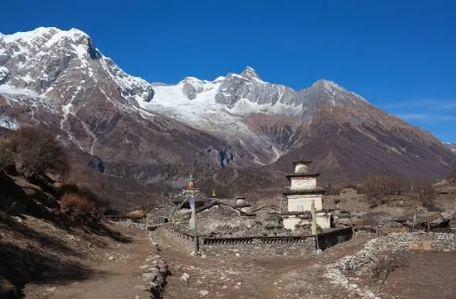
The Manaslu Conservation Area has been established with the primary objective of achieving conservation and sustainable management of the delimited area, which includes Manaslu.Set in the northern Himalayan range in the Gorkha District of Nepal, Manaslu is a serrated "wall of snow and ice hanging in the sky".[citation needed] The three sides of the mountain fall in steps to terraces down below, which are sparsely inhabited with agricultural operations practiced on the land. Apart from climbing Manaslu, trekking is popular in this mountain region, as part of the Manaslu Circuit, a notable path by trekkers in Nepal.[5]
The Manaslu Conservation Area, declared as such in December 1998 under the National Parks and Wild Life Conservation Act, subsumes Manaslu within it. The area covered under the conservation zone is 1,663 square kilometres (642 sq mi) and is managed by the National Trust for Nature Conservation (NTNC) of Nepal. The status of "conservation area" applied to the Manaslu area or region was with the basic objective "To conserve and sustainable management of the natural resources and rich cultural heritage and to promote ecotourism to improve livelihood of the local people in the MCA region."[11]
Manaslu Himal, as it is popularly known among trekkers, provides views of the snow-covered mountains of the Himalayas and allows close interaction with the different ethnic groups who live in hill villages scattered along the trek route.[12]
The trekking route is through mountainous terrain prone to the consequences of monsoon rainfall, land slides and land falls. Encounters with passing yaks, and hypothermia and altitude sickness, are common. Trekking to Manaslu is thus a test...
Read moreManaslu: The Mountain of Spirit
Introduction
-. Manaslu (8,163m) is the eighth-highest mountain in the world. -. Located in the Mansiri Himal range of Nepal, near the Tibetan border. -. Name derived from Manasa (Sanskrit) meaning "intellect" or "soul." -. A quieter alternative to Everest and Annapurna for trekkers and climbers.
Geographic Features
-. Lies in Nepal’s Gorkha District within the Mansiri Himal range. -. Surrounded by deep gorges, glaciers, and steep ridges. -. Source of rivers like Budhi Gandaki, which flows through remote valleys. -. Encompassed by Manaslu Conservation Area (1,663 sq km), rich in biodiversity.
Tourism and Trekking
-. Manaslu Circuit Trek is a popular alternative to the Annapurna Circuit. -. Requires a special trekking permit as it is a restricted area.
Socio-Cultural and Religious Significance
-. Inhabited by ethnic groups such as Gurungs, Tamangs, and Tibetans. -. Influenced by Tibetan Buddhist culture, visible in monasteries and chortens. -. Famous religious sites include Pungyen Gompa and Mu Gompa. -. Annual festivals like Lhosar (Tibetan New Year) celebrated by locals.
Climate Change Impact
-. Retreating glaciers due to rising temperatures. -. Increased risks of avalanches and glacial lake outburst floods. -. Changing weather patterns affecting trekking seasons and local livelihoods. -. Conservation efforts in place to mitigate the impact on biodiversity.
Best Time to Visit
-. Spring (March–May): Clear skies, blooming rhododendrons, stable weather. -. Autumn (September–November): Best visibility, pleasant temperatures, dry trails. -. Winter (December–February): Harsh cold, snowfall, challenging trekking conditions. -. Monsoon (June–August): Heavy rainfall, landslides, and limited visibility.
How to Get There
-. By Road: Kathmandu to Soti Khola (7–9 hours by jeep/bus). -. By Trekking: Soti Khola to Manaslu Circuit (12–16 days trek). -. By Helicopter: Charter flights available for aerial views or emergency evacuations.
Final Thought Manaslu offers stunning landscapes, rich culture, and a challenging trek. Best visited in spring or autumn, it remains a hidden gem. Sustainable tourism is key to...
Read moreManaslu (/məˈnɑːsluː/; Nepali: मनास्लु, also known as Kutang) is the eighth-highest mountain in the world at 8,163 metres (26,781 ft) above sea level. It is in the Mansiri Himal, part of the Nepalese Himalayas, in west-central Nepal. Manaslu means "mountain of the spirit" and the word is derived from the Sanskrit word manasa, meaning "intellect" or "soul". Manaslu was first climbed on May 9, 1956, by Toshio Imanishi and Gyalzen Norbu, members of a Japanese expedition. It is said that, given the many unsuccessful attempts by the British to climb Everest before Nepali Tenzing Norgay and New Zealander Edmund Hillary, "just as the British consider Everest their mountain, Manaslu has always been a Japanese mountain".5
Manaslu Peak Manaslu is the highest peak in the Gorkha District and is about 64 km (40 mi) east of Annapurna, the tenth highest mountain in the world at 8,091 metres (26,545 ft) above sea level. Manaslu's long ridges and valley glaciers offer feasible approaches from all directions and culminate in a peak that towers steeply above its surrounding landscape and is a dominant feature when viewed from afar.78
The Manaslu region offers a variety of trekking options. The popular Manaslu trekking route of 177 kilometres (110 mi) skirts the Manaslu massif over the pass down to Annapurna. The Nepalese Government only permitted trekking on this circuit in 1991.10] The trekking trail follows an ancient salt-trading route along the Budhi Gandaki River. En route, 10 peaks over 6,500 metres (21,325 ft) are visible, including a few over 7,000 metres (22,966 ft). The highest point reached along the trek route is Larkya La at an elevation of 5,106 metres (16,752 ft). As of May 2008, the mountain has been climbed 297 times with 53 fatalities.[1112
The Manaslu Conservation Area Project (MCAP) was established in 1997 with the primary objective of achieving conservation and sustainable management of the delimited area, which also includes Manaslu.[13]
General Set in the northern Himalayan range in the Gorkha District of Nepal, Manaslu is a serrated "wall of snow and ice hanging in the sky".[14] The three sides of the mountain fall in steps to terraces down below, which are sparsely inhabited with agricultural operations practiced on the land. Apart from climbing Manaslu, trekking is popular in this mountain region, as part of the Manaslu Circuit, a notable path for trekkers...
Read more