HTML SitemapExplore

Gaustatoppen — Local services in Tinn

Name
Gaustatoppen
Description
Gaustatoppen is a mountain in Vestfold og Telemark county, Norway. The 1,883-metre tall mountain is located on the south side of the town of Rjukan. It is the tallest mountain in all of Vestfold og Telemark county.
Nearby attractions
Nearby restaurants
Nearby local services
Nearby hotels
Gaustatoppen Turisthytte
3660 Rjukan, Norway
Related posts
Keywords
Gaustatoppen tourism.Gaustatoppen hotels.Gaustatoppen bed and breakfast. flights to Gaustatoppen.Gaustatoppen attractions.Gaustatoppen restaurants.Gaustatoppen local services.Gaustatoppen travel.Gaustatoppen travel guide.Gaustatoppen travel blog.Gaustatoppen pictures.Gaustatoppen photos.Gaustatoppen travel tips.Gaustatoppen maps.Gaustatoppen things to do.
Gaustatoppen things to do, attractions, restaurants, events info and trip planning
Gaustatoppen
NorwayTinnGaustatoppen

Basic Info

Gaustatoppen

3660 Rjukan, Norway
4.8(475)
Save
spot

Ratings & Description

Info

Gaustatoppen is a mountain in Vestfold og Telemark county, Norway. The 1,883-metre tall mountain is located on the south side of the town of Rjukan. It is the tallest mountain in all of Vestfold og Telemark county.

Outdoor
Adventure
Scenic
Family friendly
attractions: , restaurants: , local businesses:
logoLearn more insights from Wanderboat AI.

Plan your stay

hotel
Pet-friendly Hotels in Tinn
Find a cozy hotel nearby and make it a full experience.
hotel
Affordable Hotels in Tinn
Find a cozy hotel nearby and make it a full experience.
hotel
The Coolest Hotels You Haven't Heard Of (Yet)
Find a cozy hotel nearby and make it a full experience.
hotel
Trending Stays Worth the Hype in Tinn
Find a cozy hotel nearby and make it a full experience.

Reviews

Get the Appoverlay
Get the AppOne tap to find yournext favorite spots!
Wanderboat LogoWanderboat

Your everyday Al companion for getaway ideas

CompanyAbout Us
InformationAI Trip PlannerSitemap
SocialXInstagramTiktokLinkedin
LegalTerms of ServicePrivacy Policy

Get the app

© 2025 Wanderboat. All rights reserved.

Reviews of Gaustatoppen

4.8
(475)
avatar
5.0
6y

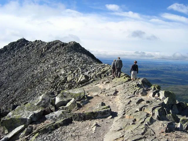
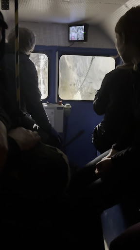
Gaustatoppen (abbreviated as Gausta) is the highest mountain in southern Norway, from where it can be seen furthest in Norway. Since the Romantic era, poets and painters have described it as the most beautiful mountain in the country. The northern slopes of Gausta rise above Rjukan to a height of 1860 meters above sea level. Until the late summer Gausta shows off as a snowy mountain from far away. The slopes may be full of snow till late July. For Norwegians, Gausta is something like Sněžka for Czechs or Rysy for Poles. More than 30,000 people ascend to the top of the mountain every year, and it is the duty of every Norwegian to look at the top at least once in a lifetime. So the track to the top is quite busy on weekends and holidays. Ascent to the top of Gausta is considered one of the TOP trips in Norway. The circular view from the top is the largest view in Norway. From the top of Gausta you can see the entire sixth of Norway and in good visibility, you can see the sea and coast in the south and on the east you can see to Sweden. Near the top, there is the stone hut Gaustatoppen Turisthytta, where you can have some of the tastiest waffles in Norway (they are really delicious, with strawberry or blueberry jam). The chalet is supplied with a cable car inside the mountain (which you can also take to go to the summit, but I hope you are not lazy and you will climb it to the top :-D). On the top you can also find the highest public toilets in Norway. Access to the toilets is only via credit card, and if you do not have a credit card, you can't go there. The coins are useless to you. That is a little bit bizarre to me, but you can't stop the progress. And Norway is trying to be a very modern...

   Read more
avatar
5.0
4y

one of the memorable ski - top touring trips I have ever taken and paradise for freeriders. I advise - gotta be a very good skier to go down, the couloirs are more 40% steep and the recommended marked skier off-piste trail is more or less like steep black. Check the weather and possible avalanche info (yr.no and varsom.no) or just call the Gaustabannen (tramway inside of the mountain). Google it. It took me two hours to get to the top from Gaustabannen car park. You can fill waterbottle in turisthytte on top, but check if they are open or just eat the snow🤣😎! I found it neccesary to have a good food with me. It tired me out and I wanted to be all right before swishing down on skis. it's good to have extra layers or seat pad to sit on on top. Beware of the snow conditions, always check, (best is to call them a day ahead when you are planing to go) have spade, and I made a mistake to not take a ski crampons with me, as it was little skied near the top, therefore ice patches appeared. Also Gaustatoppen is exposed to wind, it is a stand-alone mountain! The price is definitely the view... o don't think it can be put in words....

   Read more
avatar
4.0
6y

The hike took us 4.5 hours but that's because we took it quite slow. It was a cold and windy day and it started to rain periodically. We started from the Starvso parking lot, which is the longer route, instead of next to the Gaustabanan. The route next to the Gaustabanan is shorter, but apparently steeper. However, the longer route has a few considerably steep parts too. Not too demanding, you just need to take it slow. The path is very clearly marked with red Ts, but the path is not a trail it's extremely rocky. This is probably where you need to take it slow to make sure you don't roll an ankle (if you're a bit unco-ordinated like me). When we finally reached the top, it was foggy and we had no view. So we decided to goto the restaurant nearthe top to get ourselves some piping fresh hot waffles only to realise we had left all of our money 6kms away back in the car. Maybe it's the feeling of 'you want what you' cant have', but that feeling of having hot waffles and jam after you've been freezing your butt off in the wind and rain would be just oh-so satisfying. So remember to...

   Read more
Page 1 of 7
Previous
Next

Posts

Maria KuzarMaria Kuzar
Moderately difficult tour, if you read something else it is not true. An easy tour means you don't have to stop. 99.9 percent of you will have to make 2-3 short stops during the roughly 2-2.5 hour hike to the top. So it is really a moderately difficult tour. In case of bad weather, very poor accessibility and you will slip, the terrain can be marked as difficult. If you want to continue from the hut to the top of Gaustatoppen, you have to use your hands, so it is a climbing terrain, difficulty level 1-2 by UIAA - I definitely do not recommend it in the rain. I recommend taking enough water, it cannot be topped up. Time 5.5 hours ascent + descent including rests. We went from Svineroe (8 km). You can park on the side of the road or in a paid parking lot.
Your browser does not support the video tag.
Ewout SchalkwijkEwout Schalkwijk
Meget fin utsikt om du er heldig med været. Alle kan komme seg oppe på toppen med trikken inn i fjellet. Anbefales på det sterkeste å besøke stedet😃👍🏻
Torsten ScheithauerTorsten Scheithauer
Fascinating location! We went in the middle of July and had a big cloud on top of the mountain. Down on the campsite it was warm whereas on the mountain it was cold, so take something warm with you. Also the way up is quite difficult. You definitely need some good hiking shoes since it’s mostly stone on the way. On the way back we decided to take the little train back down which we highly recommend! The story is very interesting and sitting inside is even better. Though you need to walk back to the other parking spot (Gaustaban to Stavsro), depending where you parked. There are at least two hiking routes, the one from the train is quite steep. We choose the other one. Overall great experience!
See more posts
See more posts
hotel
Find your stay

Pet-friendly Hotels in Tinn

Find a cozy hotel nearby and make it a full experience.

Moderately difficult tour, if you read something else it is not true. An easy tour means you don't have to stop. 99.9 percent of you will have to make 2-3 short stops during the roughly 2-2.5 hour hike to the top. So it is really a moderately difficult tour. In case of bad weather, very poor accessibility and you will slip, the terrain can be marked as difficult. If you want to continue from the hut to the top of Gaustatoppen, you have to use your hands, so it is a climbing terrain, difficulty level 1-2 by UIAA - I definitely do not recommend it in the rain. I recommend taking enough water, it cannot be topped up. Time 5.5 hours ascent + descent including rests. We went from Svineroe (8 km). You can park on the side of the road or in a paid parking lot.
Maria Kuzar

Maria Kuzar

hotel
Find your stay

Affordable Hotels in Tinn

Find a cozy hotel nearby and make it a full experience.

Get the Appoverlay
Get the AppOne tap to find yournext favorite spots!
Meget fin utsikt om du er heldig med været. Alle kan komme seg oppe på toppen med trikken inn i fjellet. Anbefales på det sterkeste å besøke stedet😃👍🏻
Ewout Schalkwijk

Ewout Schalkwijk

hotel
Find your stay

The Coolest Hotels You Haven't Heard Of (Yet)

Find a cozy hotel nearby and make it a full experience.

hotel
Find your stay

Trending Stays Worth the Hype in Tinn

Find a cozy hotel nearby and make it a full experience.

Fascinating location! We went in the middle of July and had a big cloud on top of the mountain. Down on the campsite it was warm whereas on the mountain it was cold, so take something warm with you. Also the way up is quite difficult. You definitely need some good hiking shoes since it’s mostly stone on the way. On the way back we decided to take the little train back down which we highly recommend! The story is very interesting and sitting inside is even better. Though you need to walk back to the other parking spot (Gaustaban to Stavsro), depending where you parked. There are at least two hiking routes, the one from the train is quite steep. We choose the other one. Overall great experience!
Torsten Scheithauer

Torsten Scheithauer

See more posts
See more posts