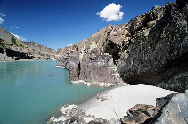
The major cities of the Indus Valley Civilisation, such as Harappa and Mohenjo-daro, date back to around 3300 BC, and represent some of the largest human habitations of the ancient world. The Indus Valley Civilisation extended from across northeast Afghanistan to Pakistan and northwest India,31] with an upward reach from east of Jhelum River to Ropar on the upper Sutlej. The coastal settlements extended from Sutkagan Dor at the Pakistan, Iran border to Kutch in modern Gujarat, India. There is an Indus site on the Amu Darya at Shortughai in northern Afghanistan, and the Indus site Alamgirpur at the Hindon River is located only 28 km (17 mi) from Delhi. To date, over 1,052 cities and settlements have been found, mainly in the general region of the Ghaggar-Hakra River and its tributaries. Among the settlements were the major urban centres of Harappa and Mohenjo-daro, as well as Lothal, Dholavira, Ganeriwala, and Rakhigarhi. Only 40 Indus Valley sites have been discovered on the Indus and its tributaries.[32] However, it is notable that majority of the Indus script seals and inscribed objects discovered were found at sites along the Indus river.[a34]
Most scholars believe that settlements of Gandhara grave culture of the early Indo-Aryans flourished in Gandhara from 1700 BC to 600 BC, when Mohenjo-daro and Harappa had already been abandoned.
The Rigveda describes several rivers, including one named "Sindhu". The Rigvedic "Sindhu" is thought to be the present-day Indus river. It is attested 176 times in its text, 94 times in the plural, and most often used in the generic sense of "river". In the Rigveda, notably in the later hymns, the meaning of the word is narrowed to refer to the Indus river in particular, e.g. in the list of rivers mentioned in the hymn of Nadistuti sukta. The Rigvedic hymns apply a feminine gender to all the rivers mentioned therein, except for the Brahmaputra.
The word "India" is derived from the Indus River. In ancient times, "India" initially referred to those regions immediately along the east bank of the Indus, where are Punjab and Sindh now but by 300 BC, Greek writers including Herodotus and Megasthenes were applying the term to the entire subcontinent that extends much farther eastward.[35
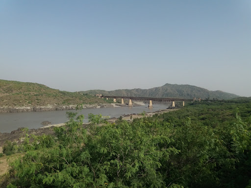
The lower basin of the Indus forms a natural boundary between the Iranian Plateau and the Indian subcontinent; this region embraces all or parts of the Pakistani provinces Balochistan, Khyber Pakhtunkhwa, Punjab and Sindh and the countries Afghanistan and India. The first West Eurasian empire to annex the Indus Valley was the Persian Empire, during the reign of Darius the Great. During his reign, the Greek explorer Scylax of Caryanda was commissioned to explore the course of the Indus. It was crossed by the invading armies of Alexander, but after his Macedonians conquered the west bank—joining it to the Hellenic world, they elected to retreat along the southern course of the river, ending Alexander's Asian campaign. Alexander's admiral Nearchus set out from the Indus Delta to explore the Persian Gulf, until reaching the Tigris River. The Indus Valley was later dominated by the Mauryan and Kushan Empires, Indo-Greek Kingdoms, Indo-Scythians and Hepthalites. Over several centuries Muslim armies of Muhammad ibn al-Qasim, Mahmud of Ghazni, Muhammad of Ghor, Timur and Babur crossed the river to invade Sindh and Punjab, providing a gateway to the Indian...
Read more𝗜 𝗽𝗹𝗮𝗰𝗲 𝗶𝘀 𝘀𝗼 𝗯𝗲𝗮𝘂𝘁𝗶𝗳𝘂𝗹...... 𝗜 𝗹𝗼𝘃𝗲 𝗶𝘁 𝗮 𝗹𝗼𝘁... 𝗜 𝗴𝗶𝘃𝗲 𝘂𝘀 𝗮 𝗜𝗻𝗻𝗲𝗿 𝗽𝗲𝗮𝗰𝗲 𝗧𝗵𝗲 𝘂𝗹𝘁𝗶𝗺𝗮𝘁𝗲 𝘀𝗼𝘂𝗿𝗰𝗲 𝗼𝗳 𝘁𝗵𝗲 𝗜𝗻𝗱𝘂𝘀 𝗶𝘀 𝗼𝗻 𝘁𝗵𝗲 𝗧𝗶𝗯𝗲𝘁𝗮𝗻 𝗽𝗹𝗮𝘁𝗲𝗮𝘂 𝗶𝗻 𝘁𝗵𝗲 𝘃𝗶𝗰𝗶𝗻𝗶𝘁𝘆 𝗼𝗳 𝗟𝗮𝗸𝗲 𝗠𝗮𝗻𝘀𝗮𝗿𝗼𝘃𝗮𝗿; 𝗶𝘁 𝗯𝗲𝗴𝗶𝗻𝘀 𝗮𝘁 𝘁𝗵𝗲 𝗰𝗼𝗻𝗳𝗹𝘂𝗲𝗻𝗰𝗲 𝗼𝗳 𝘁𝗵𝗲 𝗦𝗲𝗻𝗴𝗴𝗲 𝗮𝗻𝗱 𝗚𝗮𝗿 𝗿𝗶𝘃𝗲𝗿𝘀 𝘁𝗵𝗮𝘁 𝗱𝗿𝗮𝗶𝗻 𝘁𝗵𝗲 𝗡𝗴𝗮𝗻𝗴𝗹𝗼𝗻𝗴 𝗞𝗮𝗻𝗴𝗿𝗶 𝗮𝗻𝗱 𝗚𝗮𝗻𝗴𝗱𝗶𝘀𝗲 𝗦𝗵𝗮𝗻 𝗺𝗼𝘂𝗻𝘁𝗮𝗶𝗻 𝗿𝗮𝗻𝗴𝗲𝘀. 𝗧𝗵𝗲 𝗜𝗻𝗱𝘂𝘀 𝘁𝗵𝗲𝗻 𝗳𝗹𝗼𝘄𝘀 𝗻𝗼𝗿𝘁𝗵𝘄𝗲𝘀𝘁 𝘁𝗵𝗿𝗼𝘂𝗴𝗵 𝗹𝗮𝗱𝗮𝗸𝗵-𝗕𝗮𝗹𝘁𝗶𝘀𝘁𝗮𝗻 𝗶𝗻𝘁𝗼 𝗚𝗶𝗹𝗴𝗶𝘁, 𝗷𝘂𝘀𝘁 𝘀𝗼𝘂𝘁𝗵 𝗼𝗳 𝘁𝗵𝗲 𝗞𝗮𝗿𝗮𝗸𝗼𝗿𝗮𝗺 𝗿𝗮𝗻𝗴𝗲. 𝗧𝗵𝗲 𝗦𝗵𝘆𝗼𝗸, 𝗦𝗵𝗶𝗴𝗮𝗿 𝗮𝗻𝗱 𝗚𝗶𝗹𝗴𝗶𝘁 𝘀𝘁𝗿𝗲𝗮𝗺𝘀 𝗰𝗮𝗿𝗿𝘆 𝗴𝗹𝗮𝗰𝗶𝗮𝗹 𝘄𝗮𝘁𝗲𝗿𝘀 𝗶𝗻𝘁𝗼 𝘁𝗵𝗲 𝗺𝗮𝗶𝗻 𝗿𝗶𝘃𝗲𝗿. 𝗜𝘁 𝗴𝗿𝗮𝗱𝘂𝗮𝗹𝗹𝘆 𝗯𝗲𝗻𝗱𝘀 𝘁𝗼 𝘁𝗵𝗲 𝘀𝗼𝘂𝘁𝗵, 𝗰𝗼𝗺𝗶𝗻𝗴 𝗼𝘂𝘁 𝗼𝗳 𝘁𝗵𝗲 𝗵𝗶𝗹𝗹𝘀 𝗯𝗲𝘁𝘄𝗲𝗲𝗻 𝗣𝗲𝘀𝗵𝗮𝘄𝗮𝗿 𝗮𝗻𝗱 𝗥𝗮𝘄𝗮𝗹𝗽𝗶𝗻𝗱𝗶. 𝗧𝗵𝗲 𝗜𝗻𝗱𝘂𝘀 𝗽𝗮𝘀𝘀𝗲𝘀 𝗴𝗶𝗴𝗮𝗻𝘁𝗶𝗰 𝗴𝗼𝗿𝗴𝗲𝘀 4500 - 5200 𝗺𝗲𝘁𝗲𝗿𝘀 (15,000-17,000 𝗳𝗲𝗲𝘁) 𝗵𝗶𝗴𝗵 𝗻𝗲𝗮𝗿 𝘁𝗵𝗲 𝗡𝗮𝗻𝗴𝗮 𝗣𝗮𝗿𝗯𝗮𝘁 𝗺𝗮𝘀𝘀𝗶𝗳. 𝗜𝘁 𝘀𝘄𝗶𝗳𝘁𝗹𝘆 𝗳𝗹𝗼𝘄𝘀 𝗮𝗰𝗿𝗼𝘀𝘀 𝗛𝗮𝘇𝗮𝗿𝗮, 𝗮𝗻𝗱 𝗶𝘀 𝗱𝗮𝗺𝗺𝗲𝗱 𝗮𝘁 𝘁𝗵𝗲 𝗧𝗮𝗿𝗯𝗲𝗹𝗮 𝗥𝗲𝘀𝗲𝗿𝘃𝗼𝗶𝗿. 𝗧𝗵𝗲 𝗞𝗮𝗯𝘂𝗹 𝗥𝗶𝘃𝗲𝗿 𝗷𝗼𝗶𝗻𝘀 𝗶𝘁 𝗻𝗲𝗮𝗿 𝗔𝘁𝘁𝗼𝗰𝗸. 𝗧𝗵𝗲 𝗿𝗲𝗺𝗮𝗶𝗻𝗱𝗲𝗿 𝗼𝗳 𝗶𝘁𝘀 𝗿𝗼𝘂𝘁𝗲 𝘁𝗼 𝘁𝗵𝗲 𝘀𝗲𝗮 𝗶𝘀 𝗶𝗻 𝗽𝗹𝗮𝗶𝗻𝘀 𝗼𝗳 𝘁𝗵𝗲 𝗣𝘂𝗻𝗷𝗮𝗯 𝗮𝗻𝗱 𝗦𝗶𝗻𝗱, 𝘄𝗵𝗲𝗿𝗲 𝘁𝗵𝗲 𝗿𝗶𝘃𝗲𝗿 𝗯𝗲𝗰𝗼𝗺𝗲𝘀 𝘀𝗹𝗼𝘄-𝗳𝗹𝗼𝘄𝗶𝗻𝗴 𝗮𝗻𝗱 𝗵𝗶𝗴𝗵𝗹𝘆 𝗯𝗿𝗮𝗶𝗱𝗲𝗱. 𝗜𝘁 𝗶𝘀 𝗷𝗼𝗶𝗻𝗲𝗱 𝗯𝘆 𝗣𝗮𝗻𝗷𝗻𝗮𝗱 𝗥𝗶𝘃𝗲𝗿 𝗮𝘁 𝗠𝗶𝘁𝗵𝗮𝗻𝗸𝗼𝘁. 𝗕𝗲𝘆𝗼𝗻𝗱 𝘁𝗵𝗶𝘀 𝗰𝗼𝗻𝗳𝗹𝘂𝗲𝗻𝗰𝗲, 𝘁𝗵𝗲 𝗿𝗶𝘃𝗲𝗿, 𝗮𝘁 𝗼𝗻𝗲 𝘁𝗶𝗺𝗲, 𝘄𝗮𝘀 𝗻𝗮𝗺𝗲𝗱 𝘁𝗵𝗲 𝗦𝗮𝘁𝗻𝗮𝗱 𝗥𝗶𝘃𝗲𝗿 (𝘀𝗮𝘁 = 𝘀𝗲𝘃𝗲𝗻, 𝗻𝗮𝗱𝗶 = 𝗿𝗶𝘃𝗲𝗿) 𝗮𝘀 𝘁𝗵𝗲 𝗿𝗶𝘃𝗲𝗿 𝘄𝗮𝘀 𝗻𝗼𝘄 𝗰𝗮𝗿𝗿𝘆𝗶𝗻𝗴 𝘁𝗵𝗲 𝘄𝗮𝘁𝗲𝗿𝘀 𝗼𝗳 𝗞𝗮𝗯𝘂𝗹 𝗥𝗶𝘃𝗲𝗿, 𝗜𝗻𝗱𝘂𝘀 𝗥𝗶𝘃𝗲𝗿 𝗮𝗻𝗱 𝘁𝗵𝗲 𝗳𝗶𝘃𝗲 𝗣𝘂𝗻𝗷𝗮𝗯 𝗿𝗶𝘃𝗲𝗿𝘀. 𝗣𝗮𝘀𝘀𝗶𝗻𝗴 𝗯𝘆 𝗝𝗮𝗺𝘀𝗵𝗼𝗿𝗼, 𝗶𝘁 𝗲𝗻𝗱𝘀 𝗶𝗻 𝗮 𝗹𝗮𝗿𝗴𝗲 𝗱𝗲𝗹𝘁𝗮 𝘁𝗼 𝘁𝗵𝗲 𝗲𝗮𝘀𝘁 𝗼𝗳 𝗧𝗵𝗮𝘁𝘁𝗮, 𝗻𝗲𝗮𝗿 𝗣𝗮𝗸𝗶𝘀𝘁𝗮𝗻'𝘀 𝗽𝗼𝗿𝘁 𝗰𝗶𝘁𝘆, 𝗞𝗮𝗿𝗮𝗰𝗵𝗶 . 𝗧𝗵𝗲 𝘁𝗼𝘁𝗮𝗹 𝗹𝗲𝗻𝗴𝘁𝗵 𝗼𝗳 𝘁𝗵𝗲 𝗿𝗶𝘃𝗲𝗿 𝗶𝘀 3200 𝗸𝗶𝗹𝗼𝗺𝗲𝘁𝗲𝗿𝘀 (2000 𝗺𝗶𝗹𝗲𝘀). 𝗧𝗵𝗲 𝗿𝗶𝘃𝗲𝗿 𝗵𝗮𝘀 𝗮 𝘁𝗼𝘁𝗮𝗹 𝗱𝗿𝗮𝗶𝗻𝗮𝗴𝗲 𝗮𝗿𝗲𝗮 𝗲𝘅𝗰𝗲𝗲𝗱𝗶𝗻𝗴 1,165,000 𝘀𝗾𝘂𝗮𝗿𝗲 𝗸𝗶𝗹𝗼𝗺𝗲𝘁𝗲𝗿𝘀 (450,000 𝘀𝗾𝘂𝗮𝗿𝗲 𝗺𝗶𝗹𝗲𝘀). 𝗜𝘁𝘀 𝗲𝘀𝘁𝗶𝗺𝗮𝘁𝗲𝗱 𝗮𝗻𝗻𝘂𝗮𝗹 𝗳𝗹𝗼𝘄 𝘀𝘁𝗮𝗻𝗱𝘀 𝗮𝘁 𝗮𝗿𝗼𝘂𝗻𝗱 207 𝗰𝘂𝗯𝗶𝗰 𝗸𝗶𝗹𝗼𝗺𝗲𝘁𝗲𝗿𝘀. 𝗕𝗲𝗴𝗶𝗻𝗻𝗶𝗻𝗴 𝗮𝘁 𝘁𝗵𝗲 𝗵𝗲𝗶𝗴𝗵𝘁𝘀 𝗼𝗳 𝘁𝗵𝗲 𝘄𝗼𝗿𝗹𝗱 𝘄𝗶𝘁𝗵 𝗴𝗹𝗮𝗰𝗶𝗲𝗿 , 𝘁𝗵𝗲 𝗿𝗶𝘃𝗲𝗿 𝗳𝗲𝗲𝗱𝘀 𝘁𝗵𝗲 𝗲𝗰𝗼𝘀𝘆𝘀𝘁𝗲𝗺 𝗼𝗳 𝘁𝗲𝗺𝗽𝗲𝗿𝗮𝘁𝗲 𝗳𝗼𝗿𝗲𝘀𝘁𝘀, 𝗽𝗹𝗮𝗶𝗻𝘀 𝗮𝗻𝗱 𝗮𝗿𝗶𝗱 𝗰𝗼𝘂𝗻𝘁𝗿𝘆𝘀𝗶𝗱𝗲. 𝗧𝗼𝗴𝗲𝘁𝗵𝗲𝗿 𝘄𝗶𝘁𝗵 𝘁𝗵𝗲 𝗿𝗶𝘃𝗲𝗿𝘀 𝗖𝗵𝗲𝗻𝗮𝗯, 𝗥𝗮𝘃𝗶, 𝗦𝘂𝘁𝗹𝗲𝗷, 𝗝𝗵𝗲𝗹𝘂𝗺, 𝗕𝗲𝗮𝘀 𝗮𝗻𝗱 𝘁𝗵𝗲 𝗲𝘅𝘁𝗶𝗻𝗰𝘁 𝗦𝗮𝗿𝗮𝘀𝘃𝗮𝘁𝗶 𝗥𝗶𝘃𝗲𝗿, 𝘁𝗵𝗲 𝗜𝗻𝗱𝘂𝘀 𝗳𝗼𝗿𝗺𝘀 𝘁𝗵𝗲 𝗦𝗮𝗽𝘁𝗮 𝗦𝗶𝗻𝗱𝗵𝘂 ("𝗦𝗲𝘃𝗲𝗻 𝗥𝗶𝘃𝗲𝗿𝘀") 𝗱𝗲𝗹𝘁𝗮 𝗶𝗻 𝘁𝗵𝗲 𝗦𝗶𝗻𝗱𝗵 𝗽𝗿𝗼𝘃𝗶𝗻𝗰𝗲 𝗼𝗳 𝗣𝗮𝗸𝗶𝘀𝘁𝗮𝗻. 𝗜𝘁 𝗵𝗮𝘀 20 𝗺𝗮𝗷𝗼𝗿...
Read moreI place is so beautiful...... I love it a lot... I give us a Inner peace The ultimate source of the Indus is on the Tibetan plateau in the vicinity of Lake Mansarovar; it begins at the confluence of the Sengge and Gar rivers that drain the Nganglong Kangri and Gangdise Shan mountain ranges. The Indus then flows northwest through ladakh-Baltistan into Gilgit, just south of the Karakoram range. The Shyok, Shigar and Gilgit streams carry glacial waters into the main river. It gradually bends to the south, coming out of the hills between Peshawar and Rawalpindi. The Indus passes gigantic gorges 4500 - 5200 meters (15,000-17,000 feet) high near the Nanga Parbat massif. It swiftly flows across Hazara, and is dammed at the Tarbela Reservoir. The Kabul River joins it near Attock. The remainder of its route to the sea is in plains of the Punjab and Sind, where the river becomes slow-flowing and highly braided. It is joined by Panjnad River at Mithankot. Beyond this confluence, the river, at one time, was named the Satnad River (sat = seven, nadi = river) as the river was now carrying the waters of Kabul River, Indus River and the five Punjab rivers. Passing by Jamshoro, it ends in a large delta to the east of Thatta, near Pakistan's port city, Karachi . The total length of the river is 3200 kilometers (2000 miles). The river has a total drainage area exceeding 1,165,000 square kilometers (450,000 square miles). Its estimated annual flow stands at around 207 cubic kilometers. Beginning at the heights of the world with glacier , the river feeds the ecosystem of temperate forests, plains and arid countryside. Together with the rivers Chenab, Ravi, Sutlej, Jhelum, Beas and the extinct Sarasvati River, the Indus forms the Sapta Sindhu ("Seven Rivers") delta in the Sindh province of Pakistan. It has 20 major...
Read more