K2 Mountain Hiking is a challenging yet rewarding adventure also known as Mount Godwin-Austen, is the second-highest mountain in the world, standing at 8,611 meters (28,251 feet). Located on the border between Pakistan and China, it is one of the most iconic and formidable peaks for mountaineers to conquer. Hiking or climbing K2 is no ordinary feat—it requires exceptional physical strength, mental resilience, and a deep understanding of mountaineering. While the hike to K2’s base camp is a popular adventure, the summit remains an extremely dangerous goal for only the most experienced climbers.
-Hiking to K2 Base Camp For those who embark on the journey to K2 Base Camp (often referred to as the "K2 trek"), the adventure starts in the remote northern region of Pakistan, from the town of Skardu. The trek typically spans about 10-12 days, depending on pace, and offers stunning views of some of the world’s highest peaks, including K2 itself. The trek passes through lush valleys, rivers, and alpine meadows before reaching the base camp, situated at an altitude of around 5,150 meters (16,896 feet). While the trek to Base Camp is challenging due to the high altitude and harsh weather conditions, it is considered achievable for most experienced trekkers. The physical demands include long days of hiking, dealing with altitude sickness, and braving unpredictable weather, but for many, reaching Base Camp is the culmination of a dream—a rare chance to stand at the foot of one of the most majestic mountains on Earth.
-Warning at the Summit: Extreme Challenges However, for those aiming for the summit, the challenges increase exponentially. K2 is notorious for its difficult climbing conditions, often referred to as the “Savage Mountain” due to the high number of fatalities associated with summit attempts. Reaching the summit of K2 is considered one of the most dangerous feats in mountaineering, with a fatality rate of around 25% for those who attempt to summit. The mountain is not only physically demanding but also presents unpredictable and severe weather conditions, including blizzards, high winds, and freezing temperatures. The technical challenges of the summit, such as steep ice and rock climbing, combined with the risk of avalanches and falling ice, make the final ascent incredibly dangerous. The infamous “Death Zone” above 8,000 meters, where the oxygen levels are extremely low, presents significant risks to climbers, making summit attempts even more perilous.
-The Importance of Warning Systems Given these extreme risks, it is essential for mountaineers to heed all warnings at the summit and take appropriate measures to ensure their safety. Most climbing expeditions to K2 are accompanied by guides, sherpas, and support teams who monitor the weather and provide crucial advice on when to attempt the summit. The descent is just as treacherous, with the risk of exhaustion, frostbite, and accidents significantly higher at such high altitudes. Moreover, the challenges don’t end at the summit—climbers face life-threatening conditions in the way back down, where high winds, lack of oxygen, and physical exhaustion can cause deadly accidents.
While the trek to K2 Base Camp is an achievable goal for adventurous trekkers with a passion for high-altitude landscapes, attempting to summit K2 is reserved for highly skilled and experienced mountaineers. The mountain’s extreme weather, technical challenges, and high altitude present significant risks to climbers, with warnings at the summit reminding all who attempt the climb of the perilous nature of the endeavor. The journey to the summit of K2 is not just about reaching the top, but about surviving the challenges along the way and understanding the risks involved in such a monumental achievement.
For those who choose to take on this awe-inspiring challenge, it is essential to be prepared, respect the mountain, and always prioritize...
Read moreK2 (Urdu: کے ٹو, Kai Ṭū), also known as Mount Godwin-Austen or Chhogori (Balti and Urdu: چھوغوری, Chinese: 乔戈里峰),[3] at 8,611 metres (28,251 ft) above sea level, is the second highest mountain in the world, after Mount Everest at 8,848 metres (29,029 ft). It is located on the China–Pakistan borderbetween Baltistan in the Gilgit-Baltistan region of northern Pakistan, and the Taxkorgan Tajik Autonomous County of Xinjiang, China.[4] K2 is the highest point of the Karakoram range and the highest point in both
Highest pointElevation8,611 metres (28,251 ft) Ranked 2ndProminence4,020 m (13,190 ft) [1] Ranked 22ndIsolation1,316 kilometres (818 mi)ListingEight-thousander Country high points Seven Second Summits UltraCoordinates35°52′57″N 76°30′48″E [2]NamingNative name
Location of K2
Show map of PakistanShow map of Gilgit BaltistanShow map of XinjiangShow map of AsiaShow all
LocationBaltistan, Gilgit–Baltistan, Pakistan Tashkurgan, Xinjiang, China, China–Pakistan borderCountryPakistanParent rangeKarakoramClimbingFirst ascent31 July 1954 Achille Compagnoni Lino LacedelliEasiest routeAbruzzi Spur
K2 is knownas the Savage Mountaindue to the extreme difficulty of ascent. It has the second-highest fatality rate among the eight-thousanders, with around 300 successful summits and 77 fatalities; about one person dies on the mountain for every four who reach the summit. It is more difficult and hazardous to reach the peak of K2 from the Chinese side, so it is usually climbed from the Pakistani side. K2 has never been climbed during winter, unlike Annapurna, the mountain with the highest fatality-to-summit rate (191 summits and 61 fatalities), or the other eight-thousanders. Ascents have almost always been made in July and August, the warmest times of year; K2's more northern location makes it more susceptible to inclement and colder weather.
The summit was reached for the first time by the Italian climbers Lino Lacedelli and Achille Compagnoni, on the 1954 Italian Karakoram expedition led by Ardito Desio.
Montgomerie's original sketch in which he applied the notation K2
The name K2 is derived from the notation used by the Great Trigonometrical Survey of British India. Thomas Montgomerie made the first survey of the Karakoram from Mount Haramukh, some 210 km (130 miles) to the south, and sketched the two most prominent peaks, labeling them K1 and K2
The policy of the Great Trigonometrical Survey was to use local names for mountains wherever possible] and K1 was found to be known locally as Masherbrum. K2, however, appeared not to have acquired a local name, possibly due to its remoteness. The mountain is not visible from Askole, the last village to the south, or from the nearest habitation to the north, and is only fleetingly glimpsed from the end of the Baltoro Glacier, beyond which few local people would have ventured.The name Chogori, derived from two Balti words, chhogo ("big") and ri ("mountain") ]has been suggested as a local name,but evidence for its widespread use is scant. It may have been a compound name invented by Western explorersor simply a bemused reply to the question "What's that called?" It does, however, form the basis for the name Qogir (simplified Chinese: 乔戈里峰; traditional Chinese: 喬戈里峰; pinyin: Qiáogēlǐ Fēng) by which Chinese authorities officially refer to the peak. Other local names have been suggested including Lamba Pahar ("Tall Mountain" in Urdu) and Dapsang, but are not widely used.
With the mountain lacking a local name, the name Mount Godwin-Austen was suggested, in honor of Henry Godwin-Austen, an early explorer of the area. While the name was rejected by the Royal Geographical Society,it was used on several maps and continues to be used occasionally.
The surveyor's mark, K2, therefore continues to be the name by which the mountain is commonly known. It is now also used in the Balti...
Read moreClimbing
JOIN NOW SIGN IN
YOSEMITE
RED RIVER GORGE
SMITH ROCK
BOULDER
RED ROCK
INDIAN CREEK
JOSHUA TREE
THE GUNKS
Places

PLACES
Is K2, the “Savage Mountain,” Becoming Less Savage?
The world’s second highest peak remains much more difficult and dangerous than Everest, but it’s rapidly commercializing.
AUGUST 17, 2022OWEN CLARKE
Heading out the door? Read this article on the new Outside+ app available now on iOS devices for members! Download the app.
This article is part of Climbing’s online archives documenting climbing’s greatest mountains, such as Everest, and its pioneering practitioners such as Marc-Andre Leclerc.
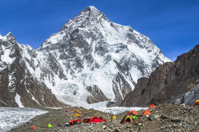
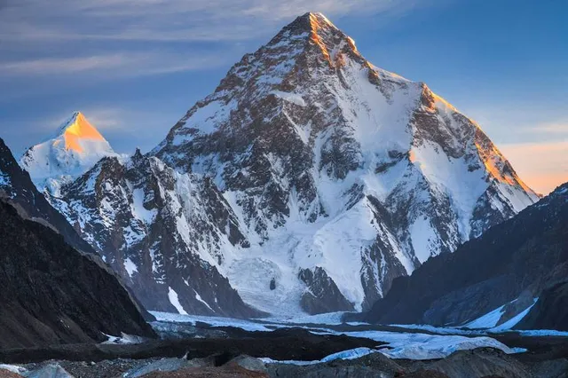
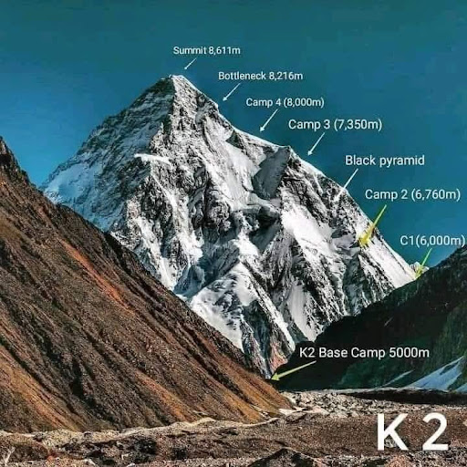
K2 (8,611 meters/28,251 feet), or “Chogori,” is the world’s second highest mountain, after Everest (8,048 meters). Unlike Everest and the eight other highest mountains on Earth, K2 is not located in the Himalaya, however, but in Pakistan’s Karakorum. K2 is situated on the border of the Pakistani-Kashmir region Gilgit-Baltistan, and a slice of Kashmir administered by China as part of Xinjiang. All 14 of the world’s 8,000-meter peaks, and the vast majority of the 100 highest mountains on the planet, are located in either the Karakorum or Himalaya.
Also known as the “Savage Mountain,” K2 is generally considered among the most difficult of the world’s 8,000ers, and its death rate was historically one of the highest of all 14 mountains, along with Annapurna I (8,091 meters) and Nanga Parbat (8,126 meters). The former sits at a death rate of approximately 25%, while Parbat and K2 have traditionally held death rates in the low 20 percents. However, swarms of K2 ascents in recent years, notably in 2022, are contributing to lowering the K2’s overall death rate, which currently sits around 13%. K2 was the last of the 8,000-meter peaks to see a winter ascent (in 2021).
While its difficulty and technicality have traditionally deterred the swarms of amateur mountaineers that flock to Everest, K2 has rapidly commercialized in recent years. Overcrowding on the peak is becoming a concern, especially due to dangerous sections that lend themselves to traffic jams, like the Bottleneck Couloir (see below).
2022 saw over 190 summits as of July 30, smashing the previous yearly record of 62 [2018] by over three times. In addition, over 145 climbers summited in a single 24-hour period, on July 22. “The Everest model is now official on K2,” Himalayan chronicle Alan Arnette wrote in a July 2022 blog. “I [once] wrote that K2 would never become Everest … I was wrong.”
The world’s 10 highest mountains. Everest, K2, Kangchenjunga, Makalu, Lhotse, Manaslu, Dhaulagiri I, Nanga Parbat, Annapurna I, and Cho Oyu. (Illustration: Getty Photo)
History
K2 was originally surveyed by a British team in 1856, christened K2 as it was the second main peak of the Karakorum that was mapped. The other principal Karakakorum summits were originally named likewise (K1, K3, K4, and K5), but today are known as Masherbrum (7,821 meters), Gasherbrum IV (7,925 meters), Gasherbrum II (8,035 meters), and Gasherbrum I...
Read more