HTML SitemapExplore

Great Western Mountain — Local services in Central Province

Name
Great Western Mountain
Description
Great Western Mountain is the 8th highest mountain in Sri Lanka. It is located in Nuwara Eliya District. Its trail is ranked as difficult due to its steep incline and difficult, unclear path.
Nearby attractions
Nearby restaurants
Nearby local services
Nearby hotels
Related posts
Keywords
Great Western Mountain tourism.Great Western Mountain hotels.Great Western Mountain bed and breakfast. flights to Great Western Mountain.Great Western Mountain attractions.Great Western Mountain restaurants.Great Western Mountain local services.Great Western Mountain travel.Great Western Mountain travel guide.Great Western Mountain travel blog.Great Western Mountain pictures.Great Western Mountain photos.Great Western Mountain travel tips.Great Western Mountain maps.Great Western Mountain things to do.
Great Western Mountain things to do, attractions, restaurants, events info and trip planning
Great Western Mountain
Sri LankaCentral ProvinceGreat Western Mountain

Basic Info

Great Western Mountain

Sri Lanka
4.7(71)
Save
spot

Ratings & Description

Info

Great Western Mountain is the 8th highest mountain in Sri Lanka. It is located in Nuwara Eliya District. Its trail is ranked as difficult due to its steep incline and difficult, unclear path.

Outdoor
Adventure
Scenic
Off the beaten path
attractions: , restaurants: , local businesses:
logoLearn more insights from Wanderboat AI.

Plan your stay

hotel
Pet-friendly Hotels in Central Province
Find a cozy hotel nearby and make it a full experience.
hotel
Affordable Hotels in Central Province
Find a cozy hotel nearby and make it a full experience.
hotel
The Coolest Hotels You Haven't Heard Of (Yet)
Find a cozy hotel nearby and make it a full experience.
hotel
Trending Stays Worth the Hype in Central Province
Find a cozy hotel nearby and make it a full experience.

Reviews

Live events

Explore tea fields
Explore tea fields
Mon, Feb 9 • 3:00 PM
Norwood, Central Province 22058, Sri Lanka
View details
Nuwara Eliya to Kandy: Ultimate Hill Country tour
Sun, Feb 8 • 10:00 AM
Nuwara Eliya, Central Province 22150, Sri Lanka
View details
Cooking classes for tourists - Green Villa
Sun, Feb 8 • 4:30 PM
Nuwara Eliya, Central Province 22000, Sri Lanka
View details
Get the Appoverlay
Get the AppOne tap to find yournext favorite spots!
Wanderboat LogoWanderboat

Your everyday Al companion for getaway ideas

CompanyAbout Us
InformationAI Trip PlannerSitemap
SocialXInstagramTiktokLinkedin
LegalTerms of ServicePrivacy Policy

Get the app

© 2025 Wanderboat. All rights reserved.

Posts

tishan madhubhashiyetishan madhubhashiye
Great hiking experience. 🐾️🌾 It is situated at western slope of Nuwara Eliya distric. ⛰️⛰️⛰️ 6th highest mountain (2216m) in Sri Lanka. Tough for beginners but there's a trail for the peak of the mountain and you can ascend easily to the top of mountain. First you have to come to the Great Western Railway Station. 🚉 The name for the mountain "Great Western" is from the Great Western railway station & the Great Western tea estate which are located in front of the mountain. The railway station is 1464m above mean sea level. First you have to walk about 1km from Great Western railway station towards Radella railway station via the railway. 🛤️ Then you'll find a stone staircase to a hindu kovil on your left side. Go through it.There's a small water stream near the kovil. 💦 💦 💦 Turn right from the kovil and you'll find a trail. That's your way. When you reach about 1850m above mean sea level (according to google maps) you'll find  another water stream. Turn right from there. If you have a strong rope it is valuable to your hike. Your ascending pathway to the top via a beautiful forest. 🌱🌳🍃🌿☘️🍀 You can see Piduruthalagala the highest mountain in Sri Lanka, Kikiliyamana, Shanthipura the highest village, Radella, Meepilimana, Conical Hill, Ambewela, Thotupola, Kirigalpoththa, Adam's Peak & Saptha Kanya from the top. There is a camping site at the top of the mountain but no water sourse is there. When you come back there's a fresh & cold water spout. You can have a bath from there. You have to walk another few meters passing the entrance of the kovil, towards Radella railway station via the railway. Railway bridge also there. Great experience for your day today busy life. Come here, enjoy the environment. Feel the natural beauty. Don't ruin it. Don't throw garbage. Don't disturb to the balance of the nature. 🍃🐒🥀🦎🌱
Isuru SenarathnaIsuru Senarathna
6th highest mountain of Sri Lanka (about 2100m msl). Popular among hikers as a scenic destination as well as a camping site. To find the trail need to walk about 800m from the great western station. Near to a bridge on the right side the trail can be seen as a stair to a Kovil. From the kovil the trail runs to the mountaion from the right side of the kovil.The trail identical with a fig tree and a water stream. To reach the top it will take about 3 -4 hours. The upper part of the mountain is a sensitive cloud forest. At 1900m msl there is a another pure water stream and that is the last water stream that can find in the trail. Some areas the slope nearly 75° and need to careful near to cliffs. There are several view points at the top of the mountain and the camping site located near to the last viewpoint. Important *Moderate to Difficult hike. *Ropes may be required(if you are a beginer) **Strongly reccomond to not to go in rainy season. Slopes are deadly **If a begginer a guide reccomond (Mohan the best guide, if need can order food from Mohan - food quality -5 stars/deliciuos😋) **one day hike - yes *birds/frogs/plants observation *forest type -upper montane cloudy forest/top is a dwarf forest *weather -strong winds/misty ****This place still untoched by many humans.So its very cool...please leave only the footprints/nothing else🙏🙏🙏 *if need ask for Mohan's number...
Dashen DissanayakaDashen Dissanayaka
🇱🇰 නානු ඔයට උල්පත් සපයන හත්වෙනි උසම කඳු මුදුන - ග්‍රේට් වෙස්ටර්න් | GREAT WESTERN MOUNTAIN, SRI LANKA. ▪️ •••••••••••••••••••••••••••••••• 👉 දෙස් විදෙස් සංචාරකයන්ගේ නොමද ආකර්ශනය දිනාගත් උඩරට දුම්රිය ගමනේ තවත් එක් මනස්කාන්ත දුම්රිය නැවතුමක් ලෙස ග්‍රේට් වෙස්ටර්න් දුම්රිය නැවතුම්පොළ හැඳින්විය හැක. වටගොඩ සහ රදැල්ල දුම්රිය ස්ථාන අතර පිහිටි මෙම දුම්රිය ස්ථානයේ නම ඇසූ විගස ඇතැම්විට නොදන්නා කෙනෙකුට එය විදේශීය තැනක් යයි සිතෙනු ඇත. නමුත් මෙය ලංකාවේ පිහිටි තවත් එක් සුන්දර ගම්පියසකි. ග්‍රේට් වෙස්ටර්න් දුම්රිය ස්ථානයට පිටුපසින් පතාක යෝධයෙකු සේ නැගී සිටින ලංකාවේ හත්වෙනි උසම කඳු මුදුන ලෙස නම් දරා සිටින, මහවැලි ගඟේ අතු ගංගාවක් වන නානු ඔය සඳහා උල්පත් සපයන, ග්‍රේට් වෙස්ටර්න් කඳු මුදුන මෙම කුඩා ගම්පියස යම්තාක් දුරට හෝ ප්‍රසිද්ධ වීමට එක් හේතුවකි. හැටන්-නුවරඑළිය මාර්ගයේ ගමන් කරන විට මුහුදු මට්ටමේ සිට මීටර් 2212 ක් උසින් පිහිටි මෙම කඳු මුදුන පැහැදිලිව දර්ශනය වේ. මෑත කාලීනව කඳු නගින්නන්ගේ සහ රාත්‍රී කඳවරු ගසන්නන්ගේ ප්‍රචලිත ගමනාන්තයක් වන ග්‍රේට් වෙස්ටර්න් කඳු මුදුන වෙත ගමන් කිරීම ආරම්භ කළ යුත්තේ ග්‍රේට් වෙස්ටර්න් දුම්රිය නැවතුම්පොලෙනි. එම නිසා ග්‍රේට්වෙස්ටර්න් වෙත පැමිණීම සඳහා භාවිතා කළ හැකි යෝග්‍යම ප්‍රවාහන මාධ්‍යය දුම්රිය ලෙස හැඳින්විය හැක. කොළඹින් පිටත්වන බදුල්ල රාත්‍රී තැපල් දුම්රියේ පැමින පාන්දර 3.30ත් 4ත් අතර ග්‍රේට්වෙස්ටර්න් දුම්රිය ස්ථානයෙන් බැසීමට හැකි අතර ඉර උදාවත් සමග ගමන ආරම්භ කළ හැකිය. දුම්රිය ස්ථානයේ සිට රේල් පථය ඔස්සේ දෙපසේ සුන්දර්ත්වය නරඹමින් 2km පමණ ගිය විට කඳු ගැට දෙකක් යා කරමින් සකස් කරන ලද දුම්රිය පාලමක් හමුවන අතර එතනින් වම්පසට වන්නට උඩට ඇදීයන පඩිපෙළක් දැකගත හැකිය. එම පඩිපෙළ දිගේ ඉදිරියට ගිය විට ගම්වැසියන්ගේ කෝවිල හමුවන අතර ඔබ කුමන ආගමක වුවත් ගමන ආරම්භයට පෙර දෑත් එක්කොට වැඳ ගමන ආරම්භ කිරීමට යෝජනා කරමි. කෝවිල පිටුපස වනලැහැබ තුළින් කඳු තරණය ආරම්භ වන අතර එතැන් පටන් කැලේ මැදින් වැටී ඇති අඩි පාරක් ඔස්සේ ඉදිරියට යා යුතුය. අධික තෙත් කලාපීය වනපියසක් වන මෙහි කූඩැල්ලන් නොඅඩුව සිටින බැවින් ඒ සඳහා සූදානම්ව පමිණිය යුතුය. සාම්ප්‍රදායික තෙත් කලාපීය ශාක හා පඳුරු අතරින් ගමන් මාර්ගය ඉදිරියට ඇදෙනවා සේම මීදුම් බර කාළගුණය ක්ෂණික වෙනස්වීම් වලට ලක්වේ. වර්ෂා දිනයකදී නම් නිසැකවම ගමන අසීරු වන අතර අඩිපාර ලිස්සන සුලු වීම නිසා ඇතැම්විට කඹ භාවිතා කිරීමටද සිදුවෙනු ඇත. අඳුරු ගුප්ත පරිසරයත් මීදුම් සහිත වටපිටාවත් පසුකරමින් කිලෝමීටර 4කට ආසන්න දුරක් කඳු තරණය කළ විට මුදුන වෙත ලඟා විය හැක. ආසන්න වශයෙන් ටෙන්ට් හතරකට පමණක් ප්‍රමාණවත් සීමිත ඉඩක් කඳු මුදුනේ තිබෙන බවද කිව යුතුය. පැහැදිලි දිනයකදී ග්‍රේට්වෙස්ටර්න් ගම්පියස, දුම්රිය ස්ථානය, උඩරට දුම්රිය මාර්ගය හා දුම්රිය හුවමාරු වන ආකාරය මෙන්ම සමනළ කඳු මුදුන ඇතුලු කඳු මුදුන් රාශියක් ඇතුලු නෙත් පිණවන මනරම් දර්ශනයක් භුක්ති විඳීමට ග්‍රේට්වෙස්ටර්න් කඳු මුදුනේ සිට ඔබට අවස්ථාව උදාවේ. කඳවරු බැඳීමකින් තොරව වුවද උදෑසන පැමිණ නැවත සවස බදුල්ලෙන් පිටත්වන දුම්රියේ කොළඹ පමිණීමට වුවද මෙම ගමන ඔබට සංවිධානය කරගත හැකිය. ජලය සපයාගැනීමේදී මුදුනට ටික දුරක් පහලින් දිය පහරක් තිබුනද පහළින් තමන්ට අවශ්‍යය ජලය සපයා ගැනීම යෝග්‍යය වේ. සුපුරුදු පරිදි අවසානයේ කිවයුත්තේ මෙම ඡායාරූප වල ඇති සුන්දරත්වය සිය දෑස් වලින්ම විඳීමට ලංකාවේ පුරවැසියෙකු වූ ඔබට අයිතියක් ඇත. එහෙත් එම අයිතිය මෙම සුන්දර පරිසරය විනාශ කිරීම සඳහා අයථා ආයුධයක් ලෙස භාවිතා නොකරන්න. මෙය කාරුණික ඉල්ලීමකි.▪️ ( මේ ගමන යෑම සඳහා මගපෙන්වන්නෙකුගේ විස්තර, අහාර සපයා ගන්නා ආකාරය හා සවිස්තරාත්මක පුද්ගලික අත්දැකීම් ඇතුලත් ලිපියක් ඉදිරියේදී පළකරනු ඇත. 😉 ) - The.Roamer_ ( ඡායාරූප - ඉන්ස්ටග්‍රෑම් ඇසුරෙනි. ) 🔺 ඡායාරූප වල අයිතිය මුල් අයිතිකරුවන් සතුවේ. 🔺 🔸[ සංචාරක අත්දැකීම් හා නිවැරදි තොරතුරු සහ ඡායාරූප සොයා සකස් කරන ලද ලිපියක් වන හෙයින්, අවසරයකින් තොරව කොපි කර පළ කිරීමට පෙර මොහොතක් සිතන්න. ]🔸 ❎ උපුටා ගැනීම තහනම් ❎ 👉 Great Western Mountain is situated in the Nuwara Eliya district. Standing at a height of approximately 2212 m it is the 7th highest mountain in Sri Lanka. Great Western Mountain is difficult hike due to its steep slope and unclear footpath. It is located right behind the Great Western station which is known to be one of the most beautiful railway stations in the central highlands of Sri Lanka, standing approximately 1464 m above sea level. The summit of the mountain provides spectacular views of the surrounding area with glimpses of Pidurutalagala, Sri Pada Holy Mountain and the Seven Virgin Hills. There is also an old Hindu kovil hidden in the forest at this locat
See more posts
See more posts
hotel
Find your stay

Pet-friendly Hotels in Central Province

Find a cozy hotel nearby and make it a full experience.

Great hiking experience. 🐾️🌾 It is situated at western slope of Nuwara Eliya distric. ⛰️⛰️⛰️ 6th highest mountain (2216m) in Sri Lanka. Tough for beginners but there's a trail for the peak of the mountain and you can ascend easily to the top of mountain. First you have to come to the Great Western Railway Station. 🚉 The name for the mountain "Great Western" is from the Great Western railway station & the Great Western tea estate which are located in front of the mountain. The railway station is 1464m above mean sea level. First you have to walk about 1km from Great Western railway station towards Radella railway station via the railway. 🛤️ Then you'll find a stone staircase to a hindu kovil on your left side. Go through it.There's a small water stream near the kovil. 💦 💦 💦 Turn right from the kovil and you'll find a trail. That's your way. When you reach about 1850m above mean sea level (according to google maps) you'll find  another water stream. Turn right from there. If you have a strong rope it is valuable to your hike. Your ascending pathway to the top via a beautiful forest. 🌱🌳🍃🌿☘️🍀 You can see Piduruthalagala the highest mountain in Sri Lanka, Kikiliyamana, Shanthipura the highest village, Radella, Meepilimana, Conical Hill, Ambewela, Thotupola, Kirigalpoththa, Adam's Peak & Saptha Kanya from the top. There is a camping site at the top of the mountain but no water sourse is there. When you come back there's a fresh & cold water spout. You can have a bath from there. You have to walk another few meters passing the entrance of the kovil, towards Radella railway station via the railway. Railway bridge also there. Great experience for your day today busy life. Come here, enjoy the environment. Feel the natural beauty. Don't ruin it. Don't throw garbage. Don't disturb to the balance of the nature. 🍃🐒🥀🦎🌱
tishan madhubhashiye

tishan madhubhashiye

hotel
Find your stay

Affordable Hotels in Central Province

Find a cozy hotel nearby and make it a full experience.

Get the Appoverlay
Get the AppOne tap to find yournext favorite spots!
6th highest mountain of Sri Lanka (about 2100m msl). Popular among hikers as a scenic destination as well as a camping site. To find the trail need to walk about 800m from the great western station. Near to a bridge on the right side the trail can be seen as a stair to a Kovil. From the kovil the trail runs to the mountaion from the right side of the kovil.The trail identical with a fig tree and a water stream. To reach the top it will take about 3 -4 hours. The upper part of the mountain is a sensitive cloud forest. At 1900m msl there is a another pure water stream and that is the last water stream that can find in the trail. Some areas the slope nearly 75° and need to careful near to cliffs. There are several view points at the top of the mountain and the camping site located near to the last viewpoint. Important *Moderate to Difficult hike. *Ropes may be required(if you are a beginer) **Strongly reccomond to not to go in rainy season. Slopes are deadly **If a begginer a guide reccomond (Mohan the best guide, if need can order food from Mohan - food quality -5 stars/deliciuos😋) **one day hike - yes *birds/frogs/plants observation *forest type -upper montane cloudy forest/top is a dwarf forest *weather -strong winds/misty ****This place still untoched by many humans.So its very cool...please leave only the footprints/nothing else🙏🙏🙏 *if need ask for Mohan's number...
Isuru Senarathna

Isuru Senarathna

hotel
Find your stay

The Coolest Hotels You Haven't Heard Of (Yet)

Find a cozy hotel nearby and make it a full experience.

hotel
Find your stay

Trending Stays Worth the Hype in Central Province

Find a cozy hotel nearby and make it a full experience.

🇱🇰 නානු ඔයට උල්පත් සපයන හත්වෙනි උසම කඳු මුදුන - ග්‍රේට් වෙස්ටර්න් | GREAT WESTERN MOUNTAIN, SRI LANKA. ▪️ •••••••••••••••••••••••••••••••• 👉 දෙස් විදෙස් සංචාරකයන්ගේ නොමද ආකර්ශනය දිනාගත් උඩරට දුම්රිය ගමනේ තවත් එක් මනස්කාන්ත දුම්රිය නැවතුමක් ලෙස ග්‍රේට් වෙස්ටර්න් දුම්රිය නැවතුම්පොළ හැඳින්විය හැක. වටගොඩ සහ රදැල්ල දුම්රිය ස්ථාන අතර පිහිටි මෙම දුම්රිය ස්ථානයේ නම ඇසූ විගස ඇතැම්විට නොදන්නා කෙනෙකුට එය විදේශීය තැනක් යයි සිතෙනු ඇත. නමුත් මෙය ලංකාවේ පිහිටි තවත් එක් සුන්දර ගම්පියසකි. ග්‍රේට් වෙස්ටර්න් දුම්රිය ස්ථානයට පිටුපසින් පතාක යෝධයෙකු සේ නැගී සිටින ලංකාවේ හත්වෙනි උසම කඳු මුදුන ලෙස නම් දරා සිටින, මහවැලි ගඟේ අතු ගංගාවක් වන නානු ඔය සඳහා උල්පත් සපයන, ග්‍රේට් වෙස්ටර්න් කඳු මුදුන මෙම කුඩා ගම්පියස යම්තාක් දුරට හෝ ප්‍රසිද්ධ වීමට එක් හේතුවකි. හැටන්-නුවරඑළිය මාර්ගයේ ගමන් කරන විට මුහුදු මට්ටමේ සිට මීටර් 2212 ක් උසින් පිහිටි මෙම කඳු මුදුන පැහැදිලිව දර්ශනය වේ. මෑත කාලීනව කඳු නගින්නන්ගේ සහ රාත්‍රී කඳවරු ගසන්නන්ගේ ප්‍රචලිත ගමනාන්තයක් වන ග්‍රේට් වෙස්ටර්න් කඳු මුදුන වෙත ගමන් කිරීම ආරම්භ කළ යුත්තේ ග්‍රේට් වෙස්ටර්න් දුම්රිය නැවතුම්පොලෙනි. එම නිසා ග්‍රේට්වෙස්ටර්න් වෙත පැමිණීම සඳහා භාවිතා කළ හැකි යෝග්‍යම ප්‍රවාහන මාධ්‍යය දුම්රිය ලෙස හැඳින්විය හැක. කොළඹින් පිටත්වන බදුල්ල රාත්‍රී තැපල් දුම්රියේ පැමින පාන්දර 3.30ත් 4ත් අතර ග්‍රේට්වෙස්ටර්න් දුම්රිය ස්ථානයෙන් බැසීමට හැකි අතර ඉර උදාවත් සමග ගමන ආරම්භ කළ හැකිය. දුම්රිය ස්ථානයේ සිට රේල් පථය ඔස්සේ දෙපසේ සුන්දර්ත්වය නරඹමින් 2km පමණ ගිය විට කඳු ගැට දෙකක් යා කරමින් සකස් කරන ලද දුම්රිය පාලමක් හමුවන අතර එතනින් වම්පසට වන්නට උඩට ඇදීයන පඩිපෙළක් දැකගත හැකිය. එම පඩිපෙළ දිගේ ඉදිරියට ගිය විට ගම්වැසියන්ගේ කෝවිල හමුවන අතර ඔබ කුමන ආගමක වුවත් ගමන ආරම්භයට පෙර දෑත් එක්කොට වැඳ ගමන ආරම්භ කිරීමට යෝජනා කරමි. කෝවිල පිටුපස වනලැහැබ තුළින් කඳු තරණය ආරම්භ වන අතර එතැන් පටන් කැලේ මැදින් වැටී ඇති අඩි පාරක් ඔස්සේ ඉදිරියට යා යුතුය. අධික තෙත් කලාපීය වනපියසක් වන මෙහි කූඩැල්ලන් නොඅඩුව සිටින බැවින් ඒ සඳහා සූදානම්ව පමිණිය යුතුය. සාම්ප්‍රදායික තෙත් කලාපීය ශාක හා පඳුරු අතරින් ගමන් මාර්ගය ඉදිරියට ඇදෙනවා සේම මීදුම් බර කාළගුණය ක්ෂණික වෙනස්වීම් වලට ලක්වේ. වර්ෂා දිනයකදී නම් නිසැකවම ගමන අසීරු වන අතර අඩිපාර ලිස්සන සුලු වීම නිසා ඇතැම්විට කඹ භාවිතා කිරීමටද සිදුවෙනු ඇත. අඳුරු ගුප්ත පරිසරයත් මීදුම් සහිත වටපිටාවත් පසුකරමින් කිලෝමීටර 4කට ආසන්න දුරක් කඳු තරණය කළ විට මුදුන වෙත ලඟා විය හැක. ආසන්න වශයෙන් ටෙන්ට් හතරකට පමණක් ප්‍රමාණවත් සීමිත ඉඩක් කඳු මුදුනේ තිබෙන බවද කිව යුතුය. පැහැදිලි දිනයකදී ග්‍රේට්වෙස්ටර්න් ගම්පියස, දුම්රිය ස්ථානය, උඩරට දුම්රිය මාර්ගය හා දුම්රිය හුවමාරු වන ආකාරය මෙන්ම සමනළ කඳු මුදුන ඇතුලු කඳු මුදුන් රාශියක් ඇතුලු නෙත් පිණවන මනරම් දර්ශනයක් භුක්ති විඳීමට ග්‍රේට්වෙස්ටර්න් කඳු මුදුනේ සිට ඔබට අවස්ථාව උදාවේ. කඳවරු බැඳීමකින් තොරව වුවද උදෑසන පැමිණ නැවත සවස බදුල්ලෙන් පිටත්වන දුම්රියේ කොළඹ පමිණීමට වුවද මෙම ගමන ඔබට සංවිධානය කරගත හැකිය. ජලය සපයාගැනීමේදී මුදුනට ටික දුරක් පහලින් දිය පහරක් තිබුනද පහළින් තමන්ට අවශ්‍යය ජලය සපයා ගැනීම යෝග්‍යය වේ. සුපුරුදු පරිදි අවසානයේ කිවයුත්තේ මෙම ඡායාරූප වල ඇති සුන්දරත්වය සිය දෑස් වලින්ම විඳීමට ලංකාවේ පුරවැසියෙකු වූ ඔබට අයිතියක් ඇත. එහෙත් එම අයිතිය මෙම සුන්දර පරිසරය විනාශ කිරීම සඳහා අයථා ආයුධයක් ලෙස භාවිතා නොකරන්න. මෙය කාරුණික ඉල්ලීමකි.▪️ ( මේ ගමන යෑම සඳහා මගපෙන්වන්නෙකුගේ විස්තර, අහාර සපයා ගන්නා ආකාරය හා සවිස්තරාත්මක පුද්ගලික අත්දැකීම් ඇතුලත් ලිපියක් ඉදිරියේදී පළකරනු ඇත. 😉 ) - The.Roamer_ ( ඡායාරූප - ඉන්ස්ටග්‍රෑම් ඇසුරෙනි. ) 🔺 ඡායාරූප වල අයිතිය මුල් අයිතිකරුවන් සතුවේ. 🔺 🔸[ සංචාරක අත්දැකීම් හා නිවැරදි තොරතුරු සහ ඡායාරූප සොයා සකස් කරන ලද ලිපියක් වන හෙයින්, අවසරයකින් තොරව කොපි කර පළ කිරීමට පෙර මොහොතක් සිතන්න. ]🔸 ❎ උපුටා ගැනීම තහනම් ❎ 👉 Great Western Mountain is situated in the Nuwara Eliya district. Standing at a height of approximately 2212 m it is the 7th highest mountain in Sri Lanka. Great Western Mountain is difficult hike due to its steep slope and unclear footpath. It is located right behind the Great Western station which is known to be one of the most beautiful railway stations in the central highlands of Sri Lanka, standing approximately 1464 m above sea level. The summit of the mountain provides spectacular views of the surrounding area with glimpses of Pidurutalagala, Sri Pada Holy Mountain and the Seven Virgin Hills. There is also an old Hindu kovil hidden in the forest at this locat
Dashen Dissanayaka

Dashen Dissanayaka

See more posts
See more posts

Reviews of Great Western Mountain

4.7
(71)
avatar
5.0
1y

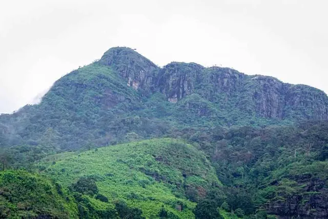
Great Western Mountain is one of the notable peaks in Sri Lanka's central highlands, distinguished by its scenic beauty and biodiversity. Here’s an overview of Great Western Mountain:

Key Facts and Features

Elevation: Great Western Mountain reaches an elevation of approximately 1,800 meters (5,906 feet) above sea level. While not as high as some of the other major peaks in Sri Lanka, it is still a prominent feature of the central highlands.

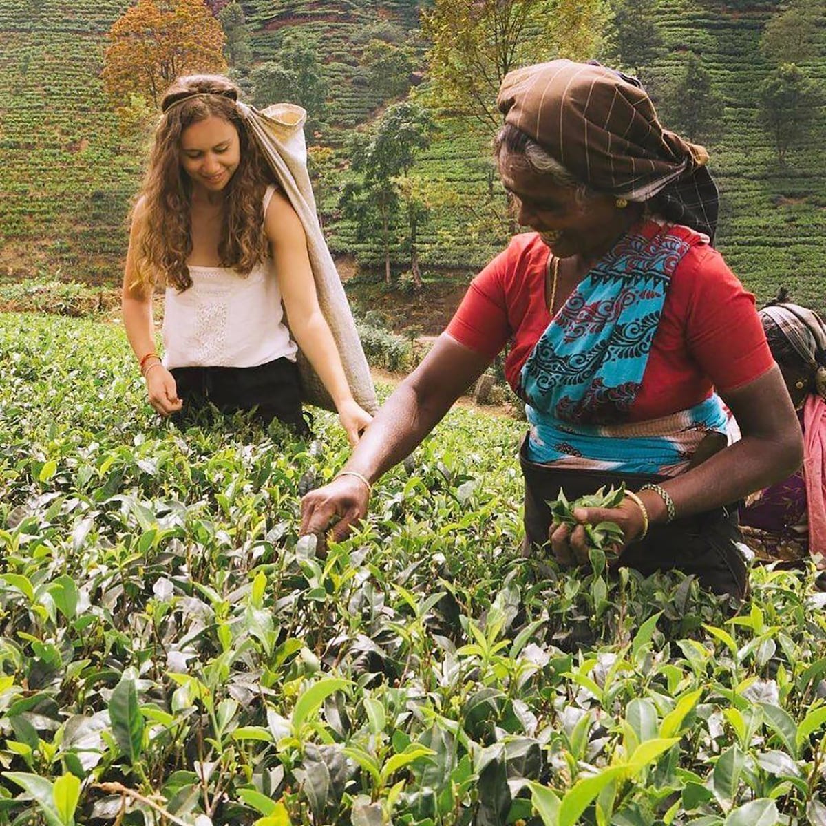
Location: The mountain is situated in the Nuwara Eliya District, part of Sri Lanka’s central highlands. It is located near the town of Nuwara Eliya, which is known for its tea plantations and temperate climate.

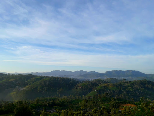
Geographical Significance: Great Western Mountain is part of the Central Mountain Range, a region known for its lush vegetation, tea estates, and varied climate. The area is characterized by rolling hills, cloud forests, and diverse ecosystems.

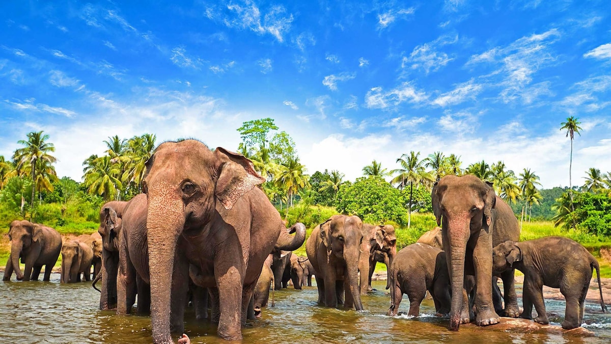
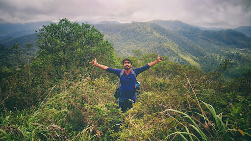
Flora and Fauna: The mountain and its surroundings support a rich variety of flora and fauna. The lower slopes are covered in tea plantations, while the higher elevations feature cloud forests with a range of endemic plant species. Wildlife in the area includes various bird species, small mammals, and insects.

Hiking and Trekking: Great Western Mountain is a popular destination for hikers and nature enthusiasts. The trek to the summit involves navigating through forested areas and offers spectacular views of the surrounding landscape, including the tea plantations and distant peaks. The hike is considered moderate in difficulty.

Climate: The climate around Great Western Mountain is generally cool and temperate, with frequent mist and cloud cover at higher elevations. Weather conditions can vary, so hikers should be prepared for changing conditions.

Conservation: The area around Great Western Mountain is part of the broader Central Highlands region, which is recognized for its ecological significance. Efforts are made to protect the natural environment and support sustainable tourism practices in the region.

Local Significance: Great Western Mountain, along with other peaks in the central highlands, contributes to the cultural and natural heritage of Sri Lanka. The mountain is a part of the scenic landscape that defines the highland region and supports local communities through tourism and agriculture.

In summary, Great Western Mountain is a significant peak in Sri Lanka’s central highlands, known for its natural beauty, biodiversity, and hiking opportunities. It is an important part of the region’s landscape, offering stunning views and contributing to the ecological and cultural richness...

   Read more
avatar
5.0
7y

Great hiking experience. 🐾️🌾 It is situated at western slope of Nuwara Eliya distric. ⛰️⛰️⛰️ 6th highest mountain (2216m) in Sri Lanka. Tough for beginners but there's a trail for the peak of the mountain and you can ascend easily to the top of mountain. First you have to come to the Great Western Railway Station. 🚉 The name for the mountain "Great Western" is from the Great Western railway station & the Great Western tea estate which are located in front of the mountain. The railway station is 1464m above mean sea level.

First you have to walk about 1km from Great Western railway station towards Radella railway station via the railway. 🛤️ Then you'll find a stone staircase to a hindu kovil on your left side. Go through it.There's a small water stream near the kovil. 💦 💦 💦 Turn right from the kovil and you'll find a trail. That's your way. When you reach about 1850m above mean sea level (according to google maps) you'll find  another water stream. Turn right from there.

If you have a strong rope it is valuable to your hike. Your ascending pathway to the top via a beautiful forest. 🌱🌳🍃🌿☘️🍀 You can see Piduruthalagala the highest mountain in Sri Lanka, Kikiliyamana, Shanthipura the highest village, Radella, Meepilimana, Conical Hill, Ambewela, Thotupola, Kirigalpoththa, Adam's Peak & Saptha Kanya from the top. There is a camping site at the top of the mountain but no water sourse is there.

When you come back there's a fresh & cold water spout. You can have a bath from there. You have to walk another few meters passing the entrance of the kovil, towards Radella railway station via the railway. Railway bridge also there. Great experience for your day today busy life. Come here, enjoy the environment. Feel the natural beauty. Don't ruin it. Don't throw garbage. Don't disturb to the balance of the...

   Read more
avatar
5.0
6y

6th highest mountain of Sri Lanka (about 2100m msl). Popular among hikers as a scenic destination as well as a camping site. To find the trail need to walk about 800m from the great western station. Near to a bridge on the right side the trail can be seen as a stair to a Kovil. From the kovil the trail runs to the mountaion from the right side of the kovil.The trail identical with a fig tree and a water stream. To reach the top it will take about 3 -4 hours. The upper part of the mountain is a sensitive cloud forest. At 1900m msl there is a another pure water stream and that is the last water stream that can find in the trail. Some areas the slope nearly 75° and need to careful near to cliffs. There are several view points at the top of the mountain and the camping site located near to the last viewpoint. Important *Moderate to Difficult hike. *Ropes may be required(if you are a beginer) **Strongly reccomond to not to go in rainy season. Slopes are deadly **If a begginer a guide reccomond (Mohan the best guide, if need can order food from Mohan - food quality -5 stars/deliciuos😋) **one day hike - yes *birds/frogs/plants observation *forest type -upper montane cloudy forest/top is a dwarf forest *weather -strong winds/misty **This place still untoched by many humans.So its very cool...please leave only the footprints/nothing else🙏🙏🙏 *if need ask for...

   Read more
Page 1 of 7
Previous
Next