TL;DR: Underwhelming death trap
Let me make this clear- if you are intent upon going to the hot springs, DO NOT TAKE DUGAS ROAD!
After exiting I-17, you will travel about 10 miles on a paved road. It's picturesque & scenic- beautiful foliage & even a few run ins with cows! & there were baby cows! Omg totes adorbs! It took about 15-20 minutes.
This is where the good times end as does the paved road. The next 19 miles are awful & took us ~ THREE & A HALF HOURS.
Miles 1-10: Some rocky terrain among an arid landscape. Lots of mesquite trees & a clearly laid path that was craggy in some parts but not that bad in others. If you have a vehicle w/ high clearance, an SUV, or a truck, you should be fine so long as you go slow. This part took about 1.5hrs to get through.
Miles 11-16: Go back now. Not worth it. The arid landscape gives way to a more forest like, mountain terrain. "It's so gorgeous!" we thought as we made the transition. The road seemed to narrow a bit, but nbd, right? We started to ascend the side of the mountain & the road continued to narrow until it became one lane. Okay, that's cool I guess. The terrain soon became incredibly precipitous w/ huge boulders right in the middle of the path. There were multiple times we had to stop & park, get out, & assess the situation before we could go on. Thankfully we only bottomed out once, but every 20ft or so the trees hugged our car tightly & scratched the entire length of the truck.
But it gets better. The trees start to give way on the driver side & soon it just turns into a cliff with a sheer drop of who knows how far. Eventually we get to a place where we can stop & take a breather, as we have literally been driving 2pmh for a solid hour. It's at this point where the cliff changes from the driver's side to the passenger side. Yea me!
We muster on & then we pass a bit of a ravine & I see some sort of yellow 1960s sedan that's run off the road & has now been used as target practice (keep it classy, Arizona) & this is where I start to envision my boyfriend & I falling off the side of a cliff & getting stranded w/ no cell phone service & a panic attack sets in. My bf tries to keep going while I am crying & thinking of death & we still have 7 miles left to go.
By about mile 16, it finally gives way to some nice, smooth terrain. You travel 2 miles like this & then the last mile is a bit rocky but nowhere near as scary. You will also roll up on a closed gate which is ok, you just have to get out & open/close it behind you.
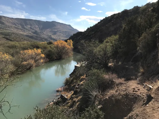
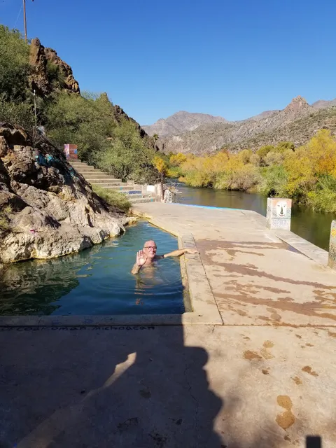
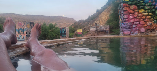
You finally get to the hot springs. It basically looks like the beginnings of a horror movie, as it's an abandoned farm of some sort, with surprisingly good cell reception. We parked just beyond this part, got out, & then hiked for about 15 min before we found the hot springs.
We were there for about 5 mins before we went back to the car. The water was incredibly filthy, & it did not look anything like the pictures on Instagram. I put my foot in to test the temp of the water & that was it. I shed a tear in anticipation of the drive back.
Luckily there was a forest road ~ 3 miles back that we ended up taking to go home & it was much safer. If you make the mistake of taking Dugas in, & need to get back to the Valley, you can take Forest Road 57 to 16 to 269 & you will end up in Carefree. Take screenshots on your phone of the map before you take this trek though, as there is ABSOLUTELY NO CELL SERVICE.
If after this, you still want to visit the Hot Springs here are some things to keep in mind:
Get a full tank of gas in Cordes before you drive. Or take another route.
Bring sunscreen, bug spray, chapstick.
-Tell someone where you are going ahead of time.
-If you haven't left the valley before 7am you will not return before dark.
-Check to see if there are any forest fires in the area. We looked on our drive up & it looked to be clear, but on our way home, the mountains were incredibly smoky/hazy. We think it was the wind carrying the smoke from the...
Read more