HTML SitemapExplore

The Narrows — Local services in Four Corners States

Name
The Narrows
Description
Nearby attractions
The Narrows
The Narrows Bottom Up, Hurricane, UT 84737
Nearby restaurants
Nearby local services
Orderville Canyon
Utah 84767, USA
Imlay Canyon
Utah 84737
Mystery Canyon
Utah 84737
The Narrows
Nearby hotels
Related posts
Keywords
The Narrows tourism.The Narrows hotels.The Narrows bed and breakfast. flights to The Narrows.The Narrows attractions.The Narrows restaurants.The Narrows local services.The Narrows travel.The Narrows travel guide.The Narrows travel blog.The Narrows pictures.The Narrows photos.The Narrows travel tips.The Narrows maps.The Narrows things to do.
The Narrows things to do, attractions, restaurants, events info and trip planning
The Narrows
United StatesUtahFour Corners StatesThe Narrows

Basic Info

The Narrows

Utah 84737
4.9(385)
Save
spot

Ratings & Description

Info

Outdoor
Adventure
Scenic
Family friendly
Off the beaten path
attractions: The Narrows, restaurants: , local businesses: Orderville Canyon, Imlay Canyon, Mystery Canyon, The Narrows
logoLearn more insights from Wanderboat AI.

Plan your stay

hotel
Pet-friendly Hotels in Four Corners States
Find a cozy hotel nearby and make it a full experience.
hotel
Affordable Hotels in Four Corners States
Find a cozy hotel nearby and make it a full experience.
hotel
The Coolest Hotels You Haven't Heard Of (Yet)
Find a cozy hotel nearby and make it a full experience.
hotel
Trending Stays Worth the Hype in Four Corners States
Find a cozy hotel nearby and make it a full experience.

Reviews

Live events

Ride and traverse East Zion Slot Canyons
Wed, Feb 11 • 9:00 AM
Orderville, Utah, 84758
View details

Nearby attractions of The Narrows

The Narrows

The Narrows

The Narrows

4.9

(367)

Open until 12:00 AM
Click for details

Nearby local services of The Narrows

Orderville Canyon

Imlay Canyon

Mystery Canyon

The Narrows

Orderville Canyon

Orderville Canyon

5.0

(1)

Click for details
Imlay Canyon

Imlay Canyon

3.3

(2)

Click for details
Mystery Canyon

Mystery Canyon

4.5

(6)

Click for details
The Narrows

The Narrows

4.9

(284)

Click for details
Get the Appoverlay
Get the AppOne tap to find yournext favorite spots!
Wanderboat LogoWanderboat

Your everyday Al companion for getaway ideas

CompanyAbout Us
InformationAI Trip PlannerSitemap
SocialXInstagramTiktokLinkedin
LegalTerms of ServicePrivacy Policy

Get the app

© 2025 Wanderboat. All rights reserved.

Reviews of The Narrows

4.9
(385)
avatar
5.0
7y

PARKING: As of June 26, 2018, the Springdale lots were NOT free unless you are staying at one of the inns/lodges. There are lots that cost 20usd per day that are close to the Springdale shuttle stops. There is also street parking near the Springdale shuttle stops that is free after 5pm. Otherwise it is 1USD for the first hour then 3.50USD for each additional hour. The Springdale shuttle will bring you to the Zion visitor center where you will need to take another shuttle to the last stop to start the hike.

PREPARING FOR THE HIKE: 
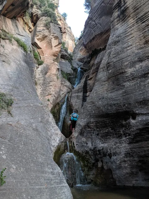
Check the weather and water conditions for the time of year you are going! I did it in late June and the water level and flow were low. You can rent equipment at the Zion Visitor Center, which includes waterproof hiking boots, neoprene socks to stay warm, a walking stick, waterproof bags. In June, the temperature of the water was about 63F, the ambient air was about 80-90F, which is cooler than the forecast for Zion, which was over 100F. I did it in shorts, a t-shirt, a walking stick, and water shoes without any socks and I was comfortable the whole day. Ideally having waterproof hiking shoes are best but water shoes with decent grip will suffice but only if you are careful and deliberate with your steps. A walking stick is a must because it will help you balance while taking steps, especially if you don't have good traction on your soles or your shoes have no ankle support. A walking stick also helps stabilize you on the more slippery areas. Also, without a walking stick and no ankle support you are asking for an ankle sprain. With that said, there were many people doing the trail in regular Nike or Asics sneakers and without walking sticks. The trail is mostly rocks and in the water areas the rocks are slippery.

I put my iPhone in a Ziploc bag and put that into another Ziploc bag and that was fine.
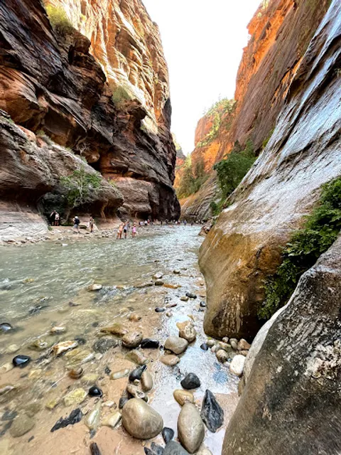
THE HIKE: 
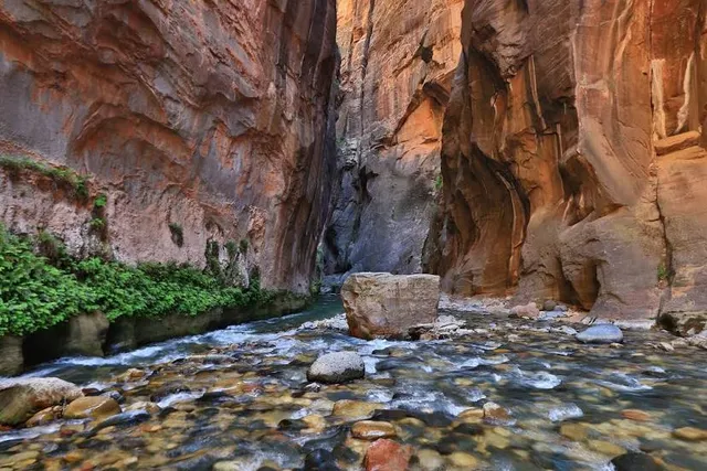
I did it at the end of June, and it was about 80% in water, varying from ankle to calves on average, with a few points up to my thighs. The deepest the water got was to my mid chest, which is avoidable by going around this section, but I chose to do it because why not? But keep in mind I went in late June when the water level and flow is low. It is mostly stepping over rocks, hence the care you need to take with each step to avoid injury. Minimize slips by using a walking stick! Don't be like the lady who didn't have a walking stick and slipped which caused her DSLR camera to dip into the water.

We started the hike at about 12:45PM and completed the round trip at 7PM. You can go as far as you like before turning around.

This hike is best done over a period of many hours because of the care you need to take with each step. Additionally, the surroundings are amazing and you want to take your time to bask in the nature.

There are no restrooms along the trail. Also, don't be an idiot and litter!

AFTER THE HIKE: Stretch, hydrate, and get proper nutrition to minimize soreness and cramps. I'm a medical professional, so please listen, especially about hydrating well before, during, and...

   Read more
avatar
5.0
3y

This is one of the most epic hikes - but there are many things to consider so that your hike is enjoyable and safe. Information below will be for a bottom up hike (out and back) that does not require a permit.

Gear: The Narrows can be hiked year round. In colder months, you want to be sure to get the appropriate gear so that your core body temperature does not drop. We rented waders, water shoes, neoprene socks, and a walking stick from Zion Outfitters. This kept us warm when hiking in March. The stick was such a valuable part of the gear because it is challenging to find solid footing at times when walking through the river. The stick helps you to maintain balance. *You can pick up your gear after 4 on the day before your hike so you can start early the next morning.

Water: You will need to pack in your own water. The water in the Virgin River is not potable due to cyanobacteria.

Parking: From mid-March to October, the park runs a shuttle bus from the visitor center to the Temple of Sinawava (the stop for The Narrows). If the shuttle is not running, you will have to drive to the parking lot at the Temple of Sinawava. Due to limited parking - get there very early (before sunrise) to get parking. You can rest in your car once you have a spot. If you arrive late, you. will have to park up the road at other roadside spots, and. this will add additional miles to your hike.

Distances: From the Temple of Sinawava, you begin walking on the Riverside Walk Trail. This is an easy, paved path for approximately 1.5 miles. At the end of this path, stairs lead down to the river. At this point, you will begin walking in the river. The water can get waist deep (or higher). Check with the park rangers before doing The Narrows because flash flooding can be dangerous.

You can walk as far as you want and then turn around to return to the Temple of Sinawava. If you want to see Wall Street (where the canyon becomes narrrow), you will need to walk approximately 2 miles once you enter the water at the end of The...

   Read more
avatar
4.0
3y

The most strenuous, hardest, longest, freezing and challenging hike I have ever done in my life. Rented the dry pants package from Zion outfitters and I honestly thought I'd just give it a try and maybe hike 0.5 miles in water. It's a total of 10 mile hike, first 1.1 mile is on the land, which is the only easy part. Once I got into the cold cold waters of November, I thought I'd be done in another 100 meters. But the views ahead where irresistible. So I thought I can go on until I get too tired or exhausted. At the 3 mile point is the floating rock, after which you hardly see people continuing. The insane us continued. No spectacular view beyond this point, but I had it in me to try and complete this challenging hike in water. So I did it! The end view is a small waterfall, so definitely don't do it for the view, do it for the experience and the challenging journey. I have had my whole body pain the following day, so chilled at bryce canyon.

Tips: If you're not a professional like me, and are still considering completing the bottom up hike, Go early! Rent your shoes, neoprene socks, dry pants and stick for this season, no second thoughts there! Every item they gave helped me complete this hike and couldn't have done without one. You can pick them up the previous evening, which I didn't do, but is recommended. The first shuttle is around 7 and it's a 45 min ride to the riverside walk which is gonna be part of the narrows hike. Get started early so that you can take your time to rest and continue, and come back by 6pm. 6.15 is the last shuttle. We started our hike after shuttle drop off at 9am and completed 10 miles by 5.30pm. Carry water n food, you'll need it. Sometimes you'll need to climb on few rocks or go a little over waist deep to cross a few points. Big dark rocks inside water are usually slippery, so check before you take a step. It's definitely not impossible to complete the hike in the cold waters, but it is for...

   Read more
Page 1 of 7
Previous
Next

Posts

Your browser does not support the video tag.
explore.hike.teachexplore.hike.teach
Eight Water Hikes to keep you cool in Southern Utah’s summer season 💧Zion Narrows - mileage varies. 2-17 miles green waters and soaring canyon walls. Most people take the shuttle and hike up the Virgin river and turn around when ready but if you secure a permit you can hike from the top down and camp overnight. 💧Pleasant Creek - slick rock chutes, cascades, tall slick rock walls. 7 miles RT 💧 Sulphur Creek - (no it doesn’t smell like sulphur)- 3 waterfalls, red rock slots. May require swimming. 6 mile hike requires shuttle. 💧 Paria Canyon - Most similar to the Zion’s Narrows, high solitude factor. Can do as a multi day through backpack trip or experience part of the canyon as a day trip out and back. 💧Willis Creek Slot- 3+ miles, family friendly. Can avoid the water. 💧Escalante river - Escalante Natural Bridge, Skyline Arch, Anasazi ruins and a Petroglyph panel. 6 miles RT or 15 mile through hike with shuttle. 💧Kanarraville Falls - permit required. 2 waterfalls, a natural water slide, and nontechnical slot canyon. 💧The Subway - permit required. Iconic. 9.6 miles out and back from bottom up or as a technical 9.5 mile top down hike. Remember all water hikes have an inherent risk of flash flooding. Know the weather and trail conditions and most importantly consult with a local ranger before you go. See link in bio for flash flood predictions by area. Which hike would you like to try first? Practice LNT (Leave No Trace) principles so everyone can enjoy for years to come. #southernutah #zionnarrows #zionnationalpark #waterhike #riverhike #nationalpark #hikingadventures #places_wow #findyourbackcountry #grandstaircaseescalante #kanab #idhikethat #capitolreefnationalpark #slotcanyon #utahhikes
Your browser does not support the video tag.
explore.hike.teachexplore.hike.teach
Since slot and water hikes have risk of flash floods you CAN prepare to hike at a safe time by checking the flash flood predictions for the local area through the National Weather Service. SAVE this post for this valuable resource. The forecast is found in the Flash Flood Prediction for Southern Utah ➡️ LINK IN BIO or at https://www.weather.gov/slc/flashflood Never do these types of hikes if the weather is stormy even miles away. Hikes shown in order: 📍The Subway (Zion National Park- permit required) 📍The Teepees via Wire Pass 📍Zion Narrows 📍Golden Cathedral 📍Singing Canyon 📍Buckskin Gulch ‼️Remember to leave no trace when Exploring outdoors -Plan and prepare -pack out all trash and waste - respect wildlife and other people
Your browser does not support the video tag.
explore.hike.teachexplore.hike.teach
Hikes with water might just be my favorite part of summer! SAVE so you don’t miss a single one 💧Wall Lake - 2.5miles- Easy Cliff jumping, SUP, Kayak 🐕Dogs permitted 💵 $6 day use or America the Beautiful pass. 💧Kanarraville Falls - 3.7 miles - Moderate. Slot Canyon, waterfalls, ladder 🚫No dogs 💵 $12 per person by permit only 💧Upper Farmington Canyon -3 miles-Moderate “car graveyard”, creek crossings, optional rope climb 🐕Dogs permitted 💧Cataract Gorge -6.5 miles -Moderate Can drive down the jeep road 🐕Dogs permitted 💵 $6 day use or America the Beautiful pass. 💧The Subway - 9.5 miles - Hard 🚫No dogs Permit required. Zion National park 💧Battle Creek Falls -1.2 miles -Easy 🐕Dogs permitted 💧 Sulphur Creek - 6 miles -Moderate 3 waterfalls, red rock narrows. natural wtaterslide requires 2 cars or shuttle. 🚫No dogs. Capitol Reef National Park 💧Pleasant Creek - 7 miles -Moderate slick rock chutes, cascades, soaring sandstone walls, petroglyphs, a natural bridge, and a side slot 🚫No dogs Capitol Reef National Park 💧Adams Canyon Waterfall 4 miles -Hard follow a creek/cascades, waterfall 🐕Dogs permitted 💧Upper Pine Creek Falls-.7 miles-Moderate Follow the creek, need to climb boulder to access the falls 🚫No Dogs ZIon National Park 💧Waterfall Canyon- 2.5 miles-Moderate Steep climb to 200 Ft falls 🐕Dogs permitted 💧Zion Narrows- currently closed due to high water Up to 10 mile round trip from the bottom-up 🚫No dogs Zion National Park ⚠️Remember all water hikes have an inherent risk of flash flooding. Know the weather (flash flood predictions for Utah LINK IN BIO) and trail conditions and most importantly consult with a local ranger before you go. ⭐️Practice LNT (Leave No Trace) principles so everyone can enjoy for years to come. Pack out all trash and 💩 Don’t mark up or stack rocks Be respectful to wildlife and fellow hikers.
See more posts
See more posts
hotel
Find your stay

Pet-friendly Hotels in Four Corners States

Find a cozy hotel nearby and make it a full experience.

Eight Water Hikes to keep you cool in Southern Utah’s summer season 💧Zion Narrows - mileage varies. 2-17 miles green waters and soaring canyon walls. Most people take the shuttle and hike up the Virgin river and turn around when ready but if you secure a permit you can hike from the top down and camp overnight. 💧Pleasant Creek - slick rock chutes, cascades, tall slick rock walls. 7 miles RT 💧 Sulphur Creek - (no it doesn’t smell like sulphur)- 3 waterfalls, red rock slots. May require swimming. 6 mile hike requires shuttle. 💧 Paria Canyon - Most similar to the Zion’s Narrows, high solitude factor. Can do as a multi day through backpack trip or experience part of the canyon as a day trip out and back. 💧Willis Creek Slot- 3+ miles, family friendly. Can avoid the water. 💧Escalante river - Escalante Natural Bridge, Skyline Arch, Anasazi ruins and a Petroglyph panel. 6 miles RT or 15 mile through hike with shuttle. 💧Kanarraville Falls - permit required. 2 waterfalls, a natural water slide, and nontechnical slot canyon. 💧The Subway - permit required. Iconic. 9.6 miles out and back from bottom up or as a technical 9.5 mile top down hike. Remember all water hikes have an inherent risk of flash flooding. Know the weather and trail conditions and most importantly consult with a local ranger before you go. See link in bio for flash flood predictions by area. Which hike would you like to try first? Practice LNT (Leave No Trace) principles so everyone can enjoy for years to come. #southernutah #zionnarrows #zionnationalpark #waterhike #riverhike #nationalpark #hikingadventures #places_wow #findyourbackcountry #grandstaircaseescalante #kanab #idhikethat #capitolreefnationalpark #slotcanyon #utahhikes
explore.hike.teach

explore.hike.teach

hotel
Find your stay

Affordable Hotels in Four Corners States

Find a cozy hotel nearby and make it a full experience.

Get the Appoverlay
Get the AppOne tap to find yournext favorite spots!
Since slot and water hikes have risk of flash floods you CAN prepare to hike at a safe time by checking the flash flood predictions for the local area through the National Weather Service. SAVE this post for this valuable resource. The forecast is found in the Flash Flood Prediction for Southern Utah ➡️ LINK IN BIO or at https://www.weather.gov/slc/flashflood Never do these types of hikes if the weather is stormy even miles away. Hikes shown in order: 📍The Subway (Zion National Park- permit required) 📍The Teepees via Wire Pass 📍Zion Narrows 📍Golden Cathedral 📍Singing Canyon 📍Buckskin Gulch ‼️Remember to leave no trace when Exploring outdoors -Plan and prepare -pack out all trash and waste - respect wildlife and other people
explore.hike.teach

explore.hike.teach

hotel
Find your stay

The Coolest Hotels You Haven't Heard Of (Yet)

Find a cozy hotel nearby and make it a full experience.

hotel
Find your stay

Trending Stays Worth the Hype in Four Corners States

Find a cozy hotel nearby and make it a full experience.

Hikes with water might just be my favorite part of summer! SAVE so you don’t miss a single one 💧Wall Lake - 2.5miles- Easy Cliff jumping, SUP, Kayak 🐕Dogs permitted 💵 $6 day use or America the Beautiful pass. 💧Kanarraville Falls - 3.7 miles - Moderate. Slot Canyon, waterfalls, ladder 🚫No dogs 💵 $12 per person by permit only 💧Upper Farmington Canyon -3 miles-Moderate “car graveyard”, creek crossings, optional rope climb 🐕Dogs permitted 💧Cataract Gorge -6.5 miles -Moderate Can drive down the jeep road 🐕Dogs permitted 💵 $6 day use or America the Beautiful pass. 💧The Subway - 9.5 miles - Hard 🚫No dogs Permit required. Zion National park 💧Battle Creek Falls -1.2 miles -Easy 🐕Dogs permitted 💧 Sulphur Creek - 6 miles -Moderate 3 waterfalls, red rock narrows. natural wtaterslide requires 2 cars or shuttle. 🚫No dogs. Capitol Reef National Park 💧Pleasant Creek - 7 miles -Moderate slick rock chutes, cascades, soaring sandstone walls, petroglyphs, a natural bridge, and a side slot 🚫No dogs Capitol Reef National Park 💧Adams Canyon Waterfall 4 miles -Hard follow a creek/cascades, waterfall 🐕Dogs permitted 💧Upper Pine Creek Falls-.7 miles-Moderate Follow the creek, need to climb boulder to access the falls 🚫No Dogs ZIon National Park 💧Waterfall Canyon- 2.5 miles-Moderate Steep climb to 200 Ft falls 🐕Dogs permitted 💧Zion Narrows- currently closed due to high water Up to 10 mile round trip from the bottom-up 🚫No dogs Zion National Park ⚠️Remember all water hikes have an inherent risk of flash flooding. Know the weather (flash flood predictions for Utah LINK IN BIO) and trail conditions and most importantly consult with a local ranger before you go. ⭐️Practice LNT (Leave No Trace) principles so everyone can enjoy for years to come. Pack out all trash and 💩 Don’t mark up or stack rocks Be respectful to wildlife and fellow hikers.
explore.hike.teach

explore.hike.teach

See more posts
See more posts