HTML SitemapExplore
logo
Find Things to DoFind The Best Restaurants

Pumalín National Park — Attraction in Chaitén

Name
Pumalín National Park
Description
Nearby attractions
Nearby restaurants
Nearby hotels
Related posts
Keywords
Pumalín National Park tourism.Pumalín National Park hotels.Pumalín National Park bed and breakfast. flights to Pumalín National Park.Pumalín National Park attractions.Pumalín National Park restaurants.Pumalín National Park travel.Pumalín National Park travel guide.Pumalín National Park travel blog.Pumalín National Park pictures.Pumalín National Park photos.Pumalín National Park travel tips.Pumalín National Park maps.Pumalín National Park things to do.
Pumalín National Park things to do, attractions, restaurants, events info and trip planning
Pumalín National Park
ChileLos Lagos RegionChaiténPumalín National Park

Basic Info

Pumalín National Park

Sector Río Amarillo S Chaiten, Chaitén, Los Lagos, Chile
4.8(773)
Closed
Save
spot

Ratings & Description

Info

Outdoor
Adventure
Scenic
Family friendly
Pet friendly
Off the beaten path
attractions: , restaurants:
logoLearn more insights from Wanderboat AI.
Phone
+56 65 243 6337
Website
conaf.cl
Open hoursSee all hours
Mon9 AM - 5:30 PMClosed

Plan your stay

hotel
Pet-friendly Hotels in Chaitén
Find a cozy hotel nearby and make it a full experience.
hotel
Affordable Hotels in Chaitén
Find a cozy hotel nearby and make it a full experience.
hotel
The Coolest Hotels You Haven't Heard Of (Yet)
Find a cozy hotel nearby and make it a full experience.
hotel
Trending Stays Worth the Hype in Chaitén
Find a cozy hotel nearby and make it a full experience.

Reviews

Get the Appoverlay
Get the AppOne tap to find yournext favorite spots!
Wanderboat LogoWanderboat

Your everyday Al companion for getaway ideas

CompanyAbout Us
InformationAI Trip PlannerSitemap
SocialXInstagramTiktokLinkedin
LegalTerms of ServicePrivacy Policy

Get the app

© 2025 Wanderboat. All rights reserved.
logo

Reviews of Pumalín National Park

4.8
(773)
avatar
4.0
2y

Park entrance from El Amarillo seems to be my favorite. The walk to Ventisquero is much more difficult than the hike out to the glacier. Signage throughout all park sections is inadequate. For example, where was the trail end toward the glacier on the Volcano Michimahuida hike? Did the trail end at the glacier? I hope not because attempting to reach the glacier can be treacherous especially when crossing Amarillo River currents. When returning from the glacier back to Camping Ventisquero, it is advisable to remain on the left side of the glacial runoff, otherwise hikers will not be able to wade safely further downstream before reaching Camping Ventisquero. The hike between Camping Ventisquero and the glacier is flat, hardly any change in elevation, whereas Sendero Mirador is more challenging but much shorter. The Sendero Ranita de Darwin is a very short walk, which starts out mildly, and then poses some degree of difficulty. Anyone with apiphobia might consider avoiding Ranita de Darwin because bumblebees have burrowed heavily into the second half of the trail and the wall bordering the path. They are buzzing everywhere currently. Park employees in both park sections are very friendly and enthusiastic about what...

   Read more
avatar
5.0
1y

Increíble lugar!!! 
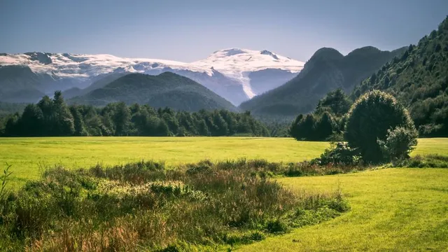
Si te gustan las selvas tropicales, pero no te gustan los mosquitos, ni el calor húmedo pegajoso, este es tu sitio. Aquí tenéis una selva fría con lo mejor de todo, increíbles vistas, cascadas, lagos, volcanes, árboles milenarios, bosques de helechos, nalcas y mucho musgo y líquenes que hacen que estos bosques no tengan nada que envidiar a una selva tropical. 
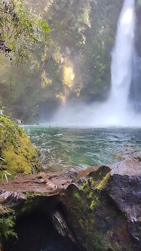
El sendero de las cascadas escondidas,( la baja y la alta) es alucinante, pero no hecho para todos los públicos, ya que las pasarelas parecen una vía Ferrara hecha de madera por la que a veces tendrás que bajar por escaleras muy verticales y un tanto resbaladizas en las que algún sitio falta un peldaño que otro, un tramo de barandilla. Aunque bien merece la pena por lo menos ir a la primera cascada si quieres encontrar la ubicación exacta de Pandora. 
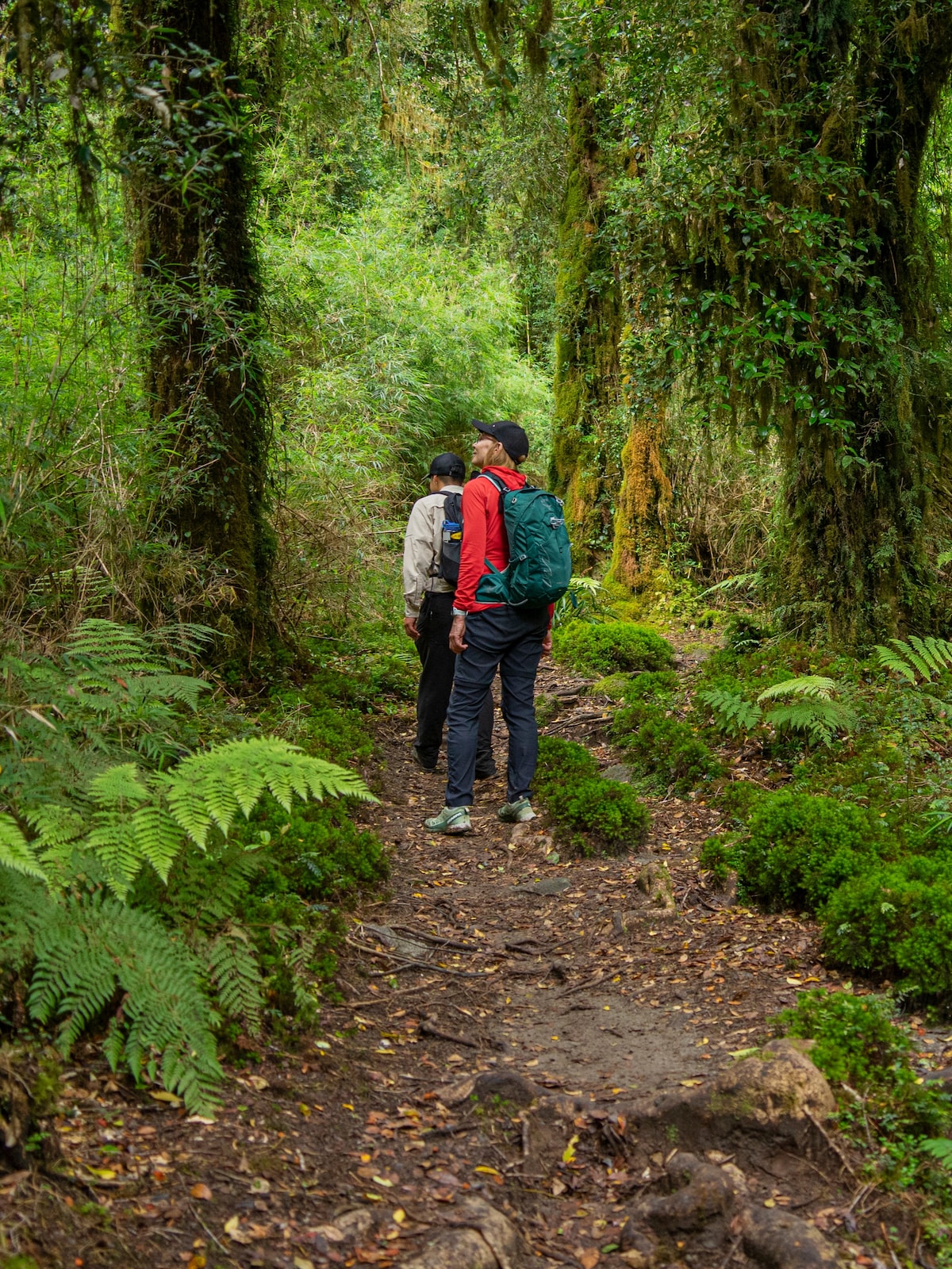
El paseo de los Alerces, es imperdonable no hacerlo. Alerces milenarios que pueden llegar hasta los 4000 años y crecen hasta los 60m de altura, con troncos de hasta más de 2m de diámetro rodeados de musgo y líquenes en todo su contorno. El sendero de Caleta Gonzalo y la cascada tronador tampoco tienen desperdicio. En la cascada tronador las pasarelas están echas un poco como como las otras dos cascadas, en plan vía Ferrata que hace que sea hasta divertido hasta cierta edad, yo no lo aconsejaría para mayores de 70 años que no estén ágiles. En Caleta Gonzalo las pasarelas están nuevas el primer tramo de una hora, te adentras por un camino bien marcado y nuevo. A partir de llegar a una plataforma que hay de madera al lado de un río, después de una hora, comienza la aventura de explorador de la jungla, por donde si tienes el valor suficiente de ir buscando el camino, y te atreves a pasar por algun resto de lo que antes fueron pasarelas de madera. Se irá convirtiendo en una aventura llegar a la cascada, después de otras 2h más. Intents que no se te haga tarde para la vuelta o tendrás que pasar la noche en la selva, ya que el camino en algunos sitios no está muy definido. Pero a medida que te sigues el sendero cada vez se hace más salvaje y bonito. 
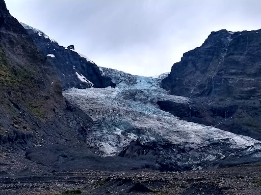
El volcán, pues subir, subir, subir, disfrutar de las vistas para volver a bajar, bajar, bajar. Me alegra ver que la gente los cuiden y estén, sin plásticos, ni papeles. Y todos mis respetos para la gente del parque por el trabajo que supone abrir un sendero por la selva, que no es nada fácil. Por favor! cuiden éste...

   Read more
avatar
5.0
7y

Pumalin, now called Pumalin Douglas Tompkins, is a massive National Park (larger than Yosemite in the US) and one of the centerpieces of Doug and Kris Tompkins largest ever land donation in the world. Highlights of the Amarillo section of the park are the hike to Michamuida Volcano and the Amarillo Hot Springs. In the Caleta Gonzalo area you will find trails to Chaiten Volcanos and ancient Alerce trees, which are among the oldest trees in the world and genetically similar...

   Read more
Page 1 of 7
Previous
Next

Posts

Your browser does not support the video tag.
anna_skifanna_skif
Самый красивый маршрут из всех в нашей кругосветке - Carretera Austral💔✨Здесь не просто встречаются красивые участки - красота сопровождает вас на всем пути и просто не заканчивается ⁣⁣⠀ ⁣⁣⠀ Мы взяли машину в Барилоче - начало Патагонии на аргентинской стороне. Toyota Corolla Cross 4х4 - ни разу не пожалели, что выбрали именно авто повыше. Дорога часто грунтовая - собственно, ей мы обязаны сколом на лобаше. Но по сравнению с тем, как тяжело было бы машинке поменьше, это ерунда.⁣⁣⠀ ⁣⁣⠀ Далее - граница с Чили ➡️11-часовой паром до первой точки (наш путь, правда, занял по итогу часов 19 из-за шторма🤪). Доехали до микро городка Chalten и стартуем:⁣⁣⠀ ⁣⁣⠀ 🚘Parque Nacional Pumalin - тропа Дарвиновской лягушки⁣⁣⠀ ⁣⁣⠀ 🚘Nevado Queulat - Mirador Ventisquero Colgante - Нависающий ледник⁣⁣⠀ ⁣⁣⠀ 🚘Coyhaique - столица региона Айсен (пополняем припасы)⁣⁣⠀ ⁣⁣⠀ 🚘Parque Nacional Cerro Castillo - можно увидеть Андских оленей ⁣⁣⠀ ⁣⁣⠀ 🚘Puerto Río Tranquilo - фантастические Marble Caves, которые собрали уже больше миллиона просмотров на нашей странице ⁣⁣⠀ ⁣⁣⠀ Очень надеюсь, что вы отправите это видео тому, с кем хотите проехать по Чили❤️⁣⁣⠀ ⁣⁣⠀ #шоссеаустрал #⁣⁣дорожноепутешествие #путешествиенамашине #идеяпутешествия #чили #патагония#карретерааустраль
James LehmanJames Lehman
Park entrance from El Amarillo seems to be my favorite. The walk to Ventisquero is much more difficult than the hike out to the glacier. Signage throughout all park sections is inadequate. For example, where was the trail end toward the glacier on the Volcano Michimahuida hike? Did the trail end at the glacier? I hope not because attempting to reach the glacier can be treacherous especially when crossing Amarillo River currents. When returning from the glacier back to Camping Ventisquero, it is advisable to remain on the left side of the glacial runoff, otherwise hikers will not be able to wade safely further downstream before reaching Camping Ventisquero. The hike between Camping Ventisquero and the glacier is flat, hardly any change in elevation, whereas Sendero Mirador is more challenging but much shorter. The Sendero Ranita de Darwin is a very short walk, which starts out mildly, and then poses some degree of difficulty. Anyone with apiphobia might consider avoiding Ranita de Darwin because bumblebees have burrowed heavily into the second half of the trail and the wall bordering the path. They are buzzing everywhere currently. Park employees in both park sections are very friendly and enthusiastic about what they are doing.
Alison MonsalveAlison Monsalve
Los paisajes son lindos. Cuenta con 3 senderos principales: Ventisquero el Amarillo (dificultad media-alta) Mirador (dificultad media) y Ranita de Darwin (dificultad baja) respecto al último, se supone que es interpretativo pero no tiene mayor información de nada. En general el parque tiene pésima señalización, si bien no nos perdimos, los días que estuvimos (4) nos pillamos con varios visitantes y automovilistas perdidos. Creo que en el sector del mirador, ranita de Darwin y camping, no es problema, pero es preocupante la pésima señalización al ventisquero el amarillo, ya que puede ser peligroso para la seguridad de los visitantes. En lo personal ibamos siguiendo las huellas de otros visitantes pero en caminos nos pillamos con varios visitantes fuera y bastante lejos del sendero establecido o con muchas complicaciones para cruzar el río. Lo otro negativo fue la atención del guardaparques, 0 autocontrol y muy mal educado para mantener una conversación en dónde manifestamos inquietudes, esto me llamó mucho la atención ya que, lo que caracteriza a los guardaparques de las reservas y parques que hemos visitado es la escucha activa y buen trato. El sujeto era muy desagradable, se jura patrón de fundo. En cuanto la infraestructura de este sector del parque, cuenta con 2 zonas de picnic y dos areas de camping cada uno con baños y duchas (agua helada)
See more posts
See more posts
hotel
Find your stay

Pet-friendly Hotels in Chaitén

Find a cozy hotel nearby and make it a full experience.

Самый красивый маршрут из всех в нашей кругосветке - Carretera Austral💔✨Здесь не просто встречаются красивые участки - красота сопровождает вас на всем пути и просто не заканчивается ⁣⁣⠀ ⁣⁣⠀ Мы взяли машину в Барилоче - начало Патагонии на аргентинской стороне. Toyota Corolla Cross 4х4 - ни разу не пожалели, что выбрали именно авто повыше. Дорога часто грунтовая - собственно, ей мы обязаны сколом на лобаше. Но по сравнению с тем, как тяжело было бы машинке поменьше, это ерунда.⁣⁣⠀ ⁣⁣⠀ Далее - граница с Чили ➡️11-часовой паром до первой точки (наш путь, правда, занял по итогу часов 19 из-за шторма🤪). Доехали до микро городка Chalten и стартуем:⁣⁣⠀ ⁣⁣⠀ 🚘Parque Nacional Pumalin - тропа Дарвиновской лягушки⁣⁣⠀ ⁣⁣⠀ 🚘Nevado Queulat - Mirador Ventisquero Colgante - Нависающий ледник⁣⁣⠀ ⁣⁣⠀ 🚘Coyhaique - столица региона Айсен (пополняем припасы)⁣⁣⠀ ⁣⁣⠀ 🚘Parque Nacional Cerro Castillo - можно увидеть Андских оленей ⁣⁣⠀ ⁣⁣⠀ 🚘Puerto Río Tranquilo - фантастические Marble Caves, которые собрали уже больше миллиона просмотров на нашей странице ⁣⁣⠀ ⁣⁣⠀ Очень надеюсь, что вы отправите это видео тому, с кем хотите проехать по Чили❤️⁣⁣⠀ ⁣⁣⠀ #шоссеаустрал #⁣⁣дорожноепутешествие #путешествиенамашине #идеяпутешествия #чили #патагония#карретерааустраль
anna_skif

anna_skif

hotel
Find your stay

Affordable Hotels in Chaitén

Find a cozy hotel nearby and make it a full experience.

Get the Appoverlay
Get the AppOne tap to find yournext favorite spots!
Park entrance from El Amarillo seems to be my favorite. The walk to Ventisquero is much more difficult than the hike out to the glacier. Signage throughout all park sections is inadequate. For example, where was the trail end toward the glacier on the Volcano Michimahuida hike? Did the trail end at the glacier? I hope not because attempting to reach the glacier can be treacherous especially when crossing Amarillo River currents. When returning from the glacier back to Camping Ventisquero, it is advisable to remain on the left side of the glacial runoff, otherwise hikers will not be able to wade safely further downstream before reaching Camping Ventisquero. The hike between Camping Ventisquero and the glacier is flat, hardly any change in elevation, whereas Sendero Mirador is more challenging but much shorter. The Sendero Ranita de Darwin is a very short walk, which starts out mildly, and then poses some degree of difficulty. Anyone with apiphobia might consider avoiding Ranita de Darwin because bumblebees have burrowed heavily into the second half of the trail and the wall bordering the path. They are buzzing everywhere currently. Park employees in both park sections are very friendly and enthusiastic about what they are doing.
James Lehman

James Lehman

hotel
Find your stay

The Coolest Hotels You Haven't Heard Of (Yet)

Find a cozy hotel nearby and make it a full experience.

hotel
Find your stay

Trending Stays Worth the Hype in Chaitén

Find a cozy hotel nearby and make it a full experience.

Los paisajes son lindos. Cuenta con 3 senderos principales: Ventisquero el Amarillo (dificultad media-alta) Mirador (dificultad media) y Ranita de Darwin (dificultad baja) respecto al último, se supone que es interpretativo pero no tiene mayor información de nada. En general el parque tiene pésima señalización, si bien no nos perdimos, los días que estuvimos (4) nos pillamos con varios visitantes y automovilistas perdidos. Creo que en el sector del mirador, ranita de Darwin y camping, no es problema, pero es preocupante la pésima señalización al ventisquero el amarillo, ya que puede ser peligroso para la seguridad de los visitantes. En lo personal ibamos siguiendo las huellas de otros visitantes pero en caminos nos pillamos con varios visitantes fuera y bastante lejos del sendero establecido o con muchas complicaciones para cruzar el río. Lo otro negativo fue la atención del guardaparques, 0 autocontrol y muy mal educado para mantener una conversación en dónde manifestamos inquietudes, esto me llamó mucho la atención ya que, lo que caracteriza a los guardaparques de las reservas y parques que hemos visitado es la escucha activa y buen trato. El sujeto era muy desagradable, se jura patrón de fundo. En cuanto la infraestructura de este sector del parque, cuenta con 2 zonas de picnic y dos areas de camping cada uno con baños y duchas (agua helada)
Alison Monsalve

Alison Monsalve

See more posts
See more posts