HTML SitemapExplore
Find Things to DoFind The Best Restaurants

Mount Merbabu — Attraction in Selo

Name
Mount Merbabu
Description
Nearby attractions
Mount Merbabu National Park
Area Kebun/Hutan, Banyuroto, Boyolali, Magelang Regency, Central Java 56481, Indonesia
Nearby restaurants
Nearby hotels
Related posts
Keywords
Mount Merbabu tourism.Mount Merbabu hotels.Mount Merbabu bed and breakfast. flights to Mount Merbabu.Mount Merbabu attractions.Mount Merbabu restaurants.Mount Merbabu travel.Mount Merbabu travel guide.Mount Merbabu travel blog.Mount Merbabu pictures.Mount Merbabu photos.Mount Merbabu travel tips.Mount Merbabu maps.Mount Merbabu things to do.
Mount Merbabu things to do, attractions, restaurants, events info and trip planning
Mount Merbabu
IndonesiaCentral JavaSeloMount Merbabu

Basic Info

Mount Merbabu

Suroteleng, Selo, Boyolali Regency, Central Java, Indonesia
4.6(1.5K)
Open 24 hours
Save
spot

Ratings & Description

Info

Outdoor
Adventure
Scenic
Off the beaten path
attractions: Mount Merbabu National Park, restaurants:
logoLearn more insights from Wanderboat AI.

Plan your stay

hotel
Pet-friendly Hotels in Selo
Find a cozy hotel nearby and make it a full experience.
hotel
Affordable Hotels in Selo
Find a cozy hotel nearby and make it a full experience.
hotel
The Coolest Hotels You Haven't Heard Of (Yet)
Find a cozy hotel nearby and make it a full experience.
hotel
Trending Stays Worth the Hype in Selo
Find a cozy hotel nearby and make it a full experience.

Reviews

Nearby attractions of Mount Merbabu

Mount Merbabu National Park

Mount Merbabu National Park

Mount Merbabu National Park

4.8

(1.4K)

Open 24 hours
Click for details

Things to do nearby

Garden walk & local meal, Undhak2 Kemiri Kaliurang
Sat, Dec 27 • 10:30 AM
Pakem, Special Region of Yogyakarta, 55582, Indonesia
View details
Get the Appoverlay
Get the AppOne tap to find yournext favorite spots!
Wanderboat LogoWanderboat

Your everyday Al companion for getaway ideas

CompanyAbout Us
InformationAI Trip PlannerSitemap
SocialXInstagramTiktokLinkedin
LegalTerms of ServicePrivacy Policy

Get the app

© 2025 Wanderboat. All rights reserved.

Reviews of Mount Merbabu

4.6
(1,450)
avatar
4.0
1y

Mount Merbabu (3,145 m) is the 3rd highest mountain in central Java, standing together with Mount Merapi as a brother and sister. Merbabu has 5 route to trek (Selo, Suwanting, Wekas, Cuntel and Thekelan).

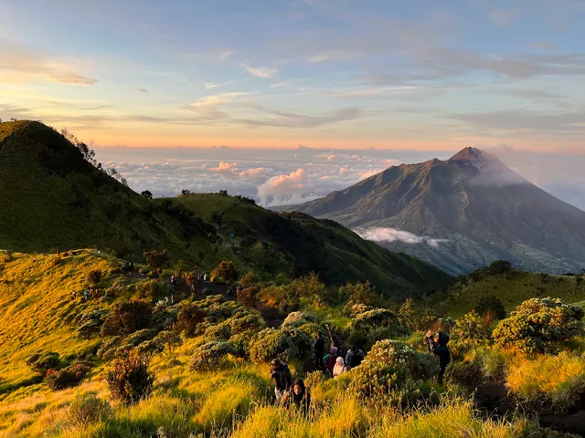
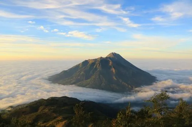
Even though the hiking trail is always going up and down but it offers you a good view of sunrise and a panoramic view of Mt.Merapi.

Before trekking you need to register on the national park's official website. It requires at least 3 people/group, if you are a solo traveler you can put your name on a website with the date to go. if someone wants to go on the same date and route, you would be invited to join the group and contact your friend via Whatsapp). It has a quota for each trekking route and sometimes is full on the weekend or public holidays.

The journey can be continued to Post 3 Batu Tulis which is at an altitude of 2,593 meters above sea level. Here, I and a group of climbers camped, you can also set up a tent because the area is so wide here or continue the journey to Savannah 2 if the temperature and weather support.

However, it would be nice to take a short walk to Sabana 1. Yes, the privilege of climbing Mount Merbabu lies in the extraordinary beauty of the savanna. Unmitigated, Mount Merbabu has two very large savanna fields. The location is not that far, uphill for about 30 minutes.

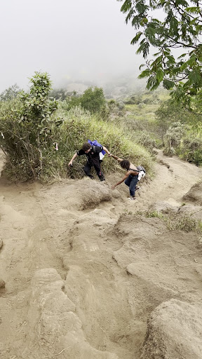
Indeed, to arrive at Sabana 1 from Post 3 Batu Tulis takes quite a long time, namely one hour. Even with climbing routes that really make your knees feel like they are going to fall off. However, all the tiredness will be paid off with the soul-satisfying beauty of the savanna.

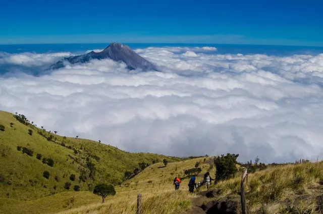
It's not surprising that many climbers choose to camp at Sabana 1 or Sabana 2. These two savannas are also favorite spots for climbers to take photos. The combination of the typical green of the savanna with the bright blue sky can seduce beauty lovers.

I started the summit attack around 4 am from post 3. I took the morning prayer at savanna 2.

After Sabana 2, the journey to the top of Mount Merbabu begins. Actually there are several peaks on Mount Merbabu, but the ones that can be traversed from the Selo route are Trianggulasi Peak and Kenteng Songo Peak.

The travel time to get to Trianggulasi Peak from Sabana 2 is approximately 90 minutes with an elevation of 916 meters. Regarding the climbing track, no need to ask. Just enjoy it. Because the peak that looks so close to the eye, is actually far away at the feet.

If you are tired, pause for a moment while looking at the scenery around Mount Merbabu. There is Mount Lawu in the east, Mount Merapi in the south, Mount Andong-Mount Telomoyo-Mount Ungaran in the north, and there is Mount Sindoro-Sumbing in the west. Also look at the vast expanse of edelweiss, cantigi trees and savanna. This landscape will more or less distract you from your feeling of tiredness. This good view can certainly be seen when the weather is clear.

After an hour's journey from Sabana 2, climbers will arrive at Triangulation Peak. At the same time, continue to Puncak Kenteng Songo, which is only 123 meters away with a travel time of 10 minutes.

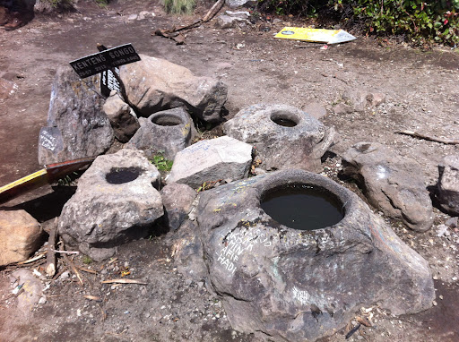
At the top of Kenteng Songo, there are six mortars or pounding tools made of stone and have concave holes. At this peak, climbers can enjoy unforgettable sunset and sunrise moments.

*It's not allowed to climb without registration, even if you go with a travel agency. If all of your group members are foreigners, a guide is required. **There is no phone signal on this route, but you can see the notifications at some point on the way. **Bring back all your garbages to check at the entrance gate. **There is no source of water available...

   Read more
avatar
5.0
1y

We did the merbabu trek starting from Selo. We begun with some confusing negotiations about registration for the hike - this should be done beforehand online but proved to be tricky for us so we managed in person for 150k a person.

We started at 1pm in cloudy misty conditions. We walked very quickly (3 of us fairly athletic in our 20s) nervous we had left it too late for sunset views up top. Despite locals saying it would take 5-7 hours to the top we managed it in 3 hours including our short breaks. We got to POS5 in just 2 hours. We got to the top just before sunset and had it to ourselves - it seems most groups camp and go for sunrise and maybe better chance of being alone at sunset. Initially we were entirely in cloud but we dropped just slightly and got great views on Merapi and of the sun setting on top of the cloud.

The route is well marked with posts and black and yellow tape. Both the posts and tape are reflective making them visible at night time as well which proved very useful for our post sunset descent.

Would definitely recommend to long trousers and long sleeve tops. Mostly for keeping the sand off and neater the summit for keeping warm too. We climbed on a misty coldish day even down in the valley (noticeable on the scooter ride in) so found ourselves quite cold on top wearing just a hoodie and tracksuit trousers. Would recommend jumper + warmer layer (thermal or fleece) + coat. The watery mist and wind combination was very cold at the top. Torches and head torches also recommended for sunset - very dark, steep descent with lots of loose ground.

The hike started off in the trees with fairly solid paths for first hour but once you reach the first rope it changes to be much sandier looser paths. Sometimes just sheer cliffs of loose sand which required going on all fours. Usually these sections had rope but particularly nearer the top less rope was provided. The final 900m distance (after pos5) took us an hour because of this and because the elevation of this last section was around 300m making it like 33degrees steep.

The hike wasn’t too busy - we probably passed 10 groups of more serious trekkers bringing up tents during our hike. We were the only group we met just day trekking.

Amazing views and very exciting hike. The sandiness made it unlike any hike I’ve done before and overlooking merapi was very cool. We managed the whole climb on 3 hours sleep and no food other than one pack of Oreo’s and 6 small bananas between three so it’s definitely possible...

   Read more
avatar
5.0
36w

Mount Merbabu, located in Central Java, is one of Indonesia’s prominent volcanoes, with an elevation of 3,145 meters above sea level. This stratovolcano offers a challenging yet rewarding hike, especially for those who enjoy outdoor trekking. Merbabu is known for its stunning views, particularly at sunrise, when the sky and morning mist create a breathtaking sight.

The hike to the summit takes trekkers through diverse ecosystems, ranging from dense tropical forests to expansive grasslands. Along the trails, you’ll encounter various species of flora and fauna, including wild orchids and mountain birds that are unique to this high-altitude region. There are also small craters along the route, remnants of the volcano's past activity, giving trekkers a glimpse into the geological history of the mountain.

At the summit, hikers are rewarded with spectacular panoramic views of Mount Merapi, Mount Sindoro, Mount Sumbing, and even the Java Sea on clear days. Merbabu is often chosen by those seeking a beautiful hiking experience without the risk of volcanic activity, unlike its neighboring volcano, Merapi.

There are several trekking routes to the summit, with the Selo route being one of the most popular due to its accessibility and stunning natural scenery. The hike is ideal for beginner climbers who want to experience a volcanic climb with a varied landscape, but without overly extreme conditions.

Overall, Mount Merbabu offers a remarkable hiking experience with magnificent views, while also providing insight into the geological and biodiversity richness of Indonesia's...

   Read more
Page 1 of 7
Previous
Next

Posts

Laura CLaura C
We did the merbabu trek starting from Selo. We begun with some confusing negotiations about registration for the hike - this should be done beforehand online but proved to be tricky for us so we managed in person for 150k a person. We started at 1pm in cloudy misty conditions. We walked very quickly (3 of us fairly athletic in our 20s) nervous we had left it too late for sunset views up top. Despite locals saying it would take 5-7 hours to the top we managed it in 3 hours including our short breaks. We got to POS5 in just 2 hours. We got to the top just before sunset and had it to ourselves - it seems most groups camp and go for sunrise and maybe better chance of being alone at sunset. Initially we were entirely in cloud but we dropped just slightly and got great views on Merapi and of the sun setting on top of the cloud. The route is well marked with posts and black and yellow tape. Both the posts and tape are reflective making them visible at night time as well which proved very useful for our post sunset descent. Would definitely recommend to long trousers and long sleeve tops. Mostly for keeping the sand off and neater the summit for keeping warm too. We climbed on a misty coldish day even down in the valley (noticeable on the scooter ride in) so found ourselves quite cold on top wearing just a hoodie and tracksuit trousers. Would recommend jumper + warmer layer (thermal or fleece) + coat. The watery mist and wind combination was very cold at the top. Torches and head torches also recommended for sunset - very dark, steep descent with lots of loose ground. The hike started off in the trees with fairly solid paths for first hour but once you reach the first rope it changes to be much sandier looser paths. Sometimes just sheer cliffs of loose sand which required going on all fours. Usually these sections had rope but particularly nearer the top less rope was provided. The final 900m distance (after pos5) took us an hour because of this and because the elevation of this last section was around 300m making it like 33degrees steep. The hike wasn’t too busy - we probably passed 10 groups of more serious trekkers bringing up tents during our hike. We were the only group we met just day trekking. Amazing views and very exciting hike. The sandiness made it unlike any hike I’ve done before and overlooking merapi was very cool. We managed the whole climb on 3 hours sleep and no food other than one pack of Oreo’s and 6 small bananas between three so it’s definitely possible for you! 🤙🏼
acidguruacidguru
Mount Merbabu, located in Central Java, is one of Indonesia’s prominent volcanoes, with an elevation of 3,145 meters above sea level. This stratovolcano offers a challenging yet rewarding hike, especially for those who enjoy outdoor trekking. Merbabu is known for its stunning views, particularly at sunrise, when the sky and morning mist create a breathtaking sight. The hike to the summit takes trekkers through diverse ecosystems, ranging from dense tropical forests to expansive grasslands. Along the trails, you’ll encounter various species of flora and fauna, including wild orchids and mountain birds that are unique to this high-altitude region. There are also small craters along the route, remnants of the volcano's past activity, giving trekkers a glimpse into the geological history of the mountain. At the summit, hikers are rewarded with spectacular panoramic views of Mount Merapi, Mount Sindoro, Mount Sumbing, and even the Java Sea on clear days. Merbabu is often chosen by those seeking a beautiful hiking experience without the risk of volcanic activity, unlike its neighboring volcano, Merapi. There are several trekking routes to the summit, with the Selo route being one of the most popular due to its accessibility and stunning natural scenery. The hike is ideal for beginner climbers who want to experience a volcanic climb with a varied landscape, but without overly extreme conditions. Overall, Mount Merbabu offers a remarkable hiking experience with magnificent views, while also providing insight into the geological and biodiversity richness of Indonesia's mountainous regions.
Sony WarsonoSony Warsono
Gunung Merbabu merupakan salah satu gunung berapi aktif di Jawa Tengah. Gunung ini memiliki ketinggian 3.145 meter di atas permukaan laut dan terletak di perbatasan antara Kabupaten Magelang dan Kabupaten Boyolali. Jalur Selo adalah salah satu jalur pendakian Gunung Merbabu yang paling populer. Jalur ini memiliki panjang sekitar 14 kilometer dan memiliki ketinggian sekitar 2.900 meter di atas permukaan laut. Jalur ini cocok untuk pendaki pemula karena memiliki trek yang relatif landai dan tidak terlalu curam. Pendakian Gunung Merbabu lewat jalur Selo biasanya dimulai dari Desa Selo, Kecamatan Selo, Kabupaten Boyolali. Dari Desa Selo, pendaki akan melewati beberapa pos pendakian, yaitu: Pos 1: Pos ini terletak di Dusun Selorejo, Desa Selo, Kecamatan Selo, Kabupaten Boyolali. Pos 2: Pos ini terletak di Dusun Selorejo, Desa Selo, Kecamatan Selo, Kabupaten Boyolali. Pos 3: Pos ini terletak di Dusun Selorejo, Desa Selo, Kecamatan Selo, Kabupaten Boyolali. Pos 4: Pos ini terletak di Dusun Selorejo, Desa Selo, Kecamatan Selo, Kabupaten Boyolali. Pos 5: Pos ini terletak di Dusun Selorejo, Desa Selo, Kecamatan Selo, Kabupaten Boyolali. Puncak Kenteng Songo: Puncak ini terletak di ketinggian 3.142 meter di atas permukaan laut. Pendakian Gunung Merbabu lewat jalur Selo biasanya memakan waktu sekitar 7-8 jam. Jalur ini memiliki trek yang relatif landai dan tidak terlalu curam, sehingga cocok untuk pendaki pemula. Namun, pendaki tetap harus berhati-hati karena jalur ini memiliki beberapa jalur yang licin dan berbahaya. Berikut adalah cerita pendakian Gunung Merbabu lewat jalur Selo yang saya alami: Bbrp waktu lalu, saya dan teman-teman saya mendaki Gunung Merbabu lewat jalur Selo. Kami berangkat dari Bandung untuk sejenak istirahat selama 2 hari di Yogya dan mengeksplore pantai2 di Selatan Yogya. Sebelum melanjutkan rencana pendakian hari berikutny. Setelah makan siang, kami memulai pendakian dari Pos 1. Pemandangan di sekitar pos ini sangat indah. Kami dapat melihat Gunung Merapi dan Gunung Merbabu yang berdiri kokoh di kejauhan. Kami berjalan dengan santai dan menikmati pemandangan di sekitar kami. Kami juga bertemu dengan beberapa pendaki lain yang sedang mendaki Gunung Merbabu. Pada pukul 18.00 WIB, kami tiba di Pos 4. Kami memutuskan untuk bermalam di pos ini. Kami mendirikan tenda dan memasak makanan untuk makan malam. Pagi harinya, kami melanjutkan pendakian ke Puncak Kenteng Songo. Kami berangkat dari Pos 4 pada pukul 03.30 WIB. Pendakian ke Puncak Kenteng Songo tidak terlalu sulit. Kami tiba di puncak pada pukul 05:30 WIB. Pemandangan dari Puncak Kenteng Songo sangat indah. Kami dapat melihat Gunung Merapi, Gunung Merbabu, Gunung Sindoro, dan Gunung Sumbing. Kami menghabiskan waktu sekitar 1 jam di puncak. Kemudian, kami turun dari puncak dan kembali ke Desa Selo. Kami tiba di Desa Selo pada pukul 12.00 WIB. Kami merasa puas dan senang telah berhasil mendaki Gunung Merbabu. Berikut adalah beberapa tips untuk pendakian Gunung Merbabu lewat jalur Selo: Pastikan kondisi fisik Anda fit. Gunung Merbabu memiliki ketinggian 3.145 meter di atas permukaan laut, sehingga pendakian membutuhkan stamina yang prima. Sebelum mendaki, sebaiknya lakukan latihan fisik secara rutin, seperti lari, jalan kaki, atau bersepeda. Pelajari jalur pendakian. Jalur Selo memiliki panjang sekitar 14 kilometer dan memiliki ketinggian sekitar 2.900 meter di atas permukaan laut. Jalur ini cocok untuk pendaki pemula karena memiliki trek yang relatif landai dan tidak terlalu curam. Namun, pendaki tetap harus berhati-hati karena jalur ini memiliki beberapa jalur yang licin dan berbahaya. Siapkan perlengkapan pendakian yang lengkap. Perlengkapan pendakian yang lengkap akan membuat pendakian Anda menjadi lebih nyaman dan aman. Perlengkapan yang harus disiapkan antara lain: Tas carrier Sepatu hiking Jaket tebal Senter Kompas Kupluk Peluit Perlengkapan P3K Makanan dan minuman Uang tunai Lakukan registrasi di pos perizinan. Pengunjung yang ingin mendaki Gunung Merbabu harus melakukan registrasi di pos perizinan yang terletak di Desa Selo
See more posts
See more posts
hotel
Find your stay

Pet-friendly Hotels in Selo

Find a cozy hotel nearby and make it a full experience.

We did the merbabu trek starting from Selo. We begun with some confusing negotiations about registration for the hike - this should be done beforehand online but proved to be tricky for us so we managed in person for 150k a person. We started at 1pm in cloudy misty conditions. We walked very quickly (3 of us fairly athletic in our 20s) nervous we had left it too late for sunset views up top. Despite locals saying it would take 5-7 hours to the top we managed it in 3 hours including our short breaks. We got to POS5 in just 2 hours. We got to the top just before sunset and had it to ourselves - it seems most groups camp and go for sunrise and maybe better chance of being alone at sunset. Initially we were entirely in cloud but we dropped just slightly and got great views on Merapi and of the sun setting on top of the cloud. The route is well marked with posts and black and yellow tape. Both the posts and tape are reflective making them visible at night time as well which proved very useful for our post sunset descent. Would definitely recommend to long trousers and long sleeve tops. Mostly for keeping the sand off and neater the summit for keeping warm too. We climbed on a misty coldish day even down in the valley (noticeable on the scooter ride in) so found ourselves quite cold on top wearing just a hoodie and tracksuit trousers. Would recommend jumper + warmer layer (thermal or fleece) + coat. The watery mist and wind combination was very cold at the top. Torches and head torches also recommended for sunset - very dark, steep descent with lots of loose ground. The hike started off in the trees with fairly solid paths for first hour but once you reach the first rope it changes to be much sandier looser paths. Sometimes just sheer cliffs of loose sand which required going on all fours. Usually these sections had rope but particularly nearer the top less rope was provided. The final 900m distance (after pos5) took us an hour because of this and because the elevation of this last section was around 300m making it like 33degrees steep. The hike wasn’t too busy - we probably passed 10 groups of more serious trekkers bringing up tents during our hike. We were the only group we met just day trekking. Amazing views and very exciting hike. The sandiness made it unlike any hike I’ve done before and overlooking merapi was very cool. We managed the whole climb on 3 hours sleep and no food other than one pack of Oreo’s and 6 small bananas between three so it’s definitely possible for you! 🤙🏼
Laura C

Laura C

hotel
Find your stay

Affordable Hotels in Selo

Find a cozy hotel nearby and make it a full experience.

Get the Appoverlay
Get the AppOne tap to find yournext favorite spots!
Mount Merbabu, located in Central Java, is one of Indonesia’s prominent volcanoes, with an elevation of 3,145 meters above sea level. This stratovolcano offers a challenging yet rewarding hike, especially for those who enjoy outdoor trekking. Merbabu is known for its stunning views, particularly at sunrise, when the sky and morning mist create a breathtaking sight. The hike to the summit takes trekkers through diverse ecosystems, ranging from dense tropical forests to expansive grasslands. Along the trails, you’ll encounter various species of flora and fauna, including wild orchids and mountain birds that are unique to this high-altitude region. There are also small craters along the route, remnants of the volcano's past activity, giving trekkers a glimpse into the geological history of the mountain. At the summit, hikers are rewarded with spectacular panoramic views of Mount Merapi, Mount Sindoro, Mount Sumbing, and even the Java Sea on clear days. Merbabu is often chosen by those seeking a beautiful hiking experience without the risk of volcanic activity, unlike its neighboring volcano, Merapi. There are several trekking routes to the summit, with the Selo route being one of the most popular due to its accessibility and stunning natural scenery. The hike is ideal for beginner climbers who want to experience a volcanic climb with a varied landscape, but without overly extreme conditions. Overall, Mount Merbabu offers a remarkable hiking experience with magnificent views, while also providing insight into the geological and biodiversity richness of Indonesia's mountainous regions.
acidguru

acidguru

hotel
Find your stay

The Coolest Hotels You Haven't Heard Of (Yet)

Find a cozy hotel nearby and make it a full experience.

hotel
Find your stay

Trending Stays Worth the Hype in Selo

Find a cozy hotel nearby and make it a full experience.

Gunung Merbabu merupakan salah satu gunung berapi aktif di Jawa Tengah. Gunung ini memiliki ketinggian 3.145 meter di atas permukaan laut dan terletak di perbatasan antara Kabupaten Magelang dan Kabupaten Boyolali. Jalur Selo adalah salah satu jalur pendakian Gunung Merbabu yang paling populer. Jalur ini memiliki panjang sekitar 14 kilometer dan memiliki ketinggian sekitar 2.900 meter di atas permukaan laut. Jalur ini cocok untuk pendaki pemula karena memiliki trek yang relatif landai dan tidak terlalu curam. Pendakian Gunung Merbabu lewat jalur Selo biasanya dimulai dari Desa Selo, Kecamatan Selo, Kabupaten Boyolali. Dari Desa Selo, pendaki akan melewati beberapa pos pendakian, yaitu: Pos 1: Pos ini terletak di Dusun Selorejo, Desa Selo, Kecamatan Selo, Kabupaten Boyolali. Pos 2: Pos ini terletak di Dusun Selorejo, Desa Selo, Kecamatan Selo, Kabupaten Boyolali. Pos 3: Pos ini terletak di Dusun Selorejo, Desa Selo, Kecamatan Selo, Kabupaten Boyolali. Pos 4: Pos ini terletak di Dusun Selorejo, Desa Selo, Kecamatan Selo, Kabupaten Boyolali. Pos 5: Pos ini terletak di Dusun Selorejo, Desa Selo, Kecamatan Selo, Kabupaten Boyolali. Puncak Kenteng Songo: Puncak ini terletak di ketinggian 3.142 meter di atas permukaan laut. Pendakian Gunung Merbabu lewat jalur Selo biasanya memakan waktu sekitar 7-8 jam. Jalur ini memiliki trek yang relatif landai dan tidak terlalu curam, sehingga cocok untuk pendaki pemula. Namun, pendaki tetap harus berhati-hati karena jalur ini memiliki beberapa jalur yang licin dan berbahaya. Berikut adalah cerita pendakian Gunung Merbabu lewat jalur Selo yang saya alami: Bbrp waktu lalu, saya dan teman-teman saya mendaki Gunung Merbabu lewat jalur Selo. Kami berangkat dari Bandung untuk sejenak istirahat selama 2 hari di Yogya dan mengeksplore pantai2 di Selatan Yogya. Sebelum melanjutkan rencana pendakian hari berikutny. Setelah makan siang, kami memulai pendakian dari Pos 1. Pemandangan di sekitar pos ini sangat indah. Kami dapat melihat Gunung Merapi dan Gunung Merbabu yang berdiri kokoh di kejauhan. Kami berjalan dengan santai dan menikmati pemandangan di sekitar kami. Kami juga bertemu dengan beberapa pendaki lain yang sedang mendaki Gunung Merbabu. Pada pukul 18.00 WIB, kami tiba di Pos 4. Kami memutuskan untuk bermalam di pos ini. Kami mendirikan tenda dan memasak makanan untuk makan malam. Pagi harinya, kami melanjutkan pendakian ke Puncak Kenteng Songo. Kami berangkat dari Pos 4 pada pukul 03.30 WIB. Pendakian ke Puncak Kenteng Songo tidak terlalu sulit. Kami tiba di puncak pada pukul 05:30 WIB. Pemandangan dari Puncak Kenteng Songo sangat indah. Kami dapat melihat Gunung Merapi, Gunung Merbabu, Gunung Sindoro, dan Gunung Sumbing. Kami menghabiskan waktu sekitar 1 jam di puncak. Kemudian, kami turun dari puncak dan kembali ke Desa Selo. Kami tiba di Desa Selo pada pukul 12.00 WIB. Kami merasa puas dan senang telah berhasil mendaki Gunung Merbabu. Berikut adalah beberapa tips untuk pendakian Gunung Merbabu lewat jalur Selo: Pastikan kondisi fisik Anda fit. Gunung Merbabu memiliki ketinggian 3.145 meter di atas permukaan laut, sehingga pendakian membutuhkan stamina yang prima. Sebelum mendaki, sebaiknya lakukan latihan fisik secara rutin, seperti lari, jalan kaki, atau bersepeda. Pelajari jalur pendakian. Jalur Selo memiliki panjang sekitar 14 kilometer dan memiliki ketinggian sekitar 2.900 meter di atas permukaan laut. Jalur ini cocok untuk pendaki pemula karena memiliki trek yang relatif landai dan tidak terlalu curam. Namun, pendaki tetap harus berhati-hati karena jalur ini memiliki beberapa jalur yang licin dan berbahaya. Siapkan perlengkapan pendakian yang lengkap. Perlengkapan pendakian yang lengkap akan membuat pendakian Anda menjadi lebih nyaman dan aman. Perlengkapan yang harus disiapkan antara lain: Tas carrier Sepatu hiking Jaket tebal Senter Kompas Kupluk Peluit Perlengkapan P3K Makanan dan minuman Uang tunai Lakukan registrasi di pos perizinan. Pengunjung yang ingin mendaki Gunung Merbabu harus melakukan registrasi di pos perizinan yang terletak di Desa Selo
Sony Warsono

Sony Warsono

See more posts
See more posts