Gyilkos - tó
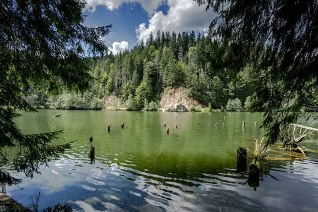
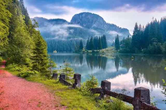
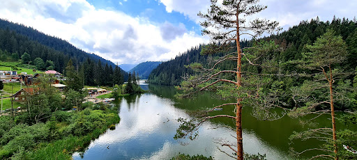
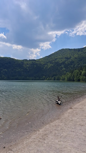
A Békás-szorostól csak pár kilométerre fekvő Gyilkos-tó, Erdély egyik legszebb torlasztava, mely 983 m tengerszint feletti magasságban található. A tó földcsuszamlás, völgyelzáródás által jött létre 1837-ben. A tóból fenyőfák állnak ki . A Gyilkos nevet onnan kapta, hogy a folklór szerint a drasztikusan és váratlanul feltöltődő tóban nyájak és pásztorok lelték halálukat. A környék meseszép , valódi látványosság a magashegyi vidék : haragoszöld rétek, mezők , legelõk, sietős száguldó patakok, hatalmas fenyvesek, tekervényes kacskaringós utak, magasztosan meseszép látképpel . Legszívesebben 100 méterenként megállna az ember nézelõdni, fényképezni. Nehéz elszakadni ettõl a csodálatos helytõl, de ha elindulunk a Hagymás-patak völgyén keresztül, rövidesenn elérhetünk a 983 m magasan elterülõ páratlan természeti ritkasághoz, a Gyilkos-tóhoz. Orbán Balázs a „Székelyföld leírása” című művében nem leplezi csodálatát, amikor így ír: „ A legmeglepõbb, a legelragadóbb képek egyike áll elõttünk. Még ma is, aki felsõ Olaszország nagyszerű és Svájcnak nagyszerű tavait látta, bámulattal fog e látvány elõtt megállni. Nagyobbszerű tüneményt talán igen, de szebbet, vonzóbbat bizonnyal nem rejtenek a havasok keblökben.” Ennél megragadóbban aligha lehetne szólni Székelyföld egyik legelbűvölőbb természeti ritkaságáról. 1837 egyik tomboló ítéletidőnek éjjelén a semmibõl képződött. A gyilkos-hely szétázott földje lecsúszott a szurdokba és elrekesztette az ott folyó Hagymás, Cohárd, Vereskõ és Likas patakok medrét. Az így létrejött gát hatására tóvá duzzadva alakult ki ez a természeti különlegesség. A tó létrejöttének számtalan mondáját alátámasztja a titokzatos, sejtelmes atmoszféra, melyet a tó medrébõl még ma is kiálló megkövesedett fatörzsek látképe tesz mélyrehatóvá. A látványos benyomást a tó köré tömörülő csúcsok teszik lenyűgözővé, úgymint a Kis-Cohárd (1352 m), Nagy-Cohárd (1507 m) és a Gyilkos-kõ (1406 m). A tó vize gyakorta és rendszeresen vörhenyes színű, amely nevéhez társítva már-már borzongatóan félelmetesen hat. A bűnős a jelenségben a Vereskõ-patak, amely nagyobb csapadékozás idején kioldja a környezet vasokker tartalmát, és megszínezi a tó vizét. A mítosz másik verziója mindazonáltal az állítások ellenére konokul tartja magát, mely szerint a tó kialakulásakor a föld csordapásztorokat is maga alá temetett, s az õ vérük festi vörössé a vizet. A tó körül magas szintű idegenforgalmi ellátás jött létre, a Békás-szoros közellétének jóvoltából. Amennyiben csak néhány órát töltünk a Gyilkos-tó környékén, akkor is béreljünk csónakot, amivel a kidõlt fenyõcsonkok között ügyesen taktikázva csónakázhatunk a tó egy részén. Emlékei között majd csodálatosan nagyszerű helyet foglal majd el az az egy, vagy fél óra, amit a tavon tölt. Béke, csend , harmónia, elragadó természeti szépség , rejtelmes hangulat, kihívás, mellettünk szelíden úszó tõkésrécék, körbe-körbe impozáns és grandiózus hegyormok, kristálytiszta levegõ. Ugye jól hangzik? Akinek több ideje van, mindenképpen sétáljon föl a Kis-Cohárd-sziklához (kék háromszög jelzés kb. másfél óra oda-vissza), ahonnan káprázatos látvány az ajándékunk a Gyilkos-tóra és a környék meseszép hegycsúcsaira. A környék, a Gyilkos-tó és a Békás-szoros 1996-tól nemzeti park. Egy könnyed séta alkalmából érdemes a tavat körbe is kerülni, hiszen jól járható, jelzéssel ellátott ösvényen fedezhetjük fel ezt az egyedülálló...
Read more