HTML SitemapExplore

Sitno — Attraction in Ilija

Name
Sitno
Description
Nearby attractions
Hrad Sitno
969 01 Ilija, Slovakia
Nearby restaurants
Nearby local services
Nearby hotels
Chata Andreja Kmeťa - Sitno
969 01 Ilija, Slovakia
Related posts
Keywords
Sitno tourism.Sitno hotels.Sitno bed and breakfast. flights to Sitno.Sitno attractions.Sitno restaurants.Sitno local services.Sitno travel.Sitno travel guide.Sitno travel blog.Sitno pictures.Sitno photos.Sitno travel tips.Sitno maps.Sitno things to do.
Sitno things to do, attractions, restaurants, events info and trip planning
Sitno
SlovakiaRegion of Banská BystricaIlijaSitno

Basic Info

Sitno

969 01 Ilija, Slovakia
4.8(241)
Open 24 hours
Save
spot

Ratings & Description

Info

Outdoor
Adventure
Scenic
Family friendly
Pet friendly
Off the beaten path
attractions: Hrad Sitno, restaurants: , local businesses:
logoLearn more insights from Wanderboat AI.

Plan your stay

hotel
Pet-friendly Hotels in Ilija
Find a cozy hotel nearby and make it a full experience.
hotel
Affordable Hotels in Ilija
Find a cozy hotel nearby and make it a full experience.
hotel
The Coolest Hotels You Haven't Heard Of (Yet)
Find a cozy hotel nearby and make it a full experience.
hotel
Trending Stays Worth the Hype in Ilija
Find a cozy hotel nearby and make it a full experience.

Reviews

Nearby attractions of Sitno

Hrad Sitno

Hrad Sitno

Hrad Sitno

4.8

(49)

Open 24 hours
Click for details
Get the Appoverlay
Get the AppOne tap to find yournext favorite spots!
Wanderboat LogoWanderboat

Your everyday Al companion for getaway ideas

CompanyAbout Us
InformationAI Trip PlannerSitemap
SocialXInstagramTiktokLinkedin
LegalTerms of ServicePrivacy Policy

Get the app

© 2025 Wanderboat. All rights reserved.

Reviews of Sitno

4.8
(241)
avatar
5.0
3y

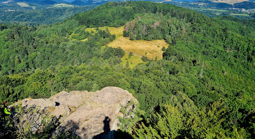
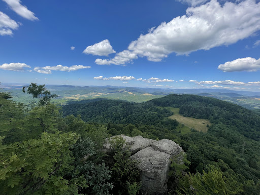
Sitno pohladi na dusi. Hodinovy vystup od Pocuvadlianskeho jazera stoji za to. Hore chata s zakladnym obcerstvenim a fayn teraskou na posedenie. Nedaleko zrucanina hradu, davaju to pomalicky dokopy a je odtial fayn vyhlad.

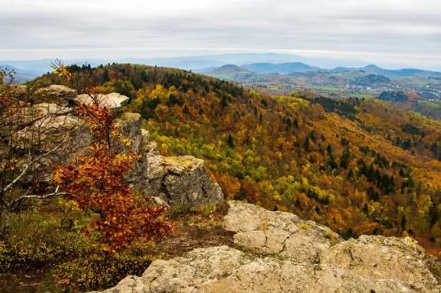
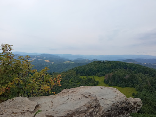
Sitno (1 009,2 m n. m.) je najvyšší vrch pohoria Štiavnické vrchy. Nachádza sa neďaleko Banskej Štiavnice a je považovaný za kolísku európskej horskej turistiky. Steny z andezitu obklopujú z troch strán vrchol, na ktorom je rozhľadňa a Vysielač Sitno.

Štiavnické vrchy a Sitno vôbec, sú považované za kolísku európskej pešej horskej turistiky - prvý turistický krúžok tu vznikol v roku 1860. Prvý písomne ​​doložený turistický chodník na území vtedajšieho Uhorska vyznačil Sitniansky klub v roku 1874. Chodník začínal v Hodruši prechádzal k Počúvadelskému jazeru, na Sitno a do Sklenených Teplíc.[6] Po roku 1880 bolo pod vedením Dr. Téryho v okolí Sitna vyznačených sto kilometrov turistických chodníkov, a stále sa budovali nové chodníky a horské studničky. 12. mája 1882 založil Téry Sitniansky spolok maďarsko-karpatskej jednoty, ktorý mal o tri roky už 194 členov. (Pokiaľ turistika vo forme púte bola samozrejme známa dávno predtým, Klub českých turistov, ktorý vznikol 1888 začal značkovať v roku v roku 1889. V Británii Commons Preservation Society a National Footpaths Society boli na tento účel zlúčené v roku 1899). Systém turistických značiek používaných na Sitne sa stal štandardom nie len vo všetkých okolitých krajinách (aj Česku) ale napríklad v Izraeli, Filipínach alebo Brazílii.[7]

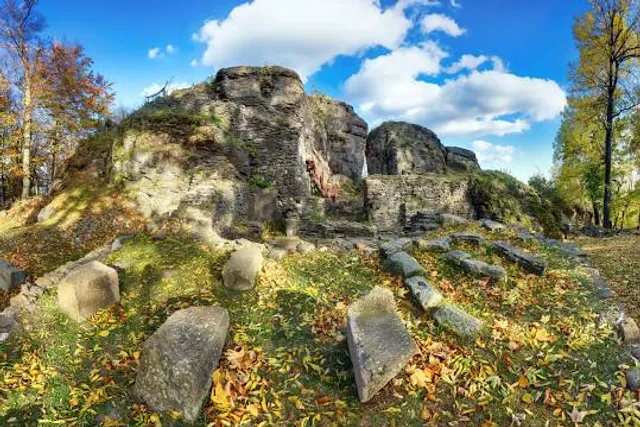
V roku 1929 bola horáreň na Sitne prestavaná na turistickú chatu Andreja Kmeťa. V auguste 2020 bola obnovená možnosť prespať na chate. Je tam 15 postelí v jednej miestnosti a poplatok je dobrovoľný. Od septembra 2020 bude potrebné si miesto rezervovať na Facebooku.[8]

V historickej rozhľadni boli inštalované expozície archeologických nálezov z hradu (história tlmočená textom aj fotografiami) i artefakty sitnianskej fauny, flóry, minerálov ako aj...

   Read more
avatar
4.0
4y

Nice and rather short hike (cca 1h following the green marking off the Počuvadlo lake). First half mid-steep very rocky path (parts in water in rainy May), then beautiful meadows and the final part (blue marking) steep, surrounded by tall rocks. The wooden stairs desperately ask for renewal - be careful. The view from the top is magnificent. You can see the entire collapsed mid of the stratovolcano crater.

Nearby, you can find ruins of a castle, unavoidable giant transmitter tower (unfortunately). The Andrej Kmeto cottage is in a very...

   Read more
avatar
5.0
7y

The Sitno ranks to the most iconic Slovak mountains. The Sitno mountain features lovely meadows with stunning flower carpets. The most popular (and also fastest) climb starts on the Počúvadlo Tajch (lake). The climb is easy and takes anything between 40 and 80 minutes. The final part of the trail is particularly beautiful. Several flights of wooden stairs pass steep volcanic rocks. The climb is easy and you can do it any time of the year. You can see the Danube River and the Budapest City on...

   Read more
Page 1 of 7
Previous
Next

Posts

Tilly SimonTilly Simon
Nice and rather short hike (cca 1h following the green marking off the Počuvadlo lake). First half mid-steep very rocky path (parts in water in rainy May), then beautiful meadows and the final part (blue marking) steep, surrounded by tall rocks. The wooden stairs desperately ask for renewal - be careful. The view from the top is magnificent. You can see the entire collapsed mid of the stratovolcano crater. Nearby, you can find ruins of a castle, unavoidable giant transmitter tower (unfortunately). The Andrej Kmeto cottage is in a very poor condition.
Vladimir BalazVladimir Balaz
The Sitno ranks to the most iconic Slovak mountains. The Sitno mountain features lovely meadows with stunning flower carpets. The most popular (and also fastest) climb starts on the Počúvadlo Tajch (lake). The climb is easy and takes anything between 40 and 80 minutes. The final part of the trail is particularly beautiful. Several flights of wooden stairs pass steep volcanic rocks. The climb is easy and you can do it any time of the year. You can see the Danube River and the Budapest City on a clear day.
Kamil DemočkoKamil Demočko
Pretty steep hill up, with beautiful views. We got back another way, going to see the castle ruins and taking adjecent path back to the clearing. As there are multiple parking spot make sure you're going the right way, as it is easy to go wrong way as there aren't a lot of signs along the route.
See more posts
See more posts
hotel
Find your stay

Pet-friendly Hotels in Ilija

Find a cozy hotel nearby and make it a full experience.

Nice and rather short hike (cca 1h following the green marking off the Počuvadlo lake). First half mid-steep very rocky path (parts in water in rainy May), then beautiful meadows and the final part (blue marking) steep, surrounded by tall rocks. The wooden stairs desperately ask for renewal - be careful. The view from the top is magnificent. You can see the entire collapsed mid of the stratovolcano crater. Nearby, you can find ruins of a castle, unavoidable giant transmitter tower (unfortunately). The Andrej Kmeto cottage is in a very poor condition.
Tilly Simon

Tilly Simon

hotel
Find your stay

Affordable Hotels in Ilija

Find a cozy hotel nearby and make it a full experience.

Get the Appoverlay
Get the AppOne tap to find yournext favorite spots!
The Sitno ranks to the most iconic Slovak mountains. The Sitno mountain features lovely meadows with stunning flower carpets. The most popular (and also fastest) climb starts on the Počúvadlo Tajch (lake). The climb is easy and takes anything between 40 and 80 minutes. The final part of the trail is particularly beautiful. Several flights of wooden stairs pass steep volcanic rocks. The climb is easy and you can do it any time of the year. You can see the Danube River and the Budapest City on a clear day.
Vladimir Balaz

Vladimir Balaz

hotel
Find your stay

The Coolest Hotels You Haven't Heard Of (Yet)

Find a cozy hotel nearby and make it a full experience.

hotel
Find your stay

Trending Stays Worth the Hype in Ilija

Find a cozy hotel nearby and make it a full experience.

Pretty steep hill up, with beautiful views. We got back another way, going to see the castle ruins and taking adjecent path back to the clearing. As there are multiple parking spot make sure you're going the right way, as it is easy to go wrong way as there aren't a lot of signs along the route.
Kamil Demočko

Kamil Demočko

See more posts
See more posts