Despite some concerns with crowds during October near Helen, we made our first trip to climb Mount Yonah in Cleveland, GA, on Sunday 10/16. Although the parking lot was full before we arrived around 10:30 am, there are a lot of parking spots and a long gravel approach road that you can park along, so we had no issues. In addition to adequate parking, there is also a double “outhouse style” bathroom building, which is great to have access to as a lady about to hike a busy trail, despite the primitive nature. Also, note that this trailhead and parking lot are apparently open 24/7, so sunset and sunrise hikes are possible here. Make sure to search for “Mount Yonah trailhead” on gps and maps, as I am told “Yonah Mountain” takes you to a private road at a different access point.
As far as the trail itself, I was surprised at the workout given that it is about 4.5 miles round trip. The first 2 miles is essentially straight up the mountain, with rock steps and boulders to climb over at certain points, and a lot of loose rocks and gravel along moderately steep inclines. A lot of people were stopping to catch their breath along the way, and from what I heard in conversation, not everyone made it to the top. Although this isn’t the most difficult trail I have been to by any means, this is definitely not a trail for anyone with mobility issues or less than average fitness. But if you are in fair shape and/or don’t mind a rewarding challenge where you might need to pause along the way, this is for you! The 2 miles down was obviously much easier, but some people might have knee trouble or problems with the loose footing at times as it is almost all straight downhill.
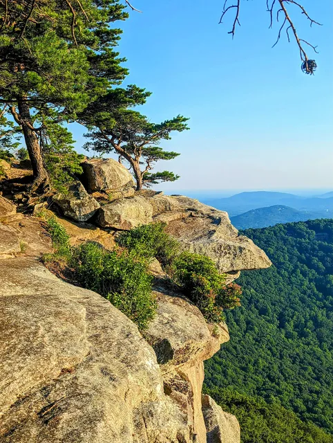
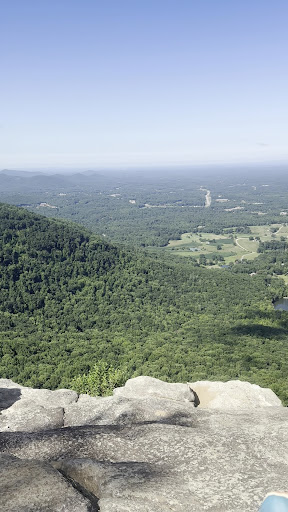
The open views from the rocks at the top are some of the best I have seen for such a short hike. The hike takes you straight up to the rock face that is visible from the parking lot below, which allows for several different areas to sit and look out over the mountains and scenery. This was nice, as it allowed the people to be spread out a bit around a trail loop at the peak, so it did not seem too crowded or rushed despite there being a lot of people on the mountain. I have to add a word of caution, as someone apparently fell to their death on the mountain a few hours after we left (no real details yet) - there are certainly plenty of dangerous places if you get close to the edge, but just be smart. There are several areas for bouldering and rope holds on some of the rock faces, so the mountain certainly can be enjoyed safely. Definitely worth the moderate hike to get to the glorious nature vistas at the top!
If you are looking for something to do afterward, check out Tantrum Brewing Co., which is basically right at the end of the access roads, along with Yonah Burger (it was closed on Sunday). Tantrum had a great food truck, and a surprisingly large selection of very tasty beer. There are a lot of outdoor tables, seating, and games, so it is a great family friendly post-hike stop before you head...
Read moreThe real scoop! It's really all about the view you get at the end of the trail! Miles and miles of unobstructed views at top. I was surprised how busy the trail was. I bet there were over 100 cars combined between at the trailhead parking area and running down the road leading up to trailhead on a Sunday in Februrary in the 40 and low 50s. Road leading to trailhead is a typical forest service road, so lots of ruts and erosion, but saw plenty of small sedans go up with no issues (if rainy might be slippery in the clay). The trail itself is quite a climb, but I found it can be done in 60 minutes to the top with a good pace and a few short breaks along the way. Plenty of areas to stop and rest along the way without holding up others behind you. Saw a lot of dogs with hikers along way, many with no leashes, but most seemed fairly obedient. Trail has a lot of loose rocks at various points, so definitely recommend hiking boots. Trail transitions from all rocks to mud and roots to gravel at various places. There are small green reflectors periodically spaced on trees, but seemed like a lot of fun "short cuts" and alternate routes up the top that all connected in the end. Once at the top, there's a particularly scenic view point over the summit kinda hidden that's completely unobstructed and what you typically see in the photos. There are plenty of safe spots at the top to rest, eat lunch, etc. with kids, though unless your kiddos are used to hiking, probably would avoid under age 6. Definitely bring water though. There are some out-houses about 2/3 of the way up. The descent can be done in about 45 min with a swift pace and really is just a matter of slowing yourself down to avoid losing control. Sure was a lot of fun and the view is absolutely breathtaking at the top. Not for faint of heart, but at the same time you can slow down the pace and take breaks so I saw all kinds of ages along trail. Probably budget around 2.5-3 hrs minimum for round trip with time to rest and soak in at top. The hike was definitely worth it...
Read moreLots o parking. Restrooms. No potable water. Not much shade in parking area. No trash cans for the losers who leave their junk in the bathrooms. There is a trash can near the bathrooms at the half way mark though. Easy to find. Tough hike- the second half. Great views. It would be nice if someone would drop an atomic bomb on the bathrooms near the top of the summit. I don't know who managed them in the past but its 2023 isn't it time to fix them or remove them? Can be crowded during summer weekends. The switch-backers are making a mess of the trails, erosion, etc. If you are in such a hurry to see the top, look at the pictures and save yourself a trip. The Forest Service is working on closing the switch-backs which is making a difference. The parking lot gets crowded during popular times. The access road has been repaired! It's still a little bumpy and muddy after rain however. Great hike, lots of fun, and not much wildlife. Want to hike more? Turn around and hike back to the top. Great views, good place to camp on top. It's about two miles to the top. It takes me fifty minutes to arrive at the meadow on top. I hike very fast, it will take you a longer time, pace yourself. Stay on the green marked trail/road past the bathrooms, it is faster and easier, or don't and suffer the consequences.
Water info: there is a bridge on the trail that crosses a stream less than a mile from the parking area. And there is another stream in a ravine on your left as you head up the trail before the bridge. They are both lower during the Summer. Before you reach the top there is a small small spring that has been forced to create a very small pond. A small, nasty pond. It is lower during the Summer. You will have to filter...
Read more