I've lived down the street from Ka`au for the last 40+ years and have been hiking/camping here for about 30.
A few things to note that other comments may not address:
There are rescues here every week by Honolulu Fire Department via helicopter. Also, if you follow the "trailhead" route, you will hike past two to three parcels that are privately owned, a Board of Water Supply parcel, and a large state parcel. If you traverse these parcels you are technically trespassing and can be cited and called to court. This is not a state sanctioned/maintained trail and taxpayers don't want to foot the bill for liability (very high cost over the decades) of someone getting injured where they aren't even allowed in the first place. I don't know why this location was reposted on Google Maps as the state, fire department, and many people who live around here don't want hikers illegally parking and trespassing.
Do not take an infant or dog if you plan on going past the first waterfall. It's more difficult than you may think and many people with infants and dogs have had to be rescued at residents' expense.
If you plan to park and hike, make sure you are not on an "unimproved sidewalk". Most of the areas that can fit a car there fall under this classification. You can and most likely will be cited. If in doubt, look up the Revised Ordinances of Honolulu Section 15-14.1 online. Understand that signs are not required for enforcement regarding most of the prohibitions.
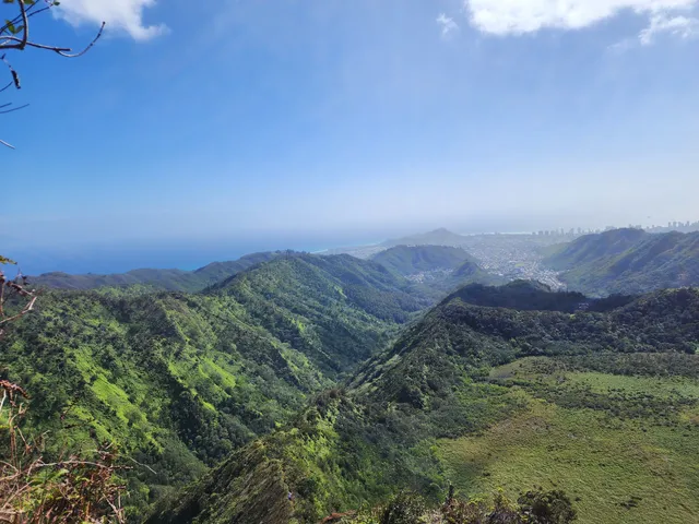
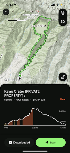
There are two ways to get to the crater and beyond. If you follow the main maintenance access trail (which follows the old and new water main) you will be taken through the three waterfalls to the punawai (natural spring) that Waiōmao Stream originates from. From there, you can go left or right to follow the dangerous, erosion-affected ridges. This route can be considered beginner until the first waterfall, intermediate through the second and third, and advanced from the crater to the Ko`olau ridge. Many people just go to the first waterfall and turn around as it is satisfying for those who donʻt want to spend the whole day hiking. Someone just died falling down the trail next to the second waterfall this year (2024).
The other way involves crossing the stream for the 5th time from the trailhead, and going up the low ridge to the left. This trail bypasses all three waterfalls for an express trip to the crater and beyond. This is the safer route, with less of a view. This route can be considered beginner all the way to the crater, but advanced from crater to ridge.
Do not go during rain, after heavy rain, or if rain is forecasted. A friendʻs mother passed away in the 1990s after attempting to cross the stream on the way back while the flow was too powerful. It is very hard to tell whether the flow is safely traversable, and itʻs best to cross when under knee high.
If you donʻt know, we have whatʻs known as "rotten basalt" on many ridges. The rock looks solid until it crumbles away. Some sections are solid while others are not. Learn the difference before attempting this hike. Also, stay away from the edges of the trail. Uluhe ferns grow on many sections and it can be difficult to sense where the solid ground ends as the ferns grow over the edges, concealing them from view.
Stay off of side trails. Some of these lead to private property, are used for permitted hunting, or have pakalolo growing near them (cannabis). The growers tend to put booby traps around their plants so best to avoid these areas or risk becoming severely injured.
Clean your shoes before hiking here to ensure you donʻt track invasive plant species into indigenous/endemic plant habitat (this area has many native plants and most are critically endangered).
Finally, donʻt go beyond your limits, donʻt be a wise a** towards residents, and if you take your dog with you...keep it on a leash!!! If people are respectful, hikers will be tolerated here. If not, expect regular patrols by HPD and DLNR.
I only gave this hike 3 stars since there are much better hikes on Oahu...
Read moreI was invited on this hike with a group of much younger people. While I truly loved this hike, it would have been nice if I had been warned of it difficulty. I am 50 years old. 6’0 and 195lbs. I’m not in perfect shape, but I also am not in bad shape. I hike a lot of the trails on the island, walk a lot and ride a bicycle to and from work. This trail was very difficult for me.
The access to this trail is back in a residential neighborhood which as enough parking space for about 5 cars MAX.
Upon entering the trail, you descend to a river and follow it to a well-groomed trial. The beginning of this trial is fairly easy even though there are areas where you have to be careful or you could fall and get hurt. This situation remains constant until you reach the first waterfall. When you reach the first waterfall I would recommend turning back if you are not in good shape, as you now will need to climb the waterfall to continue. The good part here is that on the right side there are ropes in place to help your ascent. After this waterfall, there is a Second and a Third, all with ropes to help your ascent, and it’s all uphill from here.
The trail continues to climb steeply and once on the crater ridge the trail becomes narrow with very long drop offs in some places, the kind of cliffs you DO NOT want to fall from.
When I did the hike it was a nice sunny day, no clouds in the sky and very little wind. It was miserable hot and the sun beat down ceaselessly. If you are able, I would do this hike on an overcast day but not on a rainy day. This trail would be very dangerous on slippery muddy tails and tall cliffs to fall from.
By the time I reached the top it had gotten so steep I had to stop about every 50 feet to rest, and when I finally reached the top I had used all my food and water. My heart was pounding in my ears and I was light headed. I sat at the top for almost 45 minutes just to get the will to move again and start the trek back down.
The hike down was easier but no safer. Narrow dirt trial with loose debris ending almost in a cliff in some places, again ropes are in place to help the decent but you have to be careful and use the ropes for safety. Once you get back into the trees the tail gets easier but my knees had almost given out on me.
This was a very memorable hike. I am glad I took plenty of pictures because I doubt I would ever hike this again as it took me over 6 hours to complete the...
Read moreVery pretty views from the top. Before the top, there are hardly any views. The top is often covered in clouds, so then there are no views. Trail is very rough and a bit dangerous in the rain.
The views from the top are certainly worth the hike. I could see Pearl Harbor & Honolulu on one side, and Rabbit Island & Chinaman's Hat on the other. The crater was below me on one side, and a long steep slope of the mountain was on the other. Wind and clouds flew past me. The waterfalls on the way up were pretty too, though nothing unique or spectacular.
The first section of the trail is quite steep and very uneven. When the sign says the trail is not maintained, it means it. We hiked up and back the same way, though most people do a loop. It was raining on the way up, and the mud made many sections difficult to traverse without sliding off the trail. We didn't have boots because we flew here with only carry ons, but I'd recommend them.
The 3 waterfalls are pretty steep and involve some light rock climbing or pulling yourself up with the help of some ropes tied to trees (no need to bring your own). The going is pretty slow, especially because passing is nearly impossible and the sections are long. Rain also makes these sections quite slippery and harder.
Other reviews found that the top section was harder, but I disagree. I thought the 2nd and 3rd waterfalls more difficult and dangerous than anything after that. the wind is certainly a factor at the top, but even with wet mud to scramble up I thought it wasn't extreme. There are many steep sections and you will probably use your hands half the time.
To the top and back the same way by the waterfalls took me 4.5 hours and measured 5.3 miles according to my phone's gps. From the base to the first waterfall was 1.5 miles and took almost an hour and a half. it stopped raining when i was close to the top which sped things up significantly on the way down.
parking at the base is almost non-existent, so consider drop off or ride share.
i didn't need any water or food. there's plenty of moisture in the air, and really for 5 hours you're fine in almost any condition. I personally prefer to travel with less and eat / drink when i return. a backpack could throw balance off, but that's provisions are personal preference.
have fun! it's worth the hike...
Read more